
This page features 11 amazing mountain cabins in the Arizona mountains.
You can reserve yours online from here.
With miles upon miles of national forest and park lands to explore, visitors have no shortage of outdoor activities to choose from.
Be sure to click through on each Colorado mountain cabin entry below to read the full description before you reserve your spot.
Access & amenities vary widely.
KENTUCKY CAMP CABIN AND HEADQUARTERS BUILDING, Arizona Campground Images, Info & Reservations
Listen Directions From Tucson, take I-10 east to Exit #281 (Highway 83 – Sonoita/Patagonia). Travel south on Highway 83 for approximately 21 miles to the signed turnoff for Gardner Canyon Road. Turn right on Gardner Canyon Road and continue 0.9 mile to Forest Service Road 163. Turn right on Forest Service Road 163 and continue approximately 5 miles to the entrance to Kentucky Camp. Stay to the left and continue to the parking lot and gate that marks the entrance to Kentucky Camp. There are signs to Kentucky Camp from Highway 83. Phone 520-281-2296 Activities CAMPING, HIKING, HUNTING, WILDLIFE VIEWING, MOUNTAIN BIKING, BIRDING, HISTORIC SITES, WINERY TOURS Keywords Related Link(s) Rec Area Info & Images Arizona State Tourism Arizona State Road Conditions Overview Kentucky Camp Cabin and Headquarters is located in the Santa Rita Mountains near Sonoita, Arizona in the Coronado National Forest. The five adobe buildings originally served as
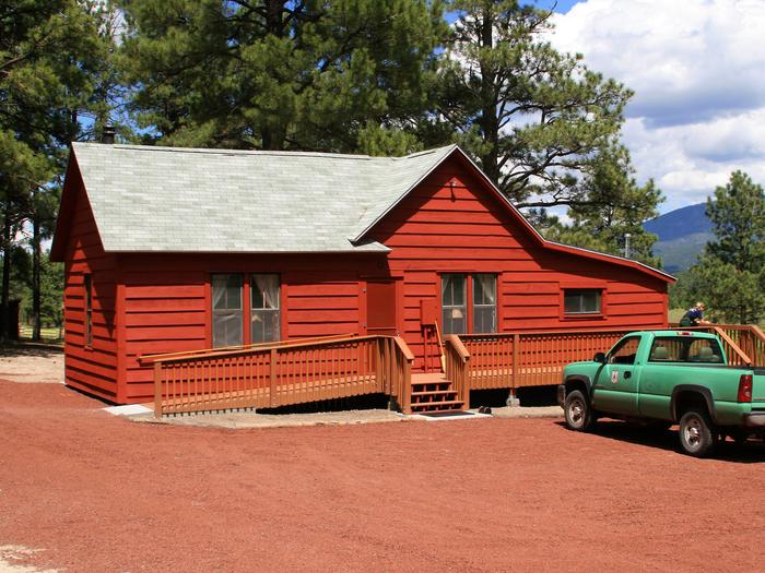
HULL CABIN, Arizona Campground Images, Info & Reservations
Listen Directions The cabin is located approximately 16 miles east of the town of Tusayan, Arizona on a graded gravel road. From Highway 64/180, turn east onto Forest Road 302 just south of the Grand Hotel in Tusayan. Turn left at the junction of Forest Roads 302 and 310. Follow Forest Road 310 for 1.5 miles and turn right on Forest Road 307. Follow the signs to Hull Cabin, which is just over a mile further. From State Highway 64 at the South Rim entrance station of Grand Canyon National Park (requires an additional entrance fee to the park), drive north for 4 miles. Turn right, staying on Highway 64, and continue east for approximately 8.7 miles, past a left turn sign for Grandview Point. Continue driving east on Highway 64 for 2 more miles (for a total of 10.7 miles after 64 turns east at the canyon rim). After
KENT SPRINGS CABIN, Arizona Campground Images, Info & Reservations
Listen Directions From the intersection of I-10 and I-19 in Tucson, travel south on 1-19 about 35 miles to the Continental Road exit (Exit 63) in Green Valley, Arizona. Turn left (east) onto Continental Road and go approximately 1 mile to the junction with the Madera Canyon/White House Canyon Road. Turn right (southeast) and travel approximately 14 miles into Madera Canyon. Stay on the paved road. The signed access road to the cabin is the second left past the Madera Kubo Bed and Breakfast Phone 520-281-2296 Activities HISTORIC & CULTURAL SITE, CAMPING, INTERPRETIVE PROGRAMS, HIKING, WILDLIFE VIEWING Keywords Kent Springs,Kent Springs Cabin Rental,Madera Canyon,KENT SPRINGS CABIN (AZ) Related Link(s) Rec Area Info & Images Arizona State Tourism Arizona State Road Conditions Overview Kent Springs Cabin is located in the Madera Canyon Recreation Area, 15 miles southeast of Green Valley, Arizona in the Coronado National Forest. Located in an area boasting
SYCAMORE CABIN, Arizona Campground Images, Info & Reservations
Listen Directions From Phoenix, take I-17 north about 80 miles to Exit 268, the Dugas/Orme Road exit. Go east toward Dugas. You will be on Forest Service Road 68. Travel east 8 miles continuing past Dugas for half a mile and then turn right (south) at the "Sycamore A.S." (Forest Service Road 68F) road sign. Continue 1 mile to the cabin. Phone (928) 567-4121 DURNING OFFICE HOURS 0800-430 M-F Activities BIKING, CAMPING, FISHING, HIKING, HORSEBACK RIDING, WILDLIFE VIEWING Keywords SYCA,PRESCOTT NF – FS Related Link(s) Rec Area Info & Images Arizona State Tourism Arizona State Road Conditions Overview Sycamore Cabin provides a unique recreation opportunity and lodging experience for visitors to Prescott National Forest. In 1938, the Civilian Conservation Corps constructed the cabin, which served as a residence for the district ranger and later, as housing for fire crews during fire season. The cabin’s capacity is up to eight people,
HORSETHIEF CABIN, Arizona Campground Images, Info & Reservations
Listen Directions From Phoenix, Arizona: When traveling Northbound on I-17 take the Bumble Bee Exit 248 and continue North on the dirt road, taking Forest Road (FR) 259 to Crown King. From Crown King, take (FR) 259A south for 0.5 mile to the junction of 52. Take FR 52 southeast for about 5 miles to the Horse Thief Basin Recreation Area. The cabin sits adjacent to the Horse Thief Lake Rd. Alternate route from Flagstaff, Arizona: Traveling Southbound on I-17 take Exit 263, turn right and proceed towards a roundabout and merge onto Hwy 69 North towards Prescott for 2.4 miles until turning left on to Spring Ln. in Spring Valley. Continue down Spring Ln. for 0.7 Miles until you get to Duffers Dr. turn right onto Duffers Dr. The road will become unpaved, continue to travel for 1.4 miles until you get to the intersection of Duffers Dr. and
SPRING VALLEY CABIN BUNKHOUSE, Arizona Campground Images, Info & Reservations
Listen Directions From Flagstaff, follow Interstate 40 west for about 30 miles and take exit 178 at Parks. Proceed one-tenth of a mile and turn left onto Old Route 66. Follow this road about a half-mile, then turn right onto Spring Valley Road/County Road 141, at the Old Parks Store. Continue on County Road 141 to the intersection of Forest Road 76, just past milepost 8 (pavement ends just before reaching milepost 6). Look for the Spring Valley Cabin sign. Turn left on Forest Road 76, and proceed less than a mile. The cabin will be on the left. From Williams, travel east on Interstate 40 for about 14 miles and take exit 178 at Parks. Follow the directions above to the cabin. Phone 928-635-5600 WILLIAMS RANGER STATION 8-4:30 M-F Activities BIKING, CAMPING, HIKING, HORSEBACK RIDING, HUNTING, WINTER SPORTS, WILDLIFE VIEWING Keywords SPRV,ROOM WITH A VIEW,SPRING VALLEY WORKCENTER,SPRING VALLEY RANGER
KENDRICK CABIN, Arizona Campground Images, Info & Reservations
Listen Directions From Interstate 17 or Interstate 40 in Flagstaff, follow signs to Highway 180 toward the Grand Canyon. From Flagstaff, drive approximately 20 miles north on Fort Valley Road/Highway 180 and look for the Watchable Wildlife Trail on the left and a roadside chapel on the right. Continue less than a mile past the chapel and turn right onto Forest Road 514. Go exactly one mile and turn left at sign for Kendrick Cabin. You will see a sign “Road Closed, Forest Service Administrative Site” as soon as you turn left. The cabin is a half-mile further at the end of this road. Phone 928-526-0866 Activities BIKING, CAMPING, HIKING, HUNTING, WILDLIFE VIEWING Keywords KENR,COCONINO NF – FS Related Link(s) Rec Area Info & Images Arizona State Road Conditions Arizona State Tourism Overview Kendrick Cabin offers groups of up to 10 people the chance to experience spectacular mountain views, numerous
FERNOW CABIN, Arizona Campground Images, Info & Reservations
Listen Directions Fernow Cabin is located approximately 22 miles south of Flagstaff on Forest Road 231. All roads are suitable for passenger vehicles, with caution required for the last mile. High-clearance vehicles are recommended. During periods of heavy rainfall, roads may become difficult to navigate. Roads are not always maintained after each weather event. From Phoenix, travel north on Interstate 17 to the junction with Interstate 40 in Flagstaff. Go west on Interstate 40. Turn right at the Flagstaff Ranch Road exit and continue to the stop sign. Turn right onto historic U.S. Route 66. Turn right at the Woody Mountain Campground, onto Forest Road 231 (Woody Mountain Road) and continue for 21 miles. At Forest Road 231A, continue along Forest Road 231 for less than a mile, taking the second right, onto Forest Road 231E/Fernow Draw. The cabin is a quater-mile further on Forest Road 231E. From Flagstaff, take
CALDWELL CABIN, Arizona Campground Images, Info & Reservations
Listen Directions Caldwell Cabin is located approximately 30 miles southwest of Alpine, Arizona and is accessible via Forest Service roads 26 or 276. From Springerville, take U.S. Highway 180/191 to the town of Alpine. Continue south on Highway 180/191 for about 15 miles, towards Hannagan Meadows. Turn right on Forest Service Road 26, at mile marker 240, and continue approximately 11 miles to the intersection. Turn right onto Forest Service Road 24 and go approximately three miles to the junction of Forest Service roads 25 and 276. Turn left and go just over a mile to Forest Road 25H. Turn left and proceed about one mile. At the sign for Caldwell, turn left. Open the gate with the combination padlock provided. The key for the cabin is inside the padlock. Keep the gate closed and locked at all times. All Forest Service roads are gravel. From Clifton, travel north on
APACHE MAID CABIN, Arizona Campground Images, Info & Reservations
Listen Directions From Phoenix, travel north on Interstate 17 to exit 306 (Stoneman Lake Road/Forest Road 213). Go east on Stoneman Lake Road for approximately 6.5 miles, to the junction with Forest Road 229. Turn right onto Forest Road 229 and go 4.5 miles to Forest Road 230. Veer right, continuing on Forest Road 229 and continue approximately a quarter-mile to the intersection of Forest Road 229 and Forest Road 620 (to the Apache Maid Lookout). Veer right; the gate to the cabin is at this intersection, on the left side of the road. Look for the small sign for Apache Maid Cabin. Note: the cabin is not on the mountain; if you are driving uphill toward the mountain, you have missed the cabin entrance gate. Access to the cabin is through a locked gate. The gate has a combination lock, and a house key is located in a lock
PALISADES RANGER RESIDENCE CABIN, Arizona Campground Images, Info & Reservations
Listen Directions Driving Directions: From northeast Tucson, take East Tanque Verde Road to East Catalina Highway. Turn left (north) on East Catalina Highway, which becomes the General Hitchcock Highway, for approximately 23 miles to Organization Ridge Road and turn left (just before Palisades Visitor Center). The cabin is located approximately 100 yards in on the right. Phone 520-749-8700 Activities CAMPING, FISHING, HIKING, MOUNTAIN BIKING, ROCK CLIMBING Keywords Related Link(s) Rec Area Info & Images Arizona State Road Conditions Arizona State Tourism Overview The Palisades Ranger Residence Cabin is located within the Palisades Administrative Site in the Santa Catalina Mountains, 20 miles northeast of Tucson, Arizona. The cabin is reached via the East Catalina Highway, which becomes the General Hitchcock, a historic and scenic drive that takes visitors through multiple biozones from the Sonoran Desert to the dense forests at 8,000 feet elevation. The cabin has indoor plumbing, electricity, a full
Mountain cabin rentals are a form of glamping. This is a relatively new term that combines the words glamorous and camping. It is for folks that want the outdoor experience that comes with camping, but with more comfort. Learn about other forms of glamping here.