
See the California mountains from the comfort of a mountain cabin rental. Enjoy some down home amenities while exploring the California mountain regions.
This page features 11 cool cabins in the scenic California mountains.
Be sure to click through on each California mountain cabin rental below to read the full description before you reserve your spot. Access & amenities vary widely.
MANZANITA LAKE CAMPING CABINS, California Campground Images, Info & Reservations
Listen Directions The Manzanita Lake Camping Cabins are located approximately one hour east of Redding in Northern California. Redding is approximately three hours north of Sacramento on State Highway 5 and approximately 4.5 hours from the San Francisco Bay Area. From Redding, drive 48 miles east on State Highway 44. Turn right into Lassen Volcanic National Park and continue one mile south to the Manzanita Lake Campground, Camper Store and Cabins. Phone 530-779-0307 Activities BOATING, HISTORIC & CULTURAL SITE, CAMPING, FISHING, HIKING, PICNICKING, DAY USE AREA, SWIMMING SITE, OTHER RECREATION CONCESSION SITE, PADDLE BOATING, KAYAKING, CANOEING, WATER ACCESS, AMPHITHEATER Keywords Lassen Volcanic National Park Related Link(s) Rec Area Info & Images California State Tourism California State Road Conditions Overview Situated near the northwest entrance to the park, the rustic Manzanita Lake Camping Cabins offer convenience and comfort in the scenic setting of Lassen Volcanic National Park. These 20 cabins are
QUAKING ASPEN CABIN, California Campground Images, Info & Reservations
Listen Directions From Porterville, California, take Highway 190 east. Continue through Springville for approximately 28 miles to the Quaking Aspen Campground. From Bakersfield, California, take Highway 65 North to Highway 190 east. Continue for approximately 28 miles to the campground. Phone 559-539-5230 Activities BIKING, CAMPING, FISHING, HIKING, HORSEBACK RIDING, HUNTING, WILDLIFE VIEWING Keywords QUAC,SEQUOIA NF – FS Related Link(s) Rec Area Info & Images California State Tourism Forest Service Concessionaire California State Road Conditions Overview Quaking Aspen Cabin is situated in the Sequoia National Forest, about an hour from Springville, California. The cabin was originally built in the 1930s by the Civilian Conservation Corps and was used by the Forest Service to house fire patrol, recreation workers and other personnel. Located just inside Quaking Aspen Campground, the cabin is available to rent from mid-May through mid-October. Recreation Nearby activities include horseback riding, mountain biking, hiking, rock climbing, hunting and fishing.
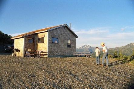
HARVEY WEST CABIN, California Campground Images, Info & Reservations
Listen Directions From Highway 50: Go approximately 32 miles east of Placerville or 25 miles west of South Lake Tahoe. Turn south on to Silver Fork Road 11N40. Travel approximately 2 miles on Silver Fork Road. Turn right into the China Flat Day Use parking area approximately 300′ feet past the China Flat Campground entrance. The Harvey West Cabin is located on the other side of the Silverfork American River. The combination for the bridge and the cabin will be given to you when you pick up your permit at the Placerville Ranger Station. The Placerville Ranger Station is on Highway 50 in Camino (8 miles east of Placerville). Take Exit 54 and go south on Eight Mile Road. The Ranger Station is the first driveway on your right. Phone 530-644-2324 Activities CAMPING, FISHING, HIKING, SWIMMING SITE Keywords HWCA,CHINA FLAT,SILVER FORK AREA,ELDORADO NF – FS Related Link(s) Rec Area Info
POSO GUARD STATION CABIN, California Campground Images, Info & Reservations
Listen Directions From Bakersfield, California, take Highway 65 north to Highway 155. Turn east on 155 and continue to the Jack Ranch Road. Turn left (north) and travel to the Old Stage Road (M3). Travel through the Balance Rock settlement until you come to a 4-way intersection. The driveway to Poso Cabin is a hard turn back to the left. From Porterville, travel south on Highway 65 to Ducor. Turn left (east) on Avenue 56 to Fountain Springs. At the 4-way stop, turn right onto Old Stage Road. Travel southeast to the intersection with the Jack Ranch Road. Turn left (north) on M3. Travel through the Balance Rock settlement until you come to a 4-way intersection. The driveway to Poso Cabin is a hard turn back to the left. Phone 760-376-1815 Activities BIKING, CAMPING, INTERPRETIVE PROGRAMS, FISHING, HIKING, WILDLIFE VIEWING Keywords POSO,SEQUOIA NF – FS Related Link(s) Rec Area Info
MOUNTAIN HOME GUARD STATION CABIN, California Campground Images, Info & Reservations
Listen Directions To reach the cabin from Porterville, take Highway 190 East to Springville. Turn left onto the Balch Park Road at the east end of Springville. You can either stay on this road all the way to the Cabin, or you can also take the Bear Creek Road, approximately 4 miles from the Highway 190 turn off. When the Bear Creek Road intersects with the Balch Park Road, turn left. Driving time from Springville on either route will take approximately an hour. Phone 559-539-5230 Activities BIKING, CAMPING, FISHING, HIKING, HUNTING Keywords MTHM,SEQUOIA NF – FS Related Link(s) Rec Area Info & Images California State Road Conditions Forest Service Concessionaire California State Tourism Overview The Mountain Home Guard Station not available for reservations. The Mountain Home Guard Station sits in a cluster of firs, pines and Giant Sequoia in the Sequoia National Monument in the Sequoia National Forest at an
BEAR BASIN LOOKOUT AND CABIN, California Campground Images, Info & Reservations
Listen Directions Note: Due to Road 17N05 being closed from damage this winter, all access must be obtained via South Fork Road and 16N02 over Ship Mountain. This route is approximately 2 hrs. one way. This is the only access to this facility at this time until road can be repaired. Approximately 18 miles of this route is not paved and has areas of washout. High clearance vehicles or 4×4 is advised. From Crescent City, head north on Highway 101 and turn right (east) on Hwy 199. Go throught the town of Hiouchi and turn right on county road 427 (South Fork Road) and continue driving 14 miles. Pavement ends and this road becomes Forest Service Road 16N02. Follow this road for 18 miles. You will see an access road (with a sign) on your left with a gate. Following the access road, it is 0.5 miles from the gate
WISHON CABIN, California Campground Images, Info & Reservations
Listen Directions From Porterville,California, take Highway 190 east. Continue through Springville for approximately 8 miles to Wishon Drive. Turn left and travel about 4 miles. The cabin is at the entrance to Wishon Campground on the right hand side of the road. From Bakersfield, California, take Highway 65 North to Highway 190 east and follow the directions above. Phone 559-539-5230 Activities BIKING, CAMPING, FISHING, HIKING, WILDLIFE VIEWING Keywords WISC,WISHON,SEQUOIA NF – FS Related Link(s) Rec Area Info & Images Forest Service Concessionaire California State Road Conditions California State Tourism Overview Wishon Cabin sits amid oaks and pines in the Southern Sierra Nevada Mountains in the Sequoia National Forest. The cabin, perched at an elevation of 3,900 feet, is located at the entrance of the Wishon Campground, about an hour drive from Springville, California. The cabin was originally built in the 1930s by the Civilian Conservation Corps and was used by
POST CREEK GUARD STATION, California Campground Images, Info & Reservations
Listen Directions From I-5, take California State Highway 36 West. From US-101 take California State Highway 36 East. Once on CA-36, there are two options. Option 1 is a bit longer but the majority of the trip is on paved Forest roads. Option 2 is shorter, but all of the trip is on gravel Forest roads. Call the Ranger Station before you go for more information on road conditions. DO NOT rely on any sort of GPS devices or online mapping programs to get you to Post Creek Guard Station. They are not accurate and may get you lost. There is no cell service at the cabin or on the roads leading to it. Make sure you have accurate directions before leaving home. Option 1 – From CA-36, turn south (left if coming from the east; right if coming from the west) onto Forest Road 30 (29N30), also known as
FOREST GLEN GUARD STATION, California Campground Images, Info & Reservations
Listen Directions Please note: Do NOT rely on GPS systems, particularly those on phones, as this can result in you being led off track onto Forest roads that cannot be traversed with all vehicle types. The cabin is off of a major Northern California Highway; there is no appropriate or direct route via gravel or dirt forest roads, except for the very short traverse to the cabin on the 1S26 Road directly off of CA-36. Coming from the south on I-5, take California State Highway 36 West at Red Bluff. Continue on CA-36 West for approximately 75 miles to Forest Glen. Pass Forest Glen Campground on the north (right), cross the South Fork Trinity River Bridge and turn south (left) directly after crossing the bridge onto Forest Road 1S26. Coming from the north on I-5, take either California State Highway 36 West (directions above) or California State Highway 299 West
SLY GUARD CABIN, California Campground Images, Info & Reservations
Listen Directions Sly Guard Cabin is located off U.S. Highway 50 in Pollock Pines, approximately 16 miles east of Placerville. Take Exit 60 (Sly Park Road) and travel south approximately 6.2 miles. Arrive at 5561 Sly Park Road on the left. Phone 530-644-2324 Activities BOATING, HISTORIC & CULTURAL SITE, CAMPING, HIKING, VISITOR CENTER Keywords Sly Park Lake Cabin,Jenkinson Lake Cabin,Sier Springs – Sly Park Cabin,Pollock Pines – Sly Park Cabin Related Link(s) Rec Area Info & Images California State Tourism California State Road Conditions Overview The Sly Guard Cabin is less remote than other cabins on the Eldorado National forest and is a great choice for families with children. Sly Guard provides the cabin in the woods experience with the convenience of modern amenities. The cabin is near Sly Park Reservoir, also called Jenkinson Lake, the tourist area of Apple Hill, a variety of wineries, a number of hiking trails,
CROCKER GUARD STATION, California Campground Images, Info & Reservations
Listen Directions From Portola, CA, travel east on Highway 70 for five miles to Beckwourth, CA. Travel north on County Road 111 (Beckwourth-Genesee Road) for six miles. Crocker Guard Station is on the left. Phone 530-832-1076 Activities CAMPING, FISHING, HIKING Keywords Related Link(s) Rec Area Info & Images California State Road Conditions California State Tourism Overview Crocker Guard Station was built in 1912 as a home for Forest Service personnel, and was later staffed as a fire station until the 1980s. The historic Crocker Guard Station is located ten miles northeast of Portola, California, at an elevation of 5,700 feet. Visitors will experience the beautiful solitude of the Eastern Sierra Nevada Mountains. Nearby recreational opportunities include fishing, boating, swimming and hiking. Recreation Crocker Campground is located adjacent to the Crocker Guard Station. This ten unit campground is free of charge and has tables, fire rings and vault toilets. The campground
Mountain cabin rentals are a form of glamping. This is a relatively new term that combines the words glamorous and camping. It is for folks that want the outdoor experience that comes with camping, but with more comfort. Learn about other forms of glamping here.