
Looking for a secluded cabin rental to use as a home base while exploring the scenic Utah outdoors? This page features 11 rustic & secluded cabins in scenic Utah.
Mountain biking and hiking are popular activities in the vicinity of these secluded cabins. In the winter, the surrounding area becomes a playground for snowmobile enthusiasts.
Be sure to click through on each secluded cabin rental below to read the full description before you reserve your spot. Access & amenities vary widely.
INDIAN CREEK GUARD STATION, Utah Campground Images, Info & Reservations
Listen Directions From Ferron, head west on West Canyon Road. Heading out of town, you will pass the golf course and Millsite Park. The pavement ends near the forest boundary. Stay on this road till you get to Ferron Reservoir, about 27 miles. Go to the left around the reservoir and you will see a sign for the guard station. From Mayfield, head east through Twelve Mile Canyon, on Forest Development Road 022. Near the top of the plateau, you’ll see Twelve Mile Flat Campground on the right. Across from the campground, make a left and continue on Forest Development Road 022, over the plateau and down the other side, about 3 miles. You’ll see the guard station on the left before you pass the reservoir. Phone 435-384-2372 Activities BIKING, BOATING, CAMPING, FISHING, HIKING, HUNTING, WILDLIFE VIEWING, SWIMMING SITE Keywords C057,Ferron Reservoir Guard Station Related Link(s) Rec Area Info &
SEELY CREEK GUARD STATION, Utah Campground Images, Info & Reservations
Listen Directions From Orangeville, travel west on State Highway 29 to Joe’s Valley Reservoir. At the reservoir, turn right and follow the road around to the other side. When you start heading away from the reservoir and toward the plateau, you’ll pass Orange Olsen Administrative Site on the right and then a road on the left. Do not turn. Continue on Highway 29, which is now a dirt road, and continues to the top of the plateau. (Warning: The road here gets narrow and when wet, can be extremely slick. Travelers may want to wait for it to dry especially if pulling a trailer). From where the road turns to dirt, it’s about 11 miles to the top. Just before you reach the top, look for Forest Road 050 and a sign on the left that says, "Seely Guard Station 2 miles." This will be within a quarter-mile of Skyline
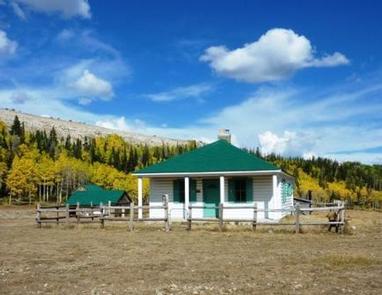
GOOSEBERRY ADMIN SITE CABINS, Utah Campground Images, Info & Reservations
Listen Directions From Salina, Utah, take I-70 eastbound about 7 miles to Gooseberry Road exit 63. Go south on County Road 640 for 10 miles to the Gooseberry Administrative Site on the right side of the road, just beyond Gooseberry Campground. Phone 435-896-9233 Activities CAMPING, FISHING, HORSEBACK RIDING, VISITOR CENTER, WILDLIFE VIEWING, DAY USE AREA Keywords GOSB,GOOSEBERRY RANGER STATION,GOOSEBERRY YCC CAMP,FISHLAKE NF – FS Related Link(s) Rec Area Info & Images Utah State Road Conditions Utah State Tourism Overview Gooseberry Administrative Site Cabins are located just 18 miles from Salina, Utah. These historic structures were used as Forest Service summer headquarters from 1907 to 1960. Today, the site is used for family reunions, group events, scout and church groups and youth camps. Recreation Popular activities in the area include off-road vehicle riding, fishing, hiking, biking, horseback riding and wildlife watching. The Great Western Trail runs nearby; two trailheads can be
COLTON GUARD STATION, Utah Campground Images, Info & Reservations
Listen Directions Follow the mileage indications below and look for signs when traveling to Colton Guard Station. Leave with plenty of time to arrive at the guard station before dark. From Vernal, travel north on U.S. Highway 191/Vernal Avenue for approximately 20 miles. Turn left (west) on Forest Road 020. A paved parking lot with a restroom is located at the intersection. Continue northwest on the paved Forest Road 020 for approximately two miles. Turn left (southwest) at Forest Road 019 and continue for less than a mile, reaching an intersection (Forest roads 028 and 019). Turn left, continuing south on Forest Road 019. Continue approximately 1.75 miles, where the road turns sharply to the right (west). Follow the hairpin turn down into a ravine to Colton Guard Station. Phone 4357891811 Activities BIKING, CAMPING, HIKING, WINTER SPORTS, WILDLIFE VIEWING Keywords COLT,COLTON RANGER STATION,COLTON CABIN,COLTON HOLLOW,ASHLEY NF – FS Related Link(s)
PARADISE GUARD STATION, Utah Campground Images, Info & Reservations
Listen Directions Follow the mileage indications below and look for signs on the ground when traveling to Paradise Guard Station. Leave with plenty of time to arrive at the guard station before dark. From Vernal, travel west on Highway 121/Maeser-Lapoint Highway, toward Lapoint. After passing the landfill and descending the hill along the curved road, some houses come into view. While approaching Deep Creek Road, look for brown signs to Paradise Park Reservoir. Turn right (north) at Deep Creek Road (approximately 12.5 miles west of the Dry Fork Canyon Road junction with Highway 121). Continue north on Deep Creek Road for nearly 7 miles and watch for a fork in the road. Turn left (northwest) onto Paradise Park Road and continue approximately 8.5 miles, reaching the Ashley National Forest boundary. The paved road ends and turns to an unsurfaced road at the cattle guard. Paradise Park Road becomes Forest Road
COWPUNCHER GUARD STATION, Utah Campground Images, Info & Reservations
Listen Directions From Highway 12 in Escalante, turn north on 300E. Drive 14 miles to the junction of Forest Roads 154 and 153. Continue on FR153 for 4.5 miles. Turn left on FR145 towards Cowpuncher and Blue Spruce Campground. Travel 0.7 miles to Cowpuncher Gate. The cabin is 0.2 miles past the gate. Phone 435-826-5499 Activities FISHING, HIKING Keywords COWP,DIXIE NF – FS,COWPUNCHER GUARD STATION,COWPUNCHER CABIN,COWPUNCHER YURT,COWPUNCHER,COWPUNCHER GUARD STATION YURT Related Link(s) Rec Area Info & Images Utah State Road Conditions Utah State Tourism Overview Cowpuncher Guard Station is located in the Dixie National Forest, 20 miles northeast of the town of Escalante in southern Utah. The cabin is situated just off the Hells Backbone Road and is accessed by road during summer and fall. Roads are usually closed by snow 5.5 miles from the cabin from late November to mid-April. Check the ranger station for winter conditions. Recreation The
JONES CORRAL GUARD STATION, Utah Campground Images, Info & Reservations
Listen Directions From State Highway 89, turn east onto State Highway 62 and travel about 12 miles, where it turns into State Highway 22 just north of Antimony. In this town, Forest Road 126 will be found on the west side of the road. Travel along this high-clearance dirt road about 12 miles to reach Jones Corral Guard Station. From Bryce Canyon National Park, travel north on State Highway 22 approximately 35 miles to Antimony. In this town, Forest Service Road 126 will be found on the west side of the highway. Travel along this high-clearance dirt road about 12 miles to Jones Corral Guard Station. Phone 435-676-9300 Activities BIKING, CAMPING, HIKING, HORSEBACK RIDING, HUNTING, WILDLIFE VIEWING Keywords JOGS,DIXIE NF – FS Related Link(s) Rec Area Info & Images Utah State Road Conditions Utah State Tourism Overview Jones Corral Guard Station is located on the Dixie National Forest, 12 miles
PINE VALLEY GUARD STATION, Utah Campground Images, Info & Reservations
Listen Directions From Exit 6 in St. George, Utah, turn north onto Bluff Street, which turns into Utah Highway 18 North; continue to follow for 27 miles. Turn east onto Pine Valley Highway and travel 6.9 miles into Pine Valley. From the Pine Valley stop sign, turn east onto Main Street and follow 2 miles to the Pine Valley Recreation Area. The Guard Station is located a quarter mile past the reservoir parking lot on the north side of the road. During winter months, there is a 1.5 mile cross-country ski, snowshoe or walk into the cabin from the winter trailhead at the entrance to the Pine Valley Recreation Area. Phone 435-652-3100 Activities BIKING, CAMPING, HIKING, WINTER SPORTS, WILDLIFE VIEWING, BIRDING, CROSS COUNTRY SKIING, AMPHITHEATER, SNOWSHOEING Keywords None Related Link(s) Rec Area Info & Images Utah State Tourism Utah State Road Conditions Overview Pine Valley Guard Station is located in
BLACKSMITH FORK GUARD STATION, Utah Campground Images, Info & Reservations
Listen Directions From Logan, Utah, drive south on US 89 for approximately 1 mile then merge left onto State Route 165. Travel south for about 5.8 miles then turn left onto State Route 101 and follow it east up Blacksmith Fork Canyon for approximately 9 miles. Turn left into Left Hand Fork Canyon and travel approximately 3 miles on the improved gravel road to the Guard Station. Phone 435-755-3620 Activities BIKING, CAMPING, FISHING, HIKING, HORSEBACK RIDING, HUNTING Keywords Left Hand Fork Guard Station Related Link(s) Rec Area Info & Images Utah State Tourism Utah State Road Conditions Overview Blacksmith Fork Guard Station is located in the Cache National Forest, approximately 11 miles east of Hyrum, in northern Utah. The Guard Station was constructed by the Civilian Conservation Corps in 1934 as part of the New Deal Program. Early Forest Service stations were typically spaced a "days ride by horseback" from
PAYSON LAKES GUARD STATION, Utah Campground Images, Info & Reservations
Listen Directions From I-15, take exit 250 toward north Payson/Salem and proceed south on Main Street to 100 North/Highway 198. Travel east to 600 East. Turn south onto 600 East, which becomes the Nebo Loop Scenic Byway/Payson Canyon Road. Travel south along the Nebo Loop Road 015 until you see the Payson Lakes Guard Station sign on the right. Proceed up the driveway and through the gate. Phone SPANISH FORK RANGER DISTRICT 801-798-3571 OR UTAH RECREATION COMPANY 385-273-1100 Activities BIKING, HISTORIC & CULTURAL SITE, CAMPING, FISHING, HIKING, HORSEBACK RIDING, HUNTING, WILDLIFE VIEWING, SCENIC DRIVE Keywords Related Link(s) Rec Area Info & Images Utah State Road Conditions Utah State Tourism Overview Payson Lakes Guard Station is located in the Uinta National Forest, approximately 13 miles south of Payson, Utah, along the Mount Nebo Scenic Byway. The Guard Station was constructed by the Civilian Conservation Corps in 1935 as part of the
MAMMOTH CABIN, Utah Campground Images, Info & Reservations
Listen Directions From Fairview, Utah, for 8.5 miles proceed east on Utah Highway 31. Then turn east (left) to Utah highway 264 for .2 miles, then turn left (north) through the paved parking lot to the gravel road, then right (FS road 0124 downhill). You will pass the Gooseberry Campground sign, at the next intersection (FS road 0124) make a slight left and proceed through the gate. The Mammoth Cabin is first, the Lake Cabin is the third building. From US Highway 6 take Utah Highway 96 south through Scofield then onto Utah 264 west for 15 miles. Prior to the junction of Utah 31 and Utah 264 there is a large paved parking lot. Turn north and proceed to the gravel road, then right (FS road 0124 downhill). You will pass the Gooseberry Campground sign, at the next intersection (FS road 0124) make a slight left and proceed through
Rustic & secluded cabin rentals are a form of glamping. This is a relatively new term that combines the words glamorous and camping. It is for folks that want the outdoor experience that comes with camping, but with more comfort. Learn about other forms of glamping here.