
Discover the very best that scenic Alaska has to offer with these 147 rustic & secluded cabin rentals. Experience Alaska from the comfort of a rustic cabin, no tent to setup, just show up and enjoy!
This page features 147 rustic & secluded cabins in the amazing Alaska outdoors.
Be sure to click through on each secluded cabin rental below to read the full description before you reserve your spot. Access & amenities vary widely.
DEEP BAY CABIN, Alaska Campground Images, Info & Reservations
Listen Directions Deep Bay Cabin is located on the south end of Deep Bay on the northeast corner of Zarembo Island. The cabin is a short walk from Deep Bay and about 1/4 mile from Roosevelt Harbor just off of the Zarembo Beach Road FSR 6590. The cabin is only accessible by boat or float plane, about 15 miles from Wrangell. There is a float dock, ramp, and parking area at Roosevelt Harbor. Use caution when anchoring a boat due to the rocky shoreline. Check local tide tables to determine the best time for arrival and departure. Phone 907-874-2323 Activities BIKING, BOATING, CAMPING, FISHING, HIKING, HUNTING, OFF HIGHWAY VEHICLE, WILDLIFE VIEWING Keywords Related Link(s) Rec Area Info & Images Alaska State Tourism Alaska State Road Conditions Overview The Deep Bay Cabin is a fully ADA accessible, large group recreation cabin located on Zarembo Island. It is popular for hunting and
White Mountains National Recreation Area – Alaska Cabins, Alaska Campground Images, Info & Reservations
Listen Directions Traveling north from Fairbanks, take the Steese Highway on through Fox. There is a trailhead at Milepost 42 and 57 of the Steese Highway to access some of the cabins. Traveling north on the Elliott Highway from Fox, there are two trailheads at Milepost 28 and 57 of the Elliott Highway to access the White Mountains from the west side. For further information contact BLM district office. Phone (907)-474-2200 Activities CAMPING, HIKING, HORSEBACK RIDING, HUNTING, WINTER SPORTS, WILDLIFE VIEWING Keywords Related Link(s) Rec Area Info & Images Alaska State Road Conditions Alaska State Tourism Overview Located just an hour’s drive from Fairbanks, Alaska, the one-million-acre White Mountains National Recreation Area offers stunning scenery, peaceful solitude and outstanding opportunities for year-round recreation including hiking, snowmobiling, snowshoeing, skiing, wildlife and scenic viewing. There are 12 beautiful log cabins throughout the White Mountains offering many opportunities to enjoy the outdoors. Be
Kenai Fjords National Park Cabins, Alaska Campground Images, Info & Reservations
Listen Directions The cabins are accessible only by float plane or boat. Holgate Cabin: 59° 50′ 01.61" N 149° 46′ 10.25" W Aialik Bay Cabin: 59° 53′ 12.63" N 149° 39′ 22.41" W Phone (907)422-0500 Activities CAMPING, FISHING, WILDLIFE VIEWING Keywords Related Link(s) Rec Area Info & Images Alaska State Road Conditions Alaska State Tourism Overview Holgate and Aialik Bay Cabins are rustic public use cabins. The cabins are accessible only by a two-hour boat ride or a 30-minute float plane flight from Seward; there are no roads to the cabins. The cabins are open from Memorial Day Weekend to Labor Day Weekend and booking starts January 3rd. Holgate Cabin is located on the northeastern shore of Holgate Arm in Aialik Bay. The cabin sits on a small bluff above a cobble beach. There are spectacular views of Holgate Glacier from the cabin’s front porch. Aialik Bay Cabin is located
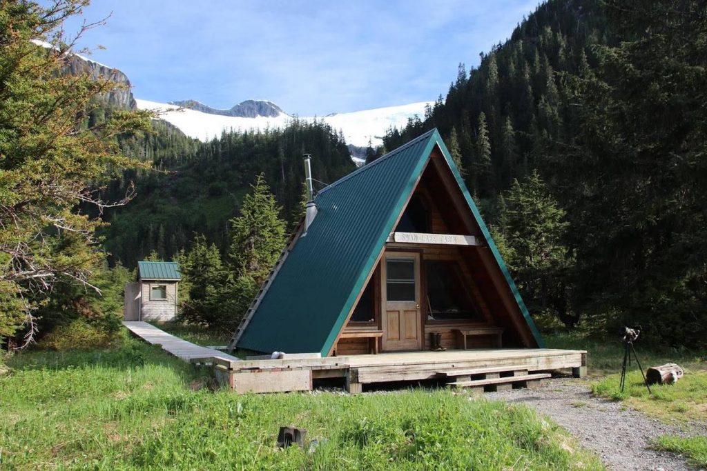
SPENCER BENCH CABIN, Alaska Campground Images, Info & Reservations
Listen Directions To catch the train (reservations required) into the Spencer Whistle Stop, drive south from Anchorage on the Seward Highway to the Portage Rail Depot (Milepost 80) and check in at the Train station. In the winter months there are 2 snowmachine parking lots at Seward Highway Milepost 78 where snowmachines can access the Cabin by heading up the Placer River Valley. Note: Over snow access is condition dependent. Please call the Glacier Ranger District office (907-783-3242) for info on access via snowmachine. Phone WINTER 907-783-3242 SUMMER 800-544-0552 Activities CLIMBING, CAMPING, FISHING, HIKING, WILDLIFE VIEWING, MOUNTAIN BIKING Keywords Related Link(s) Rec Area Info & Images Alaska State Road Conditions Alaska State Tourism Overview Spencer Bench Cabin is located at 1,900 feet in elevation at the end of the Spencer Bench Trail, climbing away from the lake revealing breathtaking views of the Placer River Valley, Spencer Lake and the Spencer
SKATERS CABIN SHELTER, Alaska Campground Images, Info & Reservations
Listen Directions This Skater’s Cabin Shelter is approximately 13 miles from downtown Juneau. Access is via the Alaska Marine Highway or via Alaska Airlines. By ferry: Turn right out of the Ferry Terminal parking lot. Drive 1.7 miles to DeHart’s Store above Auk Bay marinas. Take a left turn onto Back Loop Road. Travel 2.5 miles to Montana Creek Road. Turn left onto Montana Creek Road. Drive 0.4 miles to Skater’s Cabin Shelter. The shelter is just past the Mendenhall Lake Campground entrance. From the airport: Go 0.1 mile to the junction of Yandukin Shell Simmons Drive. Turn left on Shell Simmons Drive and travel 0.3 miles to stoplight at the intersection of Old Glacier Highway. Turn left on Old Glacier Highway and travel 0.5 mile to the stoplight at the intersection of Egan Drive. Continue straight onto Mendenhall Loop Road 2.2 miles to the intersection of Back Loop Road.
KENNEL CREEK CABIN (AK), Alaska Campground Images, Info & Reservations
Listen Directions Kennel Creek Cabin is located approximately 19 air miles southeast of the City of Hoonah, Alaska on the south shore of Freshwater Bay. Access is by vehicle, float plane, or boat. Total distance by gravel road is approximately 27 miles. By road travel south from Hoonah past the airport. Where the road turns to gravel, drive 2 miles to the T intersection, turn right toward Freshwater Bay. Drive 25 miles on National Forest System road 8502/8508, veer left at all Y intersections. The cabin is located at the end of a short access road on your left. Road maps are avaliable at the Hoonah Ranger District office during weekday business hours. Phone 907-945-3631 Activities AUTO TOURING, BOATING, CAMPING, FISHING, HUNTING, PICNICKING, WILDLIFE VIEWING, PHOTOGRAPHY, MOTOR BOAT, SNOWMOBILE, BERRY PICKING, BEACH CAMPING, BEACHCOMBING, SEA KAYAKING, BIRDING, WHALE WATCHING, SNOWSHOEING, WOOD CUTTING Keywords Freshwater Bay Cabin,Kennel Creek,Kennel Creek Spit,Hoonah Cabin,Chichigof
MIDDLE RIDGE CABIN, Alaska Campground Images, Info & Reservations
Listen Directions Middle Ridge Cabin is located on Wrangell Island, approximately 20 miles from Wrangell, Alaska. There are no roads to Wrangell. Access is by the Alaska Marine Highway or via Alaska Airlines. From Wrangell, head south on Zimovia Highway approximately 11 miles to Pat’s Creek Road (Road 6259) and take a left. Follow road approximately 4 miles to its junction with Road 50054 and turn right. From this point on, the road becomes steep, exceeding grades of 15 percent, with sharp switchbacks and limited turnouts. Follow Road 50054 about 1.5 miles to its junction with Road 50060, making a sharp right. Stay on Road 50060 for the remaining distance. The cabin is located near the end of Road 50060. Snow can block vehicle access as late as early-June and as early as mid-October in some years. When the road is clear of snow, vehicle access is approximately 20 miles
Kodiak National Wildlife Refuge Cabins, Alaska Campground Images, Info & Reservations
Listen Directions There are no roads or maintained trails in Kodiak National Wildlife Refuge. All cabins are accessible by float plane. Blue Fox Bay, Uganik Island, and Viekoda Bay are also accessible by boat. Refuge employees cannot assist in making travel arrangements, but can provide a current list of charter operators permitted to transport customers into the refuge. To obtain this list please contact the refuge headquarters at (888) 408-3514. Phone 1-888-408-3514 Activities BOATING, CAMPING, FISHING, HIKING, HUNTING, WILDLIFE VIEWING Keywords KODIAK NATIONAL WILDLIFE REFUGE,KNWR Related Link(s) Rec Area Info & Images Kodiak Tides Seldovia Tides Alaska State Road Conditions Alaska State Tourism Overview Kodiak National Wildlife Refuge is known world-wide for its iconic wildlife. Visitors journey here to view Kodiak brown bears and majestic bald eagles, fish for all five species of Pacific salmon, hunt big game, watch marine life, and plenty of other wildlife related activities. The refuge
Eight Fathom Cabin, Alaska Campground Images, Info & Reservations
Listen Directions Eight Fathom Cabin is located 15 miles southwest of the City of Hoonah, Alaska on the north shore of Eight Fathom Bight at the head of Port Frederick. Access is by float plane or boat only. It is a 45-minute boat ride from Hoonah and approximately a 30-minute flight from Juneau, AK. Flight time from Hoonah is less than 10-minutes. The cabin is at the south end of the isolated Eight Fathom National Forest System road 8580 and within half a mile from the Eight Fathom Marine Access Facility (MAF) float dock. This road system is not connected to the Hoonah Road System and the dock is only accessible by float plane or boat. Please consult local tide tables before departing for the cabin. Once ashore, the cabin is accessed via a short 125-ft barrier free trail. Phone (907) 945-3631 Activities BIKING, BOATING, CAMPING, FISHING, HIKING, HUNTING, PICNICKING,
KENAI NATIONAL WILDLIFE REFUGE CABINS, Alaska Campground Images, Info & Reservations
Listen Directions Access to each individual cabins varies. Some can be reached by hiking-in, while others require a boat or plane to access . In winter, a snowmachine may be necessary. Please refer to each specific cabin for information on amenities and accessibility. Kenai National Wildlife Refuge: From Anchorage, take the Seward Highway south to the Sterling Highway; the eastern refuge boundary is at milepost 55 of the Sterling Highway. Another 5 miles from the boundary is the west entrance to the Skilak Wildlife Recreation Area. Continuing on to Soldotna will bring you to the refuge visitor center and headquarters, which is found by taking a left onto Funny River Road, then turning right (before the building supply store) onto Ski Hill Road. Phone (907) 262-7021 Activities CAMPING Keywords Kenai National Wildlife Refuge,Big Indian Creek Cabin,Caribou Island Cabin,Dolly Varden Lake Cabin,Doroshin Bay Cabin,Engineer Lake Cabin,Kelly Lake Cabin,McLain Lake Cabin,Nurses Cabin,Pincher
STARRIGAVAN CREEK CABIN, Alaska Campground Images, Info & Reservations
Listen Directions Located 7 miles northeast of Sitka at the end of Halibut Point Road, about 3/4 mile from the local Alaska Marine Highway ferry terminal. There are no roads to Sitka. Access is via the Alaska Marine Highway or Alaska Airlines. Upon exiting the Ferry Terminal parking lot, turn left. Drive 3/4 mile on the state highway, also known as Halibut Point Road, or walk the same distance on the separate pedestrian walkway. The Estuary Loop, where this cabin is located (in Campsite 6), is accessed from the last right turn before the end of the state highway. From the airport, go across the O’Connell Bridge through downtown Sitka to the intersection of Sawmill Creek Road and Halibut Point Road, which is a roundabout. Turn onto Halibut Point Road and travel 7 miles north to Starrigavan Recreation Area. Phone 907-747-6671 Activities BIKING, BOATING, CAMPING, FISHING, HIKING, WILDLIFE VIEWING Keywords
Priest Rock Cabin, Alaska Campground Images, Info & Reservations
Listen Directions The cabin is 120 air miles from Anchorage and 8 miles from Port Alsworth. Visitors must arrange their own transportation. This cabin is accessible by float plane, water taxi, or private vessel. Kayakers with advanced skills can reach the cabin from Port Alsworth. There are no mooring buoys at this location. Phone 907-781-2218 Activities BOATING, CAMPING, FISHING, WILDLIFE VIEWING Keywords Allen Woodward Cabin,Woodward Cabin Related Link(s) Rec Area Info & Images Alaska State Road Conditions Alaska State Tourism Overview Take yourself back in time with a stay in the Priest Rock Cabin on Lake Clark. Split some wood and head inside to light a blaze in the wood stove, under the light of the moon as it shimmers on the lake. Enjoy the warmth as your gear dries out from a day on the water. Recreation The cabin is an ideal location for kayaking, boating, fishing and wildlife
SALMON LAKE CABIN SITKA, Alaska Campground Images, Info & Reservations
Listen Directions Accessible nearly year round, depending on mode of access. Located 11 miles southeast of Sitka on Baranof Island, approximately 10 minutes by floatplane. Access by boat from Sitka to Silver Bay is 10 miles, and a 2-mile trail leads to the cabin. Trail begins near mooring buoy at the end of Silver Bay. Plan arrival and departure during high tide, unload gear at east shore at estuary head, then tie up boat at mooring buoy. Please consult local tide tables before departing for the cabin. For geographic features surrounding the cabin, refer to USGS topographic map Port Alexander D-4 and Sitka A-4. Phone 907-747-6671 Activities CAMPING, FISHING, HIKING, HUNTING Keywords SALA,TONGASS NF – FS Related Link(s) Rec Area Info & Images Alaska State Tourism Alaska State Road Conditions Overview Salmon Lake Cabin sits on the east shore of Salmon Lake on Baranof Island, 11 miles southeast of Sitka,
ALSEK RIVER CABIN, Alaska Campground Images, Info & Reservations
Listen Directions This cabin is located 55 miles southeast of Yakutat, just north of Alsek River. Access is by wheeled plane only, on an 1,800×50-ft. airstrip. Phone (907) 784-3359 Activities CAMPING, HUNTING, WILDLIFE VIEWING Keywords ALSE,TONGASS NF – FS Related Link(s) Rec Area Info & Images Alaska State Tourism Alaska State Road Conditions Overview Alsek River Cabin is located on the Yukutat Forelands about a mile from the Alsek River, a large river known for its many glaciers. This cabin is open year-round and offers relaxation as well as excellent hunting opportunites. The site can be accessed by wheeled plane, depending on conditions. An airstrip is adjacent to the cabin. Guests are responsible for their own travel arrangements and safety, and must bring several of their own amenities. Recreation Moose hunting is available in the surrounding area, and mountain goat hunting is excellent in the Brabazon Range 2 miles to
MIDDLE DANGEROUS RIVER CABIN, Alaska Campground Images, Info & Reservations
Listen Directions The cabin is located 30 miles southeast of Yakutat, 200 feet east of Dangerous River. Access is by jetboat or a 4-mile ATV trail from the Dangerous River Bridge at the end of Forest Highway 10. Phone (907) 784-3359 Activities BOATING, CAMPING, HIKING, HUNTING, WILDLIFE VIEWING Keywords MIDR,TONGASS NF – FS Related Link(s) Rec Area Info & Images Alaska State Tourism Alaska State Road Conditions Overview Middle Dangerous River Cabin is situated on the bank of the Dangerous River about 30 miles southeast of Yakutat. This remote retreat is open year-round, offering scenic views, wildlife watching and hunting opportunities. The site can be accessed by jetboat, hiking or ATV aong thel 4-mile trail from the Dangerous River Bridge. Visitors are responsible for their own travel arrangements, and must bring several of their own amenities. Recreation The Dangerous River is a large glacial river with numerous logjams, sandbars and
ANAN LAKE CABIN, Alaska Campground Images, Info & Reservations
Listen Directions The cabin is on the south end of Anan Lake, which is on the mainland (231′ elevation) above Anan Bay. This cabin is accessible by float plane only, and is 31 miles by air from Wrangell. The lake is normally ice-free May through October. At other times, ice may prevent float planes from landing. Please check local conditions in advance by calling (907) 874-2323. Phone 907-874-2323 Activities CAMPING, FISHING, HIKING, WILDLIFE VIEWING Keywords ANKE,TONGASS NF – FS Related Link(s) Rec Area Info & Images Alaska State Road Conditions Alaska State Tourism Overview A stay at Anan Lake Cabin provides for a unique experience at a remote, backcountry lake only accessible by floatplane. The cabin sits on the mainland above Anan Bay at the south end of Anan Lake. Visitors are responsible for their own travel arrangements and safety, and must bring several of their own amenities. Recreation Boulder
EAGLE LAKE CABIN, Alaska Campground Images, Info & Reservations
Listen Directions The cabin is located southeast of Wrangell, on the east shore of Eagle Lake. The lake is on the mainland south of Bradfield Canel (at an elevation of about 300 feet) and is about 44 miles by air from Wrangell. This cabin is accessible by float plane only. The lake is normally ice free from May to October. In the fall, winter, and early spring, the cabin may be inaccessible due to frozen lake surface (float planes cannot land). Please check local conditions in advance by calling (907) 874-2323. Phone 907-874-2323 Activities CAMPING, FISHING, HUNTING Keywords EAGK,TONGASS NF – FS Related Link(s) Rec Area Info & Images Alaska State Road Conditions Alaska State Tourism Overview A stay at Eagle Lake Cabin provides for a uniquely Alaskan experience at a remote, fly-in only lake. Eagle Lake is 44 air miles south of Wrangell, Alaska, and recognized as a trophy
MALLARD SLOUGH CABIN, Alaska Campground Images, Info & Reservations
Listen Directions Mallard Slough Cabin is on the mainland between LeConte Bay and the North Arm of the Stikine River, on the Stikine River delta in the Stikine-LeConte Wilderness. This cabin is accessible by shallow draft boat or float plane, 18 miles by air or 20-22 miles by boat from Wrangell or Petersburg. Tides affect access to this cabin; please consult local tide tables . Access generally requires a high tide of 14 feet or higher for shallow draft boat, or 16 feet or higher for a float plane. Phone 907-874-2323 Activities BOATING, CAMPING, HIKING, HUNTING, WILDLIFE VIEWING, PADDLING, BIRDING Keywords MASL,TONGASS NF – FS Related Link(s) Rec Area Info & Images Alaska State Tourism Alaska State Road Conditions Overview Mallard Slough Cabin provides an excellent basecamp for exploration of the Stikine River Delta and Stikine-LeConte Wilderness. The surrounding area offers opportunities for hiking, paddling, hunting and birdwatching. The cabin
GUT ISLAND 2 CABIN, Alaska Campground Images, Info & Reservations
Listen Directions The Gut Island Cabins are located on Gut Island, adjacent to the western tip of Farm Island on the Stikine River delta in the Stikine-LeConte Wilderness. The cabin is 12 miles by float plane or shallow draft boat from Wrangell, or 7 miles from the boat ramp on the south end of Mitkof Island. Tides affect access to the cabin. Boat access generally requires a tide of 15 feet, while planes require a tide of 17 feet or higher. It is a short walk to the cabin from the anchorage point. Please consult local tide tables before arrival and departure. Phone 907-874-2323 Activities BOATING, CAMPING, HUNTING, WILDLIFE VIEWING, PADDLING, BIRDING Keywords GUTD,GUT ISLAND 2 CABIN,TONGASS NF – FS Related Link(s) Rec Area Info & Images Alaska State Tourism Alaska State Road Conditions Overview The Gut Island Cabins provide a basecamp for exploring the Stikine River tideflats. The tideflats
HARDING RIVER CABIN, Alaska Campground Images, Info & Reservations
Listen Directions Located southeast of Wrangell on the mainland at the mouth of the Harding River, which is on the north side of the Bradfield Canal. Distance is 31 miles by air, 40 miles by boat from Wrangell. The beach near the cabin slopes gradually and does not provide for easy boat anchorage. Anchoring the boat in deeper water is recommended, and using a skiff or punt between the boat and shore. Phone 907-874-2323 Activities BOATING, CAMPING, FISHING, HUNTING, WILDLIFE VIEWING Keywords HARI,TONGASS NF – FS Related Link(s) Rec Area Info & Images Alaska State Road Conditions Alaska State Tourism Overview Harding River Cabin is located in the Bradfield Canal near excellent fishing and crabbing spots. It is also in a prime spot for viewing birds and wildlife. The site can be accessed by float plane or boat, depending on conditions. Boats and planes should anchor in deeper water, and
SITUK LAKE CABIN, Alaska Campground Images, Info & Reservations
Listen Directions The cabin is located 14 miles northeast of Yakutat on the eastern shore of Situk Lake. Access is by trail or floatplane. Please contact the Yakutat Ranger District for information at (907) 784-3359 prior to making reservations during these periods. The Situk Lake Trail starts at the end of East Gate Road and is 3 miles to the cabin. The trail can be very wet. Phone (907) 784-3359 Activities BOATING, CAMPING, FISHING, HIKING, HUNTING, WILDLIFE VIEWING Keywords SITU,TONGASS NF – FS Related Link(s) Rec Area Info & Images Alaska State Tourism Alaska State Road Conditions Overview Situk Lake Cabin is located 14 miles northeast of Yakutat. It is situated on the eastern shore of Situk Lake, within the Russell Fjord Wilderness. The cabin is open for year-round enjoyment, offering opportunities for recreation and wildlife watching. The site can be accessed by floatplane or by hiking forest service maintained
EAGLE CABIN, Alaska Campground Images, Info & Reservations
Listen Directions The cabin is located 8 air miles east of Yakutat on the east bank of Situk River. Access is by trail, boat or wheeled aircraft. From Nine Mile Bridge on Forest Highway 10, hike the 3-mile trail or boat 3.2 miles downriver (1.5 hour float). The cabin 9.6 miles upriver from Situk Landing (terminus of Lost River Road). The Forest Service-maintained airstrip is about 300 feet from cabin. It is 1,800 feet long and 50 feet wide. Phone (907) 784-3359 Activities BOATING, CAMPING, FISHING, HIKING, HUNTING, WILDLIFE VIEWING Keywords EAGE,MIDDLE SITUK NORTH CABIN,TONGASS NF – FS Related Link(s) Rec Area Info & Images Alaska State Tourism Alaska State Road Conditions Overview Eagle Cabin, formerly known as Middle Situk North Cabin, is located on the east bank of the Situk River. It is open year-round and makes an ideal base for fishing or hunting. The site can be accessed
RAVEN CABIN, Alaska Campground Images, Info & Reservations
Listen Directions The cabin is located 8 air miles east of Yakutat on the east bank of Situk River. Access is by trail, boat or wheeled aircraft. From Nine Mile Bridge on Forest Highway 10, hike the 3-mile trail or boat 3.2 miles downriver (1.5 hour float). The cabin is 9.6 miles upriver from Situk Landing (terminus of Lost River Road). The Forest Service-maintained airstrip is about 300 feet from cabin. It is 1,800 feet long and 50 feet wide. Phone 907-784-3359 Activities BOATING, CAMPING, FISHING, HIKING, HUNTING, WILDLIFE VIEWING Keywords RAVE,MIDDLE SITUK SOUTH CABIN,TONGASS NF – FS Related Link(s) Rec Area Info & Images Alaska State Road Conditions Alaska State Tourism Overview Raven Cabin, formerly known as Middle Situk South Cabin, is located on the east bank of the Situk River. It is open year-round and makes an ideal base for fishing or hunting. The site can be accessed
TANIS MESA NORTH CABIN, Alaska Campground Images, Info & Reservations
Listen Directions The cabin is located 50 miles southeast of Yakutat between Tanis Mesa and Brabazon Mountain Range. Access is by wheeled plane only via an 1,800-ft. airstrip at the cabin. Phone (907) 784-3359 Activities CAMPING, HIKING, HUNTING, WILDLIFE VIEWING Keywords TANI,TONGASS NF – FS Related Link(s) Rec Area Info & Images Alaska State Road Conditions Alaska State Tourism Overview Tanis Mesa North Cabin is located in a duplex with Tanis Mesa South Cabin. The cabin is tucked between Tanis Mesa and the Brabazon Mountain Range, offering year-round relaxation and recreation. The site can be accessed by wheeled plane, depending on conditions. An airstrip is adjacent to the cabin. Visitors are responsible for their own travel arrangements and safety, and must bring several of their own amenities. Recreation Tanis Lake is 2 miles north of the cabin and can be hiked to relatively easily except for the last quarter mile,
TANIS MESA SOUTH CABIN, Alaska Campground Images, Info & Reservations
Listen Directions The cabin is located 50 miles southeast of Yakutat between Tanis Mesa and Brabazon Mountain Range. Access is by wheeled plane only via an 1,800-ft. airstrip at the cabin. Phone (907) 784-3359 Activities CAMPING, HIKING, HUNTING, WILDLIFE VIEWING Keywords TANS,TONGASS NF – FS Related Link(s) Rec Area Info & Images Alaska State Tourism Alaska State Road Conditions Overview Tanis Mesa South Cabin is located in a duplex with Tanis Mesa North Cabin. The cabin is tucked between Tanis Mesa and the Brabazon Mountain Range, offering year-round relaxation and recreation. The site can be accessed by wheeled plane, depending on conditions. An airstrip is adjacent to the cabin. Visitors are responsible for their own travel arrangements and safety, and must bring several of their own amenities. Recreation Tanis Lake is 2 miles north of the cabin and can be hiked to relatively easily except for the last quarter mile,
ITALIO RIVER CABIN, Alaska Campground Images, Info & Reservations
Listen Directions Located 30 miles SE of Yakutat, the cabin is on the west bank of Hooligan Creek, a half-mile from the Old Italio River. Access is by wheeled plane on a tidal flat airstrip. The 1,600×100-ft. airstrip may flood at extreme high tides or after heavy rains. Please consult tide charts in advance, since tides can affect access to this cabin. Phone (907) 784-3359 Activities CAMPING, FISHING, HUNTING, WILDLIFE VIEWING Keywords ITAL,TONGASS NF – FS Related Link(s) Rec Area Info & Images Alaska State Road Conditions Alaska State Tourism Overview Italio River Cabin is situated on the west bank of Hooligan Creek about half a mile from the Old Italio River and the Gulf of Alaska. This remote retreat is open year-round and makes an ideal base for fishing or hunting trips. The site can be accessed by wheeled plane, depending on conditions. The nearby airstrip is on tidal
MOSER ISLAND CABIN, Alaska Campground Images, Info & Reservations
Listen Directions Accessible year round, weather permitting. Located 48 air miles north of Sitka, within Hoonah Sound on the north end of Moser Island, north of Peril Strait. Access from Sitka is 30 minutes by floatplane, or 2 hours by boat. For geographic features surrounding the cabin, refer to USGS topographic map Sitka C-6. Please consult local tide tables before departing for the cabin. Phone 907-747-6671 Activities CAMPING, FISHING, HIKING, HUNTING, WILDLIFE VIEWING Keywords MOSE,TONGASS NF – FS Related Link(s) Rec Area Info & Images Alaska State Road Conditions Alaska State Tourism Overview Moser Island Cabin sits on the northern shore of Moser Island in upper Hoonah Sound, 48 miles north of Sitka, Alaska. The wood cabin, built in 1991 by volunteers from Sitka, is available year-round and makes an excellent base for experiencing and exploring this corner of Alaska. This is a remote site. The cabin can be accessed
APPLETON COVE CABIN, Alaska Campground Images, Info & Reservations
Listen Directions Accessible from Sitka year round, weather permitting. 30 air miles or 50 boat miles north of Sitka on Baranof Island just south of Peril Strait on the southeast shore of Appleton Cove. Access from Sitka, 25 minutes by float plane or 2 hours by boat. Occasionally winter temperatures can freeze the cove, preventing access during those times. For geographic features surrounding the cabin, refer to USGS topographic map Sitka B-4. Phone 907-747-6671 Activities CAMPING, FISHING, HIKING, HUNTING, WILDLIFE VIEWING Keywords APPL,TONGASS NF – FS Related Link(s) Rec Area Info & Images Alaska State Road Conditions Alaska State Tourism Overview Appleton Cove Cabin was built in 1992 by Forest Service administrative crews for field housing during a period of logging. When logging was complete, the cabin became available for recreation. The cabin is open year-round and makes an excellent base for visitors looking to enjoy saltwater fishing, hiking, mountain
NORTH BEACH CABIN, Alaska Campground Images, Info & Reservations
Listen Directions Accessible year round, weather permitting. Located 20 air miles northwest of Sitka, on the western shore of Kruzof Island. Access by boat, 45 minutes from Sitka to Mud Bay on the east side of Kruzof Island, then 7.5 mile hike or off-highway vehicle ride on old logging roads to a “T” in road at Iris Meadows. Turn right about 1/8 mile (.2 km), then turn left on road that crosses meadows. After crossing Iris Creek, continue along the road about 1 mile (1.6 km) to off-highway vehicle trail which turns left and continues about 1/4 mile (.4 km) to the cabin. For geographic features surrounding the cabin, refer to USGS topographic maps Sitka A-5 and A-6. Phone 907-747-6671 Activities CAMPING, FISHING, HIKING, HUNTING, WILDLIFE VIEWING Keywords NBEA,TONGASS NF – FS Related Link(s) Rec Area Info & Images Alaska State Road Conditions Alaska State Tourism Overview North Beach Cabin
PIPER ISLAND CABIN, Alaska Campground Images, Info & Reservations
Listen Directions Accessible year round by floatplane or boat, weather permitting. Located 30 miles north of Sitka within Schulze Cove, on the north side of Fish Bay, the northwest coast of Baranof Island. From Sitka, boat access is 90 minutes, air access is 20 minutes. For geographic features surrounding the cabin, refer to USGS topographic map Sitka B-5. Please consult local tide tables before departing for the cabin. Phone 907-747-6671 Activities CAMPING, FISHING, HUNTING Keywords PIPE,TONGASS NF – FS Related Link(s) Rec Area Info & Images Alaska State Road Conditions Alaska State Tourism Overview Piper Island Cabin is located on a small island within Fish Bay, 30 miles north of Sitka, Alaska on Baranof Island. The modified A-frame cabin is available year-round, weather permitting, and was built in 1994 by volunteers from the U.S. Coast Guard Air Station and a group of local Sitka volunteers. This is a remote site.
KANGA BAY CABIN, Alaska Campground Images, Info & Reservations
Listen Directions Accessible year round, weather permitting. Located 12 air miles south of Sitka on Baranof Island within Kanga Bay. From Sitka, floatplane access is 10 minutes, boat access is 40 minutes. For geographic features surrounding the cabin, refer to USGS topographicmaps Port Alexander D-5 and D-4. Please consult local tide tables before departing for the cabin. Phone 907-747-6671 Activities BOATING, CAMPING, FISHING, HUNTING Keywords KANG,TONGASS NF – FS Related Link(s) Rec Area Info & Images Alaska State Tourism Alaska State Road Conditions Overview Kanga Bay Cabin overlooks a secluded cove off Redoubt Bay on Baranof Island, and was built in 1998 by local volunteers. It’s available year round, weather permitting, and makes an excellent base for experiencing and exploring this corner of Alaska. The site is remote. It can only be accessed by floatplane or boat. It’s 10-minute plane ride or a 40-minute boat ride from Sitka. Visitors are
WHITE SULPHUR SPRINGS CABIN, Alaska Campground Images, Info & Reservations
Listen Directions Accessible year round, weather permitting. Located 65 miles northwest of Sitka on Chichagof Island within the West Chichagof-Yakobi Wilderness Area. Boat access is possible with anchorage in Mirror Harbor, where 0.9-mile White Sulphur Springs Trail leads to the cabin; however, local knowledge is recommended before attempting anchorage there. White Sulphur Springs Trail begins at Mirror Harbor and leads to the cabin. The trail is fairly level and parallels Bertha Bay. Please consult local tide tables before departing for the cabin. For geographic features surrounding the cabin, refer to USGS topographic maps Sitka D-8 and D-7. Phone 907-747-6671 Activities BOATING, CAMPING, FISHING, HIKING Keywords WHUR,TONGASS NF – FS Related Link(s) Rec Area Info & Images Alaska State Road Conditions Alaska State Tourism Overview White Sulphur Springs Cabin is located on the northern shore of Bertha Bay, 65 miles northwest of Sitka, Alaska, on Chichagof Island within the West Chichagof-Yakobi
KATHLEEN LAKE CABIN, Alaska Campground Images, Info & Reservations
Listen Directions Access to the cabin is by floatplane. It is about a 30-minute flight from Juneau. In fall, winter and early spring, the cabin may be inaccessible due to frozen lake surface (floatplanes cannot land). The lake is normally ice free from mid-May through November. Refer to USGS topographic map Sitka D-2, D-3. Click here for information about reaching Forest Service Cabins. Phone 907-586-8800 Activities BOATING, CAMPING, FISHING, WILDLIFE VIEWING Keywords KATH,TONGASS NF – FS Related Link(s) Rec Area Info & Images Alaska State Tourism Alaska State Road Conditions Overview Kathleen Lake Cabin offers recreation, relaxation and a unique wilderness lodging experience on the western section of Admiralty Island in the Tongass National Forest. The remote site offers a scenic setting for fishing, boating and wildlife viewing. Access to the cabin is floatplane only. Visitors are responsible for their own travel arrangements and safety, and must bring several of
SHAKES SLOUGH 1 CABIN, Alaska Campground Images, Info & Reservations
Listen Directions The Shakes Slough Cabins are located in the Stikine-LeConte Wilderness on the north shore of the Stikine River at the Shakes Slough entrance. From Wrangell, the cabin is 20 miles by float plane or 25 miles by shallow draft boat. Low river levels and tides affect access to the cabins ( Stikine River level at Shakes Gage ). A minimum depth of 14 feet is required for navigating through the Stikine River tide flats. The river is normally ice-free May to October. Phone 907-874-2323 Activities BOATING, CAMPING, FISHING, HUNTING, WILDLIFE VIEWING Keywords SHAK,TONGASS NF – FS Related Link(s) Rec Area Info & Images Alaska State Road Conditions Alaska State Tourism Overview Shakes Slough 1 Cabin makes an excellent basecamp for exploring the Stikine River. It is located at the confluence of the Stikine River and Shakes Slough and within a few hundred feet of neighboring Shakes Slough 2
SHAKES SLOUGH 2 CABIN, Alaska Campground Images, Info & Reservations
Listen Directions The Shakes Slough Cabins are located in the Stikine-LeConte Wilderness on the north shore of the Stikine River at the Shakes Slough entrance. From Wrangell, the cabins are 20 miles by float plane or 25 miles by shallow draft boat. Low river levels and tides affect access to the cabin ( Stikine River level at Shakes Gage ). A minimum depth of 14 feet is required for navigating through the Stikine River tide flats. The river is normally ice-free May to October. Phone 907-874-2323 Activities BOATING, CAMPING, FISHING, HUNTING, WILDLIFE VIEWING Keywords SHAL,TONGASS NF – FS Related Link(s) Rec Area Info & Images Alaska State Road Conditions Alaska State Tourism Overview Shakes Slough 2 Cabin makes an excellent basecamp for exploring the Stikine River. It is located at the confluence of the Stikine River and Shakes Slough and within a few hundred feet of neighboring Shakes Slough 1
TWIN LAKES CABIN (AK), Alaska Campground Images, Info & Reservations
Listen Directions Located on the north side of the Stikine River near Figure 8 Lake (Twin Lakes), in the Stikine-LeConte Wilderness. The cabin is 17 miles from Wrangell, accessible by shallow draft boat or float plane during moderate to high river levels. A minimum 16-foot river level is generally needed for float plane landings. Low river levels limit small boat access as Hooligan Slough becomes shallow or blocked. A tide of 14 feet or higher is required for a shallow draft boat to cross the tide flats. The river is normally ice-free May to October. Please check local conditions ahead of time by calling the Wrangell Ranger District at (907) 874-2323. Phone 907-874-2323 Activities BOATING, CAMPING, FISHING, HUNTING, WATER SPORTS, WILDLIFE VIEWING, SWIMMING SITE Keywords TWES,TONGASS NF – FS Related Link(s) Rec Area Info & Images Alaska State Road Conditions Alaska State Tourism Overview Twin Lakes Cabin is located on
MOUNT RYNDA CABIN, Alaska Campground Images, Info & Reservations
Listen Directions Accessible by shallow draft boat and float plane during moderate to high river levels, 18 miles from Wrangell. Low river levels limit small boat access as the Andrews Creek entrance becomes blocked. Tides may affect access; consult local tide tables. A tide of 14 feet or higher is needed for a shallow draft boat to cross the tide flats. The river is normally ice-free May to October. Check local conditions in advance by calling (907) 874-2323. Phone 907-874-2323 Activities BOATING, CAMPING, FISHING, HUNTING, WILDLIFE VIEWING, PADDLING, BIRDING Keywords MORY,ANDREWS CABIN,CLEARWATER CABIN,TONGASS NF – FS Related Link(s) Rec Area Info & Images Alaska State Road Conditions Alaska State Tourism Overview Mount Rynda Cabin is located on Andrews Creek near its confluence with the Stikine River. It is located within the Stikine-LeConte Wilderness and is popular for fishing and paddling. The site can be accessed by float plane or shallow
MOUNT FLEMER CABIN, Alaska Campground Images, Info & Reservations
Listen Directions The cabin is located on the south shore of the Stikine River within the Stikine-LeConte Wilderness. It is two miles downriver from the border between the United States and Canada. Distance from Wrangell is 32 miles by shallow draft boat. Low river levels can affect access; consult local tide tables . A tide of 14 feet or higher is required for shallow draft boats to cross the tide flats. The river is normally ice-free from May to October. Check local conditions ahead of time by calling the Wrangell Ranger District at (907) 874-2323. A short boardwalk trail and staircase provides access to the cabin from the river. Phone 907-874-2323 Activities BOATING, CAMPING, FISHING, HUNTING, WILDLIFE VIEWING, PADDLING, BIRDING Keywords FLEM,TONGASS NF – FS Related Link(s) Rec Area Info & Images Alaska State Tourism Alaska State Road Conditions Overview Mount Flemer Cabin is near the confluence of Clearwater Slough
LITTLE DRY ISLAND CABIN, Alaska Campground Images, Info & Reservations
Listen Directions This cabin is located on the south side of Little Dry Island, on the Stikine River delta, within the Stikine-LeConte Wilderness. It is 12 miles by air or boat from Wrangell, or 7 miles from the boat ramp on the south side of Mitkof Island. Access to the cabin generally requires a 15-foot tide for a shallow draft boat or a 17-foot tide for a float plane, plus a short walk to the cabin. Tides affect access to this cabin. Please consult local tide tables . Phone 907-874-2323 Activities BOATING, CAMPING, HUNTING, WILDLIFE VIEWING, PADDLING, BIRDING Keywords LIDR,TONGASS NF – FS Related Link(s) Rec Area Info & Images Alaska State Road Conditions Alaska State Tourism Overview Little Dry Island Cabin offers a secluded retreat on the Stikine River Delta in the Stikine-LeConte Wilderness, with expansive views of the surrounding grassflats. The cabin is popular for bird watching, waterfowl
GUT ISLAND 1 CABIN, Alaska Campground Images, Info & Reservations
Listen Directions The Gut Island Cabins are located on Gut Island, adjacent to the western tip of Farm Island, on the Stikine River delta in the Stikine-LeConte Wilderness. The cabin is 12 miles by float plane or shallow draft boat from Wrangell, or 7 miles from the boat ramp on the south end of Mitkof Island. Tides affect access to this cabin. Boat access generally requires a tide of 15 feet, while planes require a tide of 17 feet or higher. It is a short walk to the cabin from the anchorage point. Please consult local tide tables before arrival and departure. Phone 907-874-2323 Activities BOATING, CAMPING, HUNTING, WILDLIFE VIEWING, PADDLING, BIRDING Keywords GUTI,GUT ISLAND 1 CABIN,TONGASS NF – FS Related Link(s) Rec Area Info & Images Alaska State Tourism Alaska State Road Conditions Overview The Gut Island Cabins provide a basecamp for exploring the Stikine River tideflats. The tideflats
KOKNUK CABIN, Alaska Campground Images, Info & Reservations
Listen Directions Koknuk Cabin is located on the west side of Sergief Island, on the Stikine River delta. The cabin is accessible by shallow draft boat only, 10 miles from Wrangell or 8 miles from the boat ramp on the south end of Mitkof Island. Tides affect access. Boat access requires a tide of 16 feet or higher, plus a short walk to the cabin. Please consult local tide tables. Phone 907-874-2323 Activities BOATING, CAMPING, HUNTING, WILDLIFE VIEWING, PADDLING Keywords KOKN,TONGASS NF – FS Related Link(s) Rec Area Info & Images Alaska State Tourism Alaska State Road Conditions Overview Koknuk Cabin is located on the west side of Sergief Island, on the Stikine River Delta, and makes an ideal base camp for exploring the surrounding Stikine-LeConte Wilderness. The delta tideflats provide for a different experience from the usual rainforest setting of Southeast Alaska and offer opportunities for paddling, wildlife watching
SERGIEF ISLAND CABIN, Alaska Campground Images, Info & Reservations
Listen Directions The cabin is accessible by shallow draft boat or float plane (plus a short walk), 10 miles from Wrangell or 10 miles from the boat ramp on the south end of Mitkof Island. Tides affect access to this cabin. Please consult local tide tables . A tide of 18 feet or higher is required for float plane landings or a shallow draft boat. Phone 907-874-2323 Activities BOATING, CAMPING, HUNTING, WILDLIFE VIEWING, PADDLING, BIRDING Keywords SERG,TONGASS NF – FS Related Link(s) Rec Area Info & Images Alaska State Tourism Alaska State Road Conditions Overview Sergief Island Cabin is located on the northwest side of Sergief Island on the Stikine River delta, and makes an ideal base camp for exploring the surrounding Stikine-LeConte Wilderness. The delta tideflats provide for a different experience from the usual rainforest setting of Southeast Alaska and offer opportunities for paddling, wildlife watching and hunting. The
STEAMER BAY CABIN, Alaska Campground Images, Info & Reservations
Listen Directions Steamer Bay Cabin is located on the northwest corner of Etolin Island on the east side of Steamer Bay. The cabin is accessible by boat or float plane only, and is 27 miles by boat or 25 miles by air from Wrangell. Use caution when anchoring the boat due to the rocky shoreline. Check local tide tables to determine the best time for arrival and departure, ideally at high slack tide. There is a mooring buoy anchored in the bay for cabin guests only. Phone 907-874-2323 Activities BOATING, CAMPING, FISHING, HIKING, HUNTING, WILDLIFE VIEWING Keywords STEA,TONGASS NF – FS Related Link(s) Rec Area Info & Images Alaska State Tourism Alaska State Road Conditions Overview Steamer Bay Cabin is on the northwest corner of Etolin Island on the east side of Steamer Bay. Its location on saltwater provides access to fishing and paddling opportunities. The site can be accessed
FROSTY BAY CABIN, Alaska Campground Images, Info & Reservations
Listen Directions This cabin is on the south shore of Frosty Bay, which is on the Cleveland Peninsula of the mainland. Access is 32 miles by float plane or 36 miles by boat from Wrangell. There is a mooring buoy anchored in the bay for use by cabin guests only. Anchorage is good on Frosty Bay, but guests coming by boat may want to check tide tables prior to arrival. Phone 907-874-2323 Activities BOATING, CAMPING, FISHING, HIKING, HUNTING, WILDLIFE VIEWING Keywords FROS,TONGASS NF – FS Related Link(s) Rec Area Info & Images Alaska State Tourism Alaska State Road Conditions Overview Frosty Bay Cabin offers an ideal base camp for hiking, fishing, crabbing, hunting and exploring. Frosty Bay is 36 miles south of Wrangell, Alaska, and can be accessed by float plane or boat, depending on conditions. Frosty Bay offers good anchorages. Visitors are responsible for their own travel arrangements and
MARTEN LAKE CABIN, Alaska Campground Images, Info & Reservations
Listen Directions The cabin is located at the north end of Marten Lake, southeast of Wrangell. The lake is on the mainland (at an elevation of 178 feet) above Blake Channel and the Bradfield Canal. This cabin is accessible by float plane only and is 25 miles by air from Wrangell. Marten Lake is usually ice-free from May to October. In fall, winter and early spring, the cabin may be inaccessible due to frozen lake surface (float planes cannot land). The cabin floor can flood during high lake levels. Please check on local conditions before you go by calling the Wrangell Ranger District at (907) 874-2323. Phone 907-874-2323 Activities CAMPING, FISHING, HUNTING, WILDLIFE VIEWING Keywords MARK,TONGASS NF – FS Related Link(s) Rec Area Info & Images Alaska State Road Conditions Alaska State Tourism Overview A stay at Marten Lake Cabin provides for a unique experience at a remote, backcountry lake
ANAN BAY CABIN, Alaska Campground Images, Info & Reservations
Listen Directions This cabin is on the mainland at Anan Bay, across Ernest Sound from the southeast corner of Wrangell Island. The site is 27 miles by air from Wrangell, and is accessible by boat and float plane. There is a 40-foot mooring float anchored in the bay for use by the general public as well as cabin users. Please consult local tide reports to determine the best arrival and departure times. Phone 907-874-2323 Activities BOATING, CAMPING, INTERPRETIVE PROGRAMS, FISHING, HIKING, WILDLIFE VIEWING Keywords ANAN,TONGASS NF – FS Related Link(s) Rec Area Info & Images Alaska State Tourism Alaska State Road Conditions Overview Anan Bay Cabin is popular for wildlife viewing due to its location near Anan Wildlife Observatory, where bears and bald eagles come to fish for salmon in the adjacent creek. The setting in Anan Bay also provides access to saltwater fishing, viewing marine mammals and paddling. The
BARBER CABIN, Alaska Campground Images, Info & Reservations
Listen Directions At mile 52.6 of the Sterling Highway turn into Russian River Campground and travel 1 mile to Russian Lakes Trailhead, follow the Russian Lakes Trail 3.3 miles turning onto the Barber Cabin Spur trail at mile 2.5. The route is 4.2 miles in the winter and follows the campground entrance road, the summer trail for 1.8 miles, then a marked winter route and across the frozen surface of Lower Russian Lake. Via floatplane, the cabin is 25 minutes from Seward or Cooper Landing. Refer to USGS topographic map Seward B8. Maps are available online or by calling the Seward Ranger District at 907-288-3178. Winter travelers need to be able to evaluate avalanche and over-ice travel conditions. For current travel conditions, call the district office. Motorized access is prohibited year-round. The trail is closed to horse/pack stock from April 1 to June 30. See link below for Russian Lakes
SPURT COVE CABIN, Alaska Campground Images, Info & Reservations
Listen Directions The cabin is accessible by boat or float plane only and the journey is about 18 miles by boat and 16 miles by plane from Petersburg. The cabin is accessible at any tide, but care should be taken when entering the cove at high tide because boats can go dry quickly. Some float plane operators will not enter the cove at just any tide because of poor visibility through the water. Please check current conditions prior to your trip. Click here for more information. Refer to USGS topographic map Sumdum A3. Maps are available online or by calling the Petersburg Ranger District at (907) 772-3871. Phone 907-772-3871 Activities BOATING, CAMPING, FISHING, WILDLIFE VIEWING Keywords SPUR,TONGASS NF – FS Related Link(s) Rec Area Info & Images Alaska State Tourism Alaska State Road Conditions Overview The Spurt Cove Cabin is located on the mainland, in a small cove on the
PORTAGE BAY CABIN, Alaska Campground Images, Info & Reservations
Listen Directions From Petersburg the journey is 15 miles by float plane or 25 miles by boat. Refer to USGS topographic map Petersburg D4. Petersburg D3. Sumdum A4 may also be helpful. Maps are available online or by calling the Petersburg Ranger District at (907) 772-3871. Float plane or boat access can only occur at certain stages of the tide. Please check current conditions prior to your trip. Click here for more information. Phone 907-772-3871 Activities BOATING, CAMPING, FISHING, HIKING, HUNTING, WILDLIFE VIEWING Keywords POAY,TONGASS NF – FS Related Link(s) Rec Area Info & Images Alaska State Road Conditions Alaska State Tourism Overview The Portage Bay Cabin is located on the eastern shore of Portage Bay on Kupreanof Island, due east of Stop Island. It provides access to scenic views as well as a variety of recreational opportunities. Visitors to the area enjoy fishing, hiking and wildlife viewing. It is
WEST POINT CABIN, Alaska Campground Images, Info & Reservations
Listen Directions The West Point Cabin is located near the mouth of Portage Bay on Kupreanof Island. It is situated west of West Point, just around the point from Fredrick Sound. It is 18 miles by float plane or 24 miles by boat from Petersburg. The cabin can be found on USGS topographic maps Sumdum A4, Sumdum A5, Petersburg D4 and Petersburg D5. Maps are available online or by calling the Petersburg Ranger District at (907) 772-3871. Float plane or boat access can only occur at certain stages of the tide. Please check current conditions prior to your trip. Click here for more information. Phone 907-772-3871 Activities BOATING, CAMPING, FISHING, HIKING, HUNTING, WILDLIFE VIEWING Keywords WENT,PORTAGE BAY CABIN,TONGASS NF – FS Related Link(s) Rec Area Info & Images Alaska State Tourism Alaska State Road Conditions Overview The West Point Cabin is located near the mouth of Portage Bay on Kupreanof
GOULDING LAKE CABIN, Alaska Campground Images, Info & Reservations
Listen Directions Accessible late May through October. Otter Lake, one of four lakes in the Goulding Lakes System, is located about 60 miles northwest of Sitka on the western edge of Chichagof Island. Access is by floatplane only, about a 50-minute flight from Sitka or Juneau. Refer to USGS topographic map Sitka D-7. Phone 907-747-6671 Activities BOATING, CAMPING, FISHING, HIKING Keywords GOUL,TONGASS NF – FS Related Link(s) Rec Area Info & Images Alaska State Road Conditions Alaska State Tourism Overview Goulding Lake Cabin is located on the northwest shore of Otter Lake on the western edge of Chichagof Island, 60 miles northwest of Sitka, Alaska. The cabin, an A-frame with a sleeping loft, is available from late May through October and makes an excellent base to explore nearby lakes and high alpine meadows. This is a remote cabin that can be accessed only by floatplane, weather permitting. The flight is
KOOK LAKE CABIN, Alaska Campground Images, Info & Reservations
Listen Directions Accessible May through November. Located near the eastern shore of Chichagof Island between the outlets of Tenakee Inlet and Peril Strait, about 45 miles northeast of Sitka. Access is by floatplane, 30 minutes from Sitka or Juneau; or by boating to Corner Bay and hiking 7 miles on logging road and 0.7-miles on Kook Lake Trail to the cabin. For geographic features surrounding the cabin, refer to USGS topographic maps Sitka C-3 and C-4. Phone 907-747-6671 Activities BOATING, CAMPING, FISHING, HIKING, HUNTING Keywords KOOK,TONGASS NF – FS Related Link(s) Rec Area Info & Images Alaska State Tourism Alaska State Road Conditions Overview Kook Lake Cabin sits on the west end of Kook Lake, approximately 45 miles northeast of Sitka, Alaska. The cabin is available May through November, weather permitting, and makes an excellent base for experiencing and exploring this corner of Alaska. The cabin is remote and accessible
SITKOH LAKE (EAST) CABIN, Alaska Campground Images, Info & Reservations
Listen Directions Accessible mid-April through October. Located 35 air miles northeast of Sitka on the southeast side of Chichagof Island, about 30 minutes by floatplane. Also accessible by boat (3-4 hours from Sitka) from Sitkoh Bay, then follow the Sitkoh Lake Trail (in poor condition) 4.3 miles to the cabin. For geographic features surrounding the cabin, refer to USGS topographic maps Sitka C-4, C-3 and B-4. Phone 907-747-6671 Activities BOATING, CAMPING, FISHING, HIKING, HUNTING Keywords ESIT,East Sitkoh Lake Cabin,West Sitkoh Lake Cabin,SITKOH LAKE EAST CABIN,TONGASS NF – FS Related Link(s) Rec Area Info & Images Alaska State Tourism Alaska State Road Conditions Overview Sitkoh Lake East Cabin is nestled at the eastern end of Sitkoh Lake on southeastern Chichagof Island, 35 miles northeast of Sitka, Alaska. Sitkoh Lake offers two public recreation cabins. This cabin is near the east end of the lake; Sitkoh Lake West Cabin is 2 miles
SITKOH LAKE (WEST) CABIN, Alaska Campground Images, Info & Reservations
Listen Directions Accessible generally mid-April through October. Located 35 air miles northeast of Sitka, on the southeast side of Chichagof Island, about 30 minutes by floatplane. Access is also possible by boat to Peril Strait, then hiking about 3 miles on logging road system. This mode of access is recommended only for those who know the area well. For geographic features surrounding the cabin, refer to USGS topographic maps Sitka C-4, B-4, and C-3. Phone 907-747-6671 Activities BOATING, CAMPING, FISHING, HIKING, HUNTING Keywords WSIT,WEST STIKOH LAKE CABIN,SITKOH LAKE WEST CABIN,TONGASS NF – FS Related Link(s) Rec Area Info & Images Alaska State Road Conditions Alaska State Tourism Overview Sitkoh Lake West Cabin is nestled at the northwest shore of Sitkoh Lake on southeastern Chichagof Island, 35 miles northeast of Sitka, Alaska. Sitkoh Lake offers two public recreation cabins. The other cabin, Sitkoh Lake East Cabin, is near the east end
SULOIA LAKE CABIN, Alaska Campground Images, Info & Reservations
Listen Directions Accessible generally from late April through mid November. Located 30 air miles northwest of Sitka on Chichagof Island (within West Chichagof-Yakobi Wilderness Area). Access by floatplane takes about 20 minutes from Sitka. For geographic features surrounding cabin, refer to USGS topographic map Sitka B-6. Phone 907-747-6671 Activities BOATING, CAMPING, FISHING, HUNTING Keywords SULI,TONGASS NF – FS Related Link(s) Rec Area Info & Images Alaska State Road Conditions Alaska State Tourism Overview Suloia Lake Cabin sits on the western shore of Suloia Lake on Chichagof Island in the West Chichagof-Yakobi Wilderness Area, 30 miles northwest of Sitka, Alaska. The cabin is generally available April through mid-November and makes an excellent base for experiencing wilderness solitude in this corner of Alaska. The current cabin was built and donated by the Carl Eurich family in memory of their son. It replaced an older cabin on the east shore. This is a
LAKE EVA CABIN, Alaska Campground Images, Info & Reservations
Listen Directions The lake is typically frozen from December through early May (floatplanes cannot land on the lake). Located 27 air miles northeast of Sitka, near northeast coast of Baranof Island. Travel by floatplane is 25 minutes one-way from Sitka. For geographic features surrounding cabin, refer to USGS topographic map Sitka B-4. Please consult local tide tables before departing for the cabin. Phone 907-747-6671 Activities BOATING, CAMPING, FISHING, HIKING Keywords LAEK,TONGASS NF – FS Related Link(s) Rec Area Info & Images Alaska State Tourism Alaska State Road Conditions Overview Lake Eva Cabin is an accessible facility located 27 miles northeast of Sitka, Alaska, near the northeast coast of Baranof Island. Lake Eva is 1.7 miles long and sits at an elevation of 194 feet. It’s available year round via a 25-minute floatplane ride from Sitka, weather permitting, and makes an excellent base for experiencing and exploring this corner of Alaska
SHELIKOF CABIN, Alaska Campground Images, Info & Reservations
Listen Directions Open year round, weather permitting. Located 20 miles northwest of Sitka on the western shore of Kruzof Island in the Gulf of Alaska. First-time users of this cabin should contact the Sitka Ranger District office at 907-747-6671 for specific directions to the cabin. Helicopter or wheel plane can land on the beach at low tide. Access by boat is 45 minutes from Sitka to Mud Bay, then hike 7 miles on the Kruzof Island Road (old logging road) and Shelikof Trail. ATV access is allowed as far as Iris Meadows, approximately 1.4 miles from the cabin. From Mud Bay, take Kruzof Island Trail about 6 miles to T in road at Iris Meadows. Turn left toward Shelikof Trail, cross footbridge and parallel Shelikof River to right through meadows on south side to large diamond trail marker at the meadow/forest edge. Do not turn left once you cross footbridge.
BRENTS BEACH CABIN, Alaska Campground Images, Info & Reservations
Listen Directions Accessible year round, weather permitting. Located 15 miles west of Sitka on the southeast shore of Kruzof Island. Access is 30 minutes by boat from Sitka. Helicopter landing on the beach is possible at lower tides. Refer to USGS topographic maps Sitka A-5, A-6. Boat access can only occur at certain stages of the tide. Please check current conditions prior to your trip. Click here for more information. Erratic and abnormally large waves have been reported on Kruzof Island at low slack tide. Avoid approaching the beach by boat and unloading while the tide is turning. Non-boaters or out-of-town visitors are encouraged to use a local charter boat operator. Phone 907-747-6671 Activities CAMPING, FISHING, HIKING, HUNTING Keywords BREN,Brent’s,Brent’s Beach,Brents Beach,BRENT S BEACH CABIN,TONGASS NF – FS Related Link(s) Rec Area Info & Images Alaska State Tourism Alaska State Road Conditions Overview Brent’s Beach Cabin is located on the
FREDS CREEK CABIN, Alaska Campground Images, Info & Reservations
Listen Directions Accessible year round, weather permitting. Located 10 miles west of Sitka on the southeast shore of Kruzof Island. Access is 30 minutes by boat from Sitka. Helicopter landing on beach is possible at lower tides. Refer to USGS topographic maps Sitka A-5, A-6. Local wave action on the beach may make landing dangerous or impossible. Please consult local tide tables. It is recommended that boaters avoid approaching the beach and unloading while the tide is turning. Inexperienced boaters or out-of-town visitors are encouraged to use the services of a local charter boat operator. For boat or air charters, contact the Sitka Convention and Visitors Bureau at 907-747-5940 or online. Phone 907-747-6671 Activities CAMPING, HIKING, HUNTING, WILDLIFE VIEWING Keywords FRED,Fred’s Creek,Freds Creek,FRED S CREEK CABIN,TONGASS NF – FS Related Link(s) Rec Area Info & Images Alaska State Road Conditions Alaska State Tourism Overview Fred’s Creek Cabin is located 10
BARANOF LAKE CABIN, Alaska Campground Images, Info & Reservations
Listen Directions Accessible June through October. Located 20 air miles from Sitka on the east side of Baranof Island, west of Warm Springs Bay. Access by floatplane from Sitka, 25 minutes in clear weather. For geographic features surrounding cabin, refer to USGS topographic map Sitka A-3. Phone 907-747-6671 Activities CAMPING, FISHING Keywords BARA,TONGASS NF – FS Related Link(s) Rec Area Info & Images Alaska State Tourism Alaska State Road Conditions Overview Baranof Lake Cabin sits on the shores of greenish-blue Baranof Lake on the southwestern edge of Baranof Lake, 20 air miles east of of Sitka, Alaska. The cabin is generally available June through October, and makes an excellent base for experiencing this corner of Alaska. This is a remote site. The cabin can be accessed by a 25-minute floatplane trip, weather permitting. In poor weather and low clouds, flying time can double, as flights must go the northern route
AVOSS LAKE CABIN, Alaska Campground Images, Info & Reservations
Listen Directions Accessible early June through October. Located 35 air miles southeast of Sitka, east of Whale Bay, within South Baranof Wilderness Area. Access by floatplane takes 35 minutes from Sitka. This cabin is in a designated wilderness area; access by helicopter is illegal. For geographic features surrounding the cabin, refer to USGS topographic map Port Alexander C-3. Phone 907-747-6671 Activities CAMPING, HUNTING, WILDLIFE VIEWING Keywords AVOS,TONGASS NF – FS Related Link(s) Rec Area Info & Images Alaska State Road Conditions Alaska State Tourism Overview Avoss Lake Cabin is situated 35 air miles southeast of Sitka, Alaska, within the South Baranof Wilderness Area of the Tongass National Forest. The rustic A-frame cabin makes an excellent base for a remote backcountry experience that includes photography and hunting. The cabin is accessed via a 30-minute float plane trip from Sitka, weather permitting. Visitors cannot access the cabin by helicopter, as it is
DAVIDOF LAKE CABIN, Alaska Campground Images, Info & Reservations
Listen Directions Accessible early June through October. Located 40 air miles southeast of Sitka, east of Whale Bay, within South Baranof Wilderness Area. Access is by float plane only, and takes 35 minutes from Sitka. For geographic features surrounding cabin, refer to USGS topographic map Port Alexander C-3. Phone 907-747-6671 Activities CAMPING, FISHING, HUNTING Keywords DAVD,TONGASS NF – FS Related Link(s) Rec Area Info & Images Alaska State Tourism Alaska State Road Conditions Overview Davidof Lake Cabin is situated in a forested area off Davidof Lake in the Tongass National Forest, approximately 40 air miles southeast of Sitka, Alaska. The A-frame cabin makes a wonderful base for a backcountry experience. The site is remote and can be accessed by float plane only, weather permitting. Visitors are responsible for their own travel arrangements and safety, and must bring their own amenities. Recreation Visitors enjoy picking berries in the surrounding forest, fishing
PLOTNIKOF LAKE CABIN, Alaska Campground Images, Info & Reservations
Listen Directions Accessible early June through October. This cabin is located 45 miles southeast of Sitka, 4 miles east of Whale Bay, on the south-central part of Baranof Island. Access by floatplane is 40 minutes from Sitka. For geographic features surrounding the cabin, refer to USGS topographic map Port Alexander C-3. Phone 907-747-6671 Activities CAMPING, FISHING, HIKING, HUNTING Keywords PLOT,TONGASS NF – FS Related Link(s) Rec Area Info & Images Alaska State Tourism Alaska State Road Conditions Overview Plotnikof Lake Cabin is located on Baranof Island within the South Baranof Wilderness Area, 45 air miles southeast of Sitka, Alaska. The wood cabin is generally available mid-June to October and makes an excellent base for experiencing and exploring this corner of Alaska. This is a remote site. The cabin can be accessed by floatplane only, weather permitting. From Sitka, it’s 40-minute plane ride, then a 100-foot walk to the cabin. Visitors
SAMSING COVE CABIN, Alaska Campground Images, Info & Reservations
Listen Directions Accessible year round, weather permitting. Located 5.5 miles south of Sitka, on the shore of Samsing Cove off Sitka Sound. Access is by boat only, and takes about 20 minutes from Sitka. For geographic features surrounding the cabin, refer to USGS topographic maps Port Alexander D-5 and D-4. Please consult local tide tables before departing for the cabin. Phone 907-747-6671 Activities BOATING, CAMPING, FISHING, WILDLIFE VIEWING Keywords SAMS,TONGASS NF – FS Related Link(s) Rec Area Info & Images Alaska State Tourism Alaska State Road Conditions Overview Samsing Cove Cabin is located 5.5 miles south of Sitka, Alaska off Sitka Sound on Baranof Island. The log cabin was built in 1991 by crews from S&S General Contractors of Sitka and many local businesses, individuals and volunteers. Roger and Judy Sudnikovich, owners of S&S General Contractors, donated the cabin, which replaced a log cabin built in 1941 by the Forest
SEVENFATHOM BAY CABIN, Alaska Campground Images, Info & Reservations
Listen Directions Accessible year round, weather permitting. Located 22 miles southeast of Sitka, north of West Crawfish Inlet, just outside the South Baranof Wilderness Area on the southwest side of Baranof Island. From Sitka, boat access takes about 90 minutes and air access takes about 15 minutes. For geographic features surrounding the cabin refer to USGS topographic map Port Alexander D-4. Please consult local tide tables before departing for the cabin. Phone 907-747-6671 Activities CAMPING, FISHING, HIKING, HUNTING Keywords SEFA,TONGASS NF – FS Related Link(s) Rec Area Info & Images Alaska State Tourism Alaska State Road Conditions Overview Sevenfathom Bay Cabin is located 22 miles southeast of Sitka, Alaska on Baranof Island. This cabin is generally available year-round, weather permitting, and was built in April 1991 by a group of local Sitka volunteers. This is a remote site. The cabin can be accessed from Sitka via a 1.5-hour boat ride
ALLAN POINT CABIN, Alaska Campground Images, Info & Reservations
Listen Directions Cabin is located on Halleck Island in upper Nakwasina Sound, 16 miles north of Sitka. It is accessible by floatplane or boat from Sitka year round, weather permitting. Float plane or boat access can only occur at certain stages of the tide. Please check current conditions prior to your trip. Click here for more information. Boat operators should use charts to locate dangerous rocks toward the east side of the bay on their approach to the cabin. For geographic features surrounding cabin, refer to USGS topographical maps Sitka A-5, A-4 and B-5. Phone 907-747-6671 Activities CAMPING, FISHING, HIKING, HUNTING, WILDLIFE VIEWING Keywords ALLN,TONGASS NF – FS Related Link(s) Rec Area Info & Images Alaska State Road Conditions Alaska State Tourism Overview Allan Point Cabin is located on Halleck Island in upper Nakwasina Sound, about 16 miles north of Sitka, Alaska in the Tongass National Forest. The two-story cabin
WINSTANLEY LAKE CABIN, Alaska Campground Images, Info & Reservations
Listen Directions The cabin is located on Winstanley Lake approximately 33 air miles northeast of Ketchikan on the mainland, east of Winstanley Island. The cabin is accessible by float plane or by trail from saltwater (skiff provided at end of trail; please return it to the trail after use). Access by boat involves a 2.5 mile (4 km) hike from salt water plus a 2.25 mile (3.6 km) row to the cabin. Refer to USGS Ketchikan B-3. In fall, winter, and early spring, the cabin may be inaccessible due to frozen lake surface (float planes cannot land). Please contact the Ketchikan-Misty Fjords Ranger District for information prior to making reservations during these periods. This cabin is in a designated Wilderness area, and access by helicopter is illegal. Phone 907-225-2148 Activities BOATING, HISTORIC & CULTURAL SITE, CAMPING, FISHING, HIKING, HUNTING, WILDLIFE VIEWING Keywords WIAN,TONGASS NF – FS Related Link(s) Rec Area
SHRODE LAKE CABIN, Alaska Campground Images, Info & Reservations
Listen Directions Access by float plane is 45 minutes from Anchorage and 55 minutes from Cordova. By boat the trip is 25 miles from Whittier into Long Bay, then an additional one-mile hike on a trail to reach the lake. The trailhead at Long Bay is very tidal dependent and best accessed at a high tide with a small boat. Please consult the Whittier tide book or local water taxi for information. The cabin can also be accessed from the Three Fingers Trail (two mile hike to cabin) but does require a substantial river crossing (Shrode River) to access the cabin. Boats may anchor in Long Bay. It’s advised that only small, shallow-draft vessels proceed during high tide as far as the lagoon at the head of Long Bay (trailhead). Numerous rock hazards are in the channel and lagoon. In fall, winter, spring and early summer, the cabin may be
COGHILL LAKE CABIN, Alaska Campground Images, Info & Reservations
Listen Directions The cabin is located on the southwest shore of Coghill Lake, on the lagoon just before Coghill River, on the east side of College Fiord in Prince William Sound. Accessible via float plane (50 minutes from Anchorage or 60 minutes from Cordova). The lagoon has enough water to taxi a plane near the boardwalk by the cabin. The cabin can also be accessed by trail (three miles) from saltwater to the cabin. The Coghill River Trail is primitive and extremely difficult. Phone 907-783-3242 Activities CAMPING, FISHING, HIKING, HUNTING, WILDLIFE VIEWING Keywords COG1,CHUGACH NF – FS Related Link(s) Rec Area Info & Images Alaska State Road Conditions Alaska State Tourism Overview Coghill Lake Cabin offers opportunities for year-round rest and recreation near College Fiord in Prince William Sound. The cabin is nestled on a lagoon on the southwest shore of beautiful Coghill Lake, which is known for its excellent
SALT CHUCK EAST CABIN, Alaska Campground Images, Info & Reservations
Listen Directions From Petersburg, the journey is is 15 miles by float plane or 40 miles by boat. A 14-foot tide is necessary to access this cabin by boat, and the rapids at the entrance to the Salt Chuck are navigable only at high slack tide (up to 45 minutes after high tide). Please check current conditions prior to your trip. Click here for more information. The cabin can be found on USGS topographic map Petersburg D4. Petersburg, C3, C4, D3 and D5 may also be helpful. Maps are available online or by calling the Petersburg Ranger District at (907) 772-3871. Phone 907-772-3871 Activities BOATING, CAMPING, FISHING, HIKING, HUNTING, WILDLIFE VIEWING, WILDERNESS Keywords SCEA,TONGASS NF – FS Related Link(s) Rec Area Info & Images Alaska State Tourism Alaska State Road Conditions Overview The Salt Chuck East Cabin is located on Kupreanof Island on the east side of the Duncan Salt
HARRISON LAGOON CABIN, Alaska Campground Images, Info & Reservations
Listen Directions The cabin is on the west side of Port Wells, two miles north of Hobo Bay. It is accessible by float plane, 40 miles from Anchorage or 60 miles from Cordova, or by boat, 34 miles from Whittier. The lagoon drains at low tide and should only be navigated by skiffs. Please consult local tide reports prior to arrival as they affect both transportation and recreation in the area. The shoal to the east of the lagoon should only be used for short-term anchoring (unprotected). Boats are not provided by the Forest Service. Call the Glacier Ranger District at (907) 783-3242 to check on weather conditions and possible impact on travel. Phone 907-783-3242 Activities BOATING, CAMPING, FISHING, HIKING, HUNTING, WILDLIFE VIEWING Keywords HAR2,CHUGACH NF – FS Related Link(s) Rec Area Info & Images Alaska State Tourism Alaska State Road Conditions Overview Harrison Lagoon Cabin is open for year-round
PAULSON BAY CABIN, Alaska Campground Images, Info & Reservations
Listen Directions To access the cabin by float plane: it is 40 minutes from Anchorage and 60 minutes from Cordova. By boat, the trip is 18 miles from Whittier. Note: the Bay is not obvious because the mouth is partially obscured by five small islands. Beware of submerged rock ledges between islands and off coastal points. Check local tide tables ahead of time to determine the best arrival and departure times. Phone 907-783-3242 Activities CAMPING, FISHING, HIKING, HUNTING, WILDLIFE VIEWING Keywords PAU1,CHUGACH NF – FS Related Link(s) Rec Area Info & Images Alaska State Road Conditions Alaska State Tourism Overview Paulson Bay Cabin offers a secluded getaway for relaxation and recreation in the beautiful Prince William Sound. The cabin is open year-round and makes a great base for sea kayaking, fishing, shrimping and sightseeing. This remote site can be accessed by float plane or by boat, depending on conditions. The
PETERSBURG LAKE CABIN, Alaska Campground Images, Info & Reservations
Listen Directions The cabin is accessible by float plane 9 miles from Petersburg, or by a boat-trail combination, dependent on tides. At high tide (15 feet or higher), access by boating 4 miles up Petersburg Creek to the high tide trailhead, then hiking 6.5 miles along the Petersburg Creek Trail. At lower tides, go a half-mile to the low tide trailhead at the city of Kupreanof’s boat dock on the Wrangell Narrows. The hike from this trailhead is 10.3 miles. Refer to USGS topographic map Petersburg D4. Maps are available online or by calling the Petersburg Ranger District at (907) 772-3871. Phone 907-772-3871 Activities CAMPING, FISHING, HUNTING, WILDLIFE VIEWING, WILDERNESS Keywords PEUR,TONGASS NF – FS Related Link(s) Rec Area Info & Images Alaska State Road Conditions Alaska State Tourism Overview Petersburg Lake Cabin offers a tranquil place to stay on the shores of a Wilderness lake in southeastern Alaska. It
KADAKE BAY CABIN, Alaska Campground Images, Info & Reservations
Listen Directions Access is by boat (13 miles from Kake), or float plane (39 miles from Petersburg). Float planes generally land near the mouth of the bay and require up to a 2-mile hike across the tide flat. An 18-foot or higher tide is required for direct boat or float plane access to the cabin. Refer to USGS topographic maps Petersburg D6, C6 and Port Alexander D1. Maps are available online or by calling the Petersburg Ranger District at (907) 772-3871. Phone 907-772-3871 Activities BOATING, CAMPING, FISHING, HUNTING, WILDLIFE VIEWING Keywords KADK,TONGASS NF – FS Related Link(s) Rec Area Info & Images Alaska State Road Conditions Alaska State Tourism Overview Kadake Bay Cabin provides spectacular scenery of the surrounding region. It is situated in a secluded bay off the coast of Kuiu Island in southeast Alaska. Visitors enjoy a variety of recreational activities, including fishing, hunting and viewing wildlife. The
DEVILS ELBOW CABIN, Alaska Campground Images, Info & Reservations
Listen Directions Access is by boat (66 miles from Petersburg or 26 miles from Kake) or float plane (44 miles from Petersburg). A 16-foot tide is required for direct float plane access to the cabin. Arrival at lower tides will require a half-mile walk on the tide flat. Refer to USGS topographic map Petersburg C6. Petersburg D6 may also be helpful. Maps are available online or by calling the Petersburg Ranger District at (907) 772-3871. Phone 907-772-3871 Activities BOATING, CAMPING, FISHING, HUNTING, WILDLIFE VIEWING Keywords DEVW,DEVIL’S ELBOW,DEVILS ELBOW,DEVIL’S,DEVIL,DEVIL S ELBOW CABIN,TONGASS NF – FS Related Link(s) Rec Area Info & Images Alaska State Road Conditions Alaska State Tourism Overview Devil’s Elbow Cabin is set back from the coastal water in a scenic area of southeastern Alaska. It provides access to a variety of recreational activities, including fishing, hunting and viewing wildlife. The location is also popular among rockhounds and geology
CASTLE FLATS CABIN, Alaska Campground Images, Info & Reservations
Listen Directions From Petersburg, it is 16 miles by float plane or 30 miles by boat. A 15-foot tide is required for float plane access, and a 13-foot tide is required for boat access. At lower tides, there is up to a 2-mile hike along the tide flat to the cabin. Castle Flats Cabin can be found on USGS topographic map Petersburg C-4. Maps are available online or by calling the Petersburg Ranger District at (907) 772-3871. Phone 907-772-3871 Activities BOATING, CAMPING, FISHING, HIKING, HUNTING, WILDLIFE VIEWING Keywords CAFL,TONGASS NF – FS Related Link(s) Rec Area Info & Images Alaska State Road Conditions Alaska State Tourism Overview Castle Flats Cabin is located on Kupreanof Island on the coastal waters of southeastern Alaska. It offers access to a variety of outdoor recreational opportunities, as well as a secluded place to enjoy its beautiful surroundings. The cabin is accessible only by boat
CASTLE RIVER CABIN, Alaska Campground Images, Info & Reservations
Listen Directions From Petersburg, it is 16 miles by float plane or 30 miles by boat. A 16-foot tide is required for direct boat or float plane access to the cabin. At lower tides, there is up to a 2-mile hike across the sometimes muddy tide flat to get to the cabin. Another option for access is to boat or fly to the Castle Flats Cabin (a 15-foot tide is required for float plane, or a 13-foot tide for boat access there) and hike the easy 0.5-mile trek to the cabin. The Castle River Cabin can be found on USGS topographic map Petersburg C-4. Maps are available online or by calling the Petersburg Ranger District at (907) 772-3871. Phone (907) 772-3871 Activities CAMPING, FISHING, HIKING, HUNTING, WILDLIFE VIEWING Keywords CARV,UPPER CASTLE CABIN,TONGASS NF – FS Related Link(s) Rec Area Info & Images Alaska State Road Conditions Alaska State Tourism Overview
BREILAND SLOUGH CABIN, Alaska Campground Images, Info & Reservations
Listen Directions From Petersburg, the cabin is 15 miles by float plane or 25 miles by boat. It is accessible at any tide. Refer to USGS topographic map Petersburg C4; Petersburg C3 and D4 may also be helpful. Maps are available online or by calling the Petersburg Ranger District at (907) 772-3871. Phone 907-772-3871 Activities BOATING, CAMPING, FISHING, HUNTING, WILDLIFE VIEWING Keywords BREI,TONGASS NF – FS Related Link(s) Rec Area Info & Images Alaska State Tourism Alaska State Road Conditions Overview Breiland Slough Cabin is located on the west side of Duncan Canal on Kupreanof Island. It is open year-round and makes a good base camp for exploring the nearby Castle Islands. Visitors have access to great fishing, hunting and wildlife viewing. There is also space outside the cabin for additional campers to occupy tents. The cabin is accessible by float plane or boat from Petersburg. Visitors are responsible for
HARVEY LAKE CABIN, Alaska Campground Images, Info & Reservations
Listen Directions By float plane from Petersburg, it is 18 miles. In fall, winter and early spring, this cabin may be inaccessible due to frozen lake surface (float planes cannot land); please contact the Petersburg Ranger District office for information prior to making reservations during these periods. By boat from Petersburg, it is 21 miles, plus a half-mile hike to the cabin. If arriving by boat, there is a red and white diamond-shaped marker at the trailhead. The best boat mooring is 50 yards south of the marker. Boats will go dry at low tide unless anchored in the hole south of the trailhead (local tide tables). Refer to USGS topographic map Petersburg C4. Maps are available online or by calling the Petersburg Ranger District at (907) 772-3871. Phone 907-772-3871 Activities BOATING, CAMPING, FISHING, HIKING, HUNTING, WILDLIFE VIEWING, SWIMMING SITE Keywords HARV,TONGASS NF – FS Related Link(s) Rec Area Info
BIG JOHN BAY CABIN, Alaska Campground Images, Info & Reservations
Listen Directions From Petersburg, it is 28 miles by float plane. From Kake, it is 18 miles by boat or 1.75 miles from the roadside near Kake. A 15-foot tide is required for boats or float planes to directly access the cabin. A 1-mile hike across mudflats is warranted at lower tides. Part of the trail crosses a tide flat, so there is no trail access during high tide. Please check tide charts in advance. The cabin can be found on USGS topographic map Petersburg D6. Maps are available online or by calling the Petersburg Ranger District at (907) 772-3871. Phone 907-772-3871 Activities CAMPING, FISHING, HIKING, HUNTING, WILDLIFE VIEWING Keywords BJOH,TONGASS NF – FS Related Link(s) Rec Area Info & Images Alaska State Tourism Alaska State Road Conditions Overview Big John Bay Cabin is located at the north end of Big John Bay in Rocky Pass (Keku Strait) on Kupreanof
SWAN LAKE CABIN PETERSBURG, Alaska Campground Images, Info & Reservations
Listen Directions The cabin is accessible only by float plane or helicopter, 18 miles from Petersburg. Refer to USGS topographic map Sumdum A3. Sumdum A2 may also be useful. Maps are available online or by calling the Petersburg Ranger District at (907) 772-3871. Phone 907-772-3871 Activities CAMPING, FISHING, HIKING, HUNTING, WILDLIFE VIEWING, PHOTOGRAPHY Keywords SWA1,TONGASS NF – FS Related Link(s) Rec Area Info & Images Alaska State Tourism Alaska State Road Conditions Overview Swan Lake Cabin is located on mainland Alaska along the southeast shore of Swan Lake. It is available for reservation year-round and provides access to a variety of recreational activities, including hiking, fishing, hunting and viewing wildlife. The cabin also provides spectacular scenic views of the surrounding area. The cabin can be accessed only by float plane or helicopter. The adjacent lake is normally frozen from November through early June, further limiting access. Guests are responsible for
TOWERS ARM CABIN, Alaska Campground Images, Info & Reservations
Listen Directions Access is by boat or float plane only. From Petersburg the journey is 16 miles by float plane or 38 miles by boat. A 15-foot tide is required for boat access to the cabin. A 16-foot tide is recommended for float plane access. Lower tides may require up to a 2-mile hike across the tide flat to the cabin. Click here for more information. The cabin can be found on USGS topographic map Petersburg D5. Maps are available online or by calling the Petersburg Ranger District at (907) 772-3871. Phone 907-772-3871 Activities BOATING, CAMPING, FISHING, HUNTING, WILDLIFE VIEWING Keywords TOWA,TONGASS NF – FS Related Link(s) Rec Area Info & Images Alaska State Tourism Alaska State Road Conditions Overview Towers Arm Cabin is one of the Petersburg Ranger District’s most remote cabins. A large tidal flat in front of the cabin provides excellent waterfowl viewing and hunting opportunities. Visitors
KAH SHEETS LAKE CABIN, Alaska Campground Images, Info & Reservations
Listen Directions Access by float plane is 22 miles from Petersburg, while access by by boat and hiking trail combination is 24 miles from Petersburg, then a 2.75-mile hike from the bay to the inland lake. A 18-foot tide is required for direct boat access to the trailhead. Please check current conditions prior to your trip. Click here for more information. Refer to USGS topographic map Petersburg C4. Maps are available online or by calling the Petersburg Ranger District at (907) 772-3871. Phone 907-772-3871 Activities CAMPING, FISHING, HIKING, HUNTING, WILDLIFE VIEWING Keywords KAHS,TONGASS NF – FS Related Link(s) Rec Area Info & Images Alaska State Road Conditions Alaska State Tourism Overview Kah Sheets Lake Cabin is an accessible, modified A-frame that was built in 1989. It is located on the south end of Kupreanof Island, above Kah Sheets Bay, in southeastern Alaska. It provides access to a secluded location, where
KAH SHEETS BAY CABIN, Alaska Campground Images, Info & Reservations
Listen Directions Accessible by boat or float plane, 24 miles from Petersburg. The cabin may also be reached by hiking the 2.75-mile trail from Kah Sheets Lake, which is accessible by float plane only. Due to changes in Kah Sheets Creek near the cabin, visitors will need at least a 16-foot tide and up to an 18-foot tide to navigate the area in front of the cabin, dependent on conditions. Deposition from the creek has created gravel bars which have made access more difficult. Refer to USGS topographic map Petersburg C4. Maps are available online or by calling the Petersburg Ranger District at (907) 772-3871. Please visit or call the Petersburg Ranger District at (907) 772-3871 with questions or to report vandalism or missing amenities. Phone 907-772-3871 Activities BOATING, CAMPING, FISHING, HIKING, HUNTING, WILDLIFE VIEWING Keywords KAHB,TONGASS NF – FS Related Link(s) Rec Area Info & Images Alaska State Road
CASCADE CREEK CABIN, Alaska Campground Images, Info & Reservations
Listen Directions Access is by float plane or boat only. The cabin is located on the mainland in Thomas Bay, south of Cascade Creek and east of Spray Island. From Petersburg the journey is 14 miles by float plane or 19 miles by boat. Refer to USGS topographic map Petersburg D3; Sumdum A3 may also be useful. Maps are available online or by calling the Petersburg Ranger District at (907) 772-3871. Float plane or boat access can only occur at certain stages of the tide. Please check current conditions before your trip. Click here for more information. Phone 907-772-3871 Activities BOATING, CAMPING, FISHING, HIKING, HUNTING, WILDLIFE VIEWING Keywords CASK,THOMAS BAY CABIN,TONGASS NF – FS Related Link(s) Rec Area Info & Images Alaska State Tourism Alaska State Road Conditions Overview Cascade Creek Cabin is located on the mainland in Thomas Bay, south of Cascade Creek and east of Spray Island. It
RAVENS ROOST CABIN, Alaska Campground Images, Info & Reservations
Listen Directions The Raven’s Roost Cabin is located above Petersburg Airport. The distance is 3 miles by helicopter or 4 miles by hiking trail from the trailhead at the water towers behind the airport. The first mile of the trail is moderate, the middle section is very steep, and the final mile flattens along the ridge top. Allow 3 hours for ascent. Refer to USGS topographic map Petersburg D3. Petersburg C3 may also be helpful. Maps are available online or by calling the Petersburg Ranger District at (907) 772-3871. Phone 907-772-3871 Activities CAMPING, HIKING, WINTER SPORTS, WILDLIFE VIEWING Keywords RAVR,RAVEN S ROOST CABIN,TONGASS NF – FS Related Link(s) Rec Area Info & Images Alaska State Tourism Alaska State Road Conditions Overview Ravens Roost Cabin is on the Alexander Archipelago in southeast Alaska. It sits at the top of a mountain in a very scenic area, providing views of surrounding terrain
BEACH RIVER CABIN, Alaska Campground Images, Info & Reservations
Listen Directions Beach River Cabin is only accessible by wheeled plane on the beach at low tide from Anchorage, Cordova or Seward. Travel time is 40 minutes southwest of Cordova, 45 minutes east of Seward. Click here for local tide information. Phone 1 (907) 424-7661 Activities BOATING, CAMPING, FISHING, HUNTING, WILDLIFE VIEWING Keywords BRIV,CHUGACH NF – FS Related Link(s) Rec Area Info & Images Alaska State Tourism Alaska State Road Conditions Overview Beach River Cabin offers guests a remote lodging experience on Montague Island in southcentral Alaska. Situated 200 yards south of Beach River on the Gulf of Alaska, the cabin offers guests year-round recreation and relaxation. Fishing, hunting, kayaking, beachcombing and wildlife viewing are within walking distance of the facility. Access to the cabin is by wheeled plane only on the beach at low tide from Anchorage, Cordova or Seward. Visitors are responsible for their own travel arrangements and
HUGH SMITH LAKE CABIN, Alaska Campground Images, Info & Reservations
Listen Directions The cabin is located approximately 55 air miles southeast of Ketchikan on the mainland south of Marten Arm. Accessible by floatplane. No moorage available. This cabin is in a designated Wilderness area, and access by helicopter is illegal. Refer to USGS Ketchikan A-3. In fall, winter and early spring, the cabin may be inaccessible due to frozen lake surface (floatplanes cannot land). Please contact the Ketchikan-Misty Fjords Ranger District for information prior to making reservations during these periods. Phone 907-225-2148 Activities BOATING, CAMPING, FISHING, HIKING, WILDLIFE VIEWING Keywords HUKE,TONGASS NF – FS Related Link(s) Rec Area Info & Images Alaska State Road Conditions Alaska State Tourism Overview Hugh Smith Lake Cabin is located on the mainland within the Misty Fiords National Monument Wilderness. This rustic, secluded retreat is open year-round for relaxation and recreation in Alaska’s beautiful Inside Passage. The site can be accessed by float plane, depending
MCKINLEY TRAIL CABIN, Alaska Campground Images, Info & Reservations
Listen Directions Access to the cabin is by motor vehicle and a short walk from the McKinley Trail trailhead. From Cordova, drive 21 miles east on the Copper River Highway. The trailhead for the cabin is located at mile 21. The cabin is approximately 80 yards from the road on the McKinley Lake Trail. Phone 1 (907) 424-7661 Activities BOATING, CAMPING, FISHING, HIKING, HUNTING, WILDLIFE VIEWING Keywords MKIN,CHUGACH NF – FS Related Link(s) Rec Area Info & Images Alaska State Road Conditions Alaska State Tourism Overview Located just off the Copper River Highway in the Chugach National Forest, McKinley Trail Cabin offers guests year-round recreation and relaxation. Although the cabin isn’t in the remote wilderness, it makes a good base camp for exploring the Copper River Delta and the surrounding areas. Fishing, hiking, hunting and wildlife viewing are within the vicinity. Access to the cabin is by motor vehicle. The
LOG JAM BAY CABIN, Alaska Campground Images, Info & Reservations
Listen Directions Access to Log Jam Bay Cabin is by float plane or wheeled plane only, typically 45 minutes from either Cordova or Seward. Wheeled planes land on the outside beach strip at low tide. If a wheeled plane is used, access is limited by tides and gear must be hiked to the cabin from the landing area, located three-quarters of a mile from the cabin via trail. Click here for local tide information. Float planes land on the lake next to the cabin. In fall, winter and early spring, the cabin may be inaccessible to float planes due to the frozen lake surface. Please contact the local Forest Service Ranger District office at (907) 424-7661 for information prior to making reservations for these periods. Phone 1 (907) 424-7661 Activities CAMPING, FISHING, HIKING, HUNTING, WILDLIFE VIEWING Keywords LOG1,CHUGACH NF – FS Related Link(s) Rec Area Info & Images Alaska State
SAN JUAN BAY CABIN, Alaska Campground Images, Info & Reservations
Listen Directions The cabin is 90 miles southwest of Cordova in San Juan Bay on the southwest end of Montague Island. Access to the cabin is by wheel plane at low tide only (60 minutes from Cordova, 40 minutes from Seward). Click here for local tide tables. Phone 1 (907) 424-7661 Activities CAMPING, FISHING, HIKING, HUNTING, WILDLIFE VIEWING Keywords JUAN,CHUGACH NF – FS Related Link(s) Rec Area Info & Images Alaska State Tourism Alaska State Road Conditions Overview San Juan Bay Cabin offers recreation, relaxation and a unique lodging experience on Montague Island in the Chugach National Forest in southcentral Alaska. The remote site offers a scenic setting for fishing, wildlife viewing, hunting and beachcombing. Access to the cabin is by wheel plane at low tide from Cordova or Seward. Visitors are responsible for their own travel arrangements and safety, and must bring several of their own amenities. Recreation The
JACK BAY CABIN, Alaska Campground Images, Info & Reservations
Listen Directions Access to the site is by float plane or boat only. The flight is typically 15 minutes from Valdez or a 30 minutes from Cordova. To travel by boat is 20 miles from Valdez and 70 miles from Cordova. Tides influence travel to the cabin. Click here for local tide information. Inclement weather conditions may cause an extension of your trip during any time of the year and winter access can be difficult due to snow and ice conditions. Guests should bring extra supplies to last 2-5 days Please contact the Cordova Ranger District at (907) 424-7661 prior to arrival for more detailed information about safety precautions. Phone 1 (907) 424-7661 Activities BOATING, CAMPING, FISHING, HUNTING, WILDLIFE VIEWING Keywords JAC3,CHUGACH NF – FS Related Link(s) Rec Area Info & Images Alaska State Tourism Alaska State Road Conditions Overview Jack Bay Cabin is located at the east end of
NELLIE MARTIN RIVER CABIN, Alaska Campground Images, Info & Reservations
Listen Directions Access to the cabin is by wheel plane only, on the beach at low tide, typically 45 minutes from either Seward or Cordova. The cabin is located less than a mile from beach landing area. Click here for local tide tables. Phone 1 (907) 424-7661 Activities CAMPING, FISHING, HIKING, HUNTING, WILDLIFE VIEWING Keywords NELL,CHUGACH NF – FS Related Link(s) Rec Area Info & Images Alaska State Tourism Alaska State Road Conditions Overview Nellie Martin River Cabin offers guests access to a variety of recreational activities, relaxation and a remote lodging experience on Montague Island in southcentral Alaska. Fishing, hunting, kayaking, beachcombing and wildlife viewing are all within walking distance of the facility. Access to the cabin is by wheel plane only, on the beach at low tide, typically 45 minutes from either Seward or Cordova. Visitors are responsible for their own travel arrangements and safety, and must bring
HUMPBACK LAKE CABIN, Alaska Campground Images, Info & Reservations
Listen Directions The cabin is approximately 48 air miles southeast of Ketchikan, east of Mink Bay on the mainland and is accessible by floatplane. This cabin is in a designated Wilderness area, and access by helicopter is illegal. Refer to USGS Ketchikan A-2. In fall, winter and early spring, the cabin may be inaccessible due to frozen lake surface (floatplanes cannot land). Please contact the Ketchikan-Misty Fjords Ranger District for information prior to making reservations during these periods. Phone 907-225-2148 Activities BOATING, CAMPING, FISHING, HIKING, WILDLIFE VIEWING Keywords HUMP,TONGASS NF – FS Related Link(s) Rec Area Info & Images Alaska State Road Conditions Alaska State Tourism Overview Humpback Lake Cabin is located on the mainland within the Misty Fiords National Monument Wilderness. It has the feel of a secluded getaway, even though a commercial lodge is nearby. The cabin is open year-round, offering relaxation, sightseeing and recreation in Alaska’s beautiful
GREEN ISLAND CABIN, Alaska Campground Images, Info & Reservations
Listen Directions The cabin is located on the northwest end of Green Island in Gibbon Anchorage. It is accessible via float plane (40 minutes from Cordova, 60 minutes from Seward) or boat (75 miles from Cordova, 70 miles from Whittier, 100 miles from Seward). Boaters should use caution and watch for uncharted rocks in this area. Click here for local tide information. Inclement weather conditions may cause an extension of your trip during any time of the year and winter access can be difficult due to snow and ice conditions. Guests should bring extra supplies to last 2-5 days Please contact the Cordova Ranger District at (907) 424-7661 prior to arrival for more detailed information about safety precautions. Phone 1 (907) 424-7661 Activities BOATING, CAMPING, FISHING, HUNTING, WILDLIFE VIEWING Keywords GREN,CHUGACH NF – FS Related Link(s) Rec Area Info & Images Alaska State Tourism Alaska State Road Conditions Overview Green
MANZANITA LAKE CABIN, Alaska Campground Images, Info & Reservations
Listen Directions The cabin is located approximately 28 miles northeast of Ketchikan on Revillagigedo Island on the northwest arm of Manzanita Lake and is accessible by float plane or canoe. In fall, winter, and early spring, the cabin may be inaccessible due to frozen lake surface (float planes cannot land). Please contact the Ketchikan-Misty Fjords Ranger District for information prior to making reservations during these periods. Refer to USGS Ketchikan C-4. This cabin is in a designated Wilderness area, and access by helicopter is illegal. Phone 907-225-2148 Activities BOATING, CAMPING, FISHING, HIKING, HUNTING, WILDLIFE VIEWING Keywords MANZ,TONGASS NF – FS Related Link(s) Rec Area Info & Images Alaska State Tourism Alaska State Road Conditions Overview Manzanita Lake Cabin is located on the scenic northwest arm of Manzanita Lake approximately 28 miles northeast of Ketchikan on Revillagigedo Island. The cabin offers recreational and wildlife viewing opportunities and makes an excellent base
MCKINLEY LAKE CABIN, Alaska Campground Images, Info & Reservations
Listen Directions Access to the cabin is by float plane, canoe or a 2.25-mile hike through dense forest. Hiking access begins at McKinley Lake Trail, a signed trailhead located at Mile 21 of the Copper River Highway. Access by boat or canoe is up Alaganik Slough to McKinley Lake, approximately 2 miles. If paddling a canoe, check with the Forest Service office on the stream conditions. When the glaciers melt and there has been rain, the stream can get a little rowdy. Hazards include trees that have fallen across the creek. Boat access is best at high water in mid-June to September. Access by float plane is typically 10 minutes from Cordova. Float planes land on the lake next to the cabin. In fall, winter, and early spring, the cabin may be inaccessible to float planes due to the frozen lake surface. Please contact the local Forest Service Ranger District
SOFTUK BAR CABIN, Alaska Campground Images, Info & Reservations
Listen Directions Access to the cabin is by wheel plane only at low tide, typically a 25-minute flight from Cordova. Click here for local tide tables. Refer to USGS topographic map Cordova A-2. Phone 1 (907) 424-7661 Activities CAMPING, FISHING, HIKING, HUNTING, WILDLIFE VIEWING Keywords SOF1,CHUGACH NF – FS Related Link(s) Rec Area Info & Images Alaska State Road Conditions Alaska State Tourism Overview Softuk Bar Cabin offers recreation, relaxation and a unique lodging experience in the Chugach National Forest. Located 45 miles southeast of Cordova on the Gulf of Alaska, the remote site offers a scenic setting for hunting, birding, clamming, berry picking, beachcombing and wildlife viewing. Access to the cabin is by wheel plane on the beach at low tide only, typically a 25-minute flight from Cordova. Visitors are responsible for their own travel arrangements and safety, and must bring several of their own amenities. Recreation The sandy
PORT CHALMERS CABIN, Alaska Campground Images, Info & Reservations
Listen Directions Access to the cabin is by float plane (40 minutes from Cordova, 60 minutes from Seward) or boat (65 miles from Cordova, 70 miles from Whittier, 100 miles from Seward). Best access to the cabin is at high tide. Click here for local tide tables. Winter access may be difficult due to pan ice in the bay, and guests should be prepared for extended stays due to poor weather. Please contact the Cordova Ranger District at (907) 424-7661, for an update on conditions prior to arrival. Phone 1 (907) 424-7661 Activities BOATING, CAMPING, FISHING, HUNTING, WILDLIFE VIEWING Keywords POR1,CHUGACH NF – FS Related Link(s) Rec Area Info & Images Alaska State Tourism Alaska State Road Conditions Overview Port Chalmers Cabin offers guests access to a variety of recreational activities, relaxation and a unique lodging experience on Montague Island in southcentral Alaska. The remote site offers a scenic setting
SHELTER BAY CABIN, Alaska Campground Images, Info & Reservations
Listen Directions The cabin is located on the southwest shore of Shelter Bay on Hinchinbrook Island. Access is by floatplane at high tide (20 minutes from Cordova) or wheeled plane at low tide (landing strip located 350 yards north of the cabin). Access by boat is 50 miles from Cordova. Boaters should inquire about local conditions before entering the bay. Tides affect all access to the cabin. Please consult local tide tables. Phone 1 (907) 424-7661 Activities BOATING, HISTORIC & CULTURAL SITE, CAMPING, FISHING, HUNTING, WILDLIFE VIEWING Keywords SHE1,CHUGACH NF – FS Related Link(s) Rec Area Info & Images Alaska State Tourism Alaska State Road Conditions Overview Shelter Bay Cabin is situated on the southwest shore of Shelter Bay on Hinchinbrook Island in the Chugach National Forest. Visitors will find many opportunities for recreation and relaxation in the vicinity, including fishing, hunting, beachcombing and wildlife viewing. Access to the cabin
WILSON NARROWS CABIN, Alaska Campground Images, Info & Reservations
Listen Directions The cabin is accessible by float plane only. It is located approximately 44 air miles northeast of Ketchikan on the mainland, north of Wilson Arm. The cabin sits on the south end of Wilson Lake. This cabin is in a designated Wilderness area, and access by helicopter is illegal. Refer to USGS map Ketchikan B-2 and C-2. In fall, winter, and early spring, the cabin may be inaccessible due to frozen lake surface (float planes cannot land). Please contact the Ketchikan-Misty Fjords Ranger District for information prior to making reservations during these periods. Phone 907-225-2148 Activities BOATING, CAMPING, FISHING, WILDLIFE VIEWING Keywords WILN,TONGASS NF – FS Related Link(s) Rec Area Info & Images Alaska State Tourism Alaska State Road Conditions Overview Wilson Narrows Cabin is situated on the south end of Wilson Lake approximately 44 air miles northeast of Ketchikan. The cabin is available year-round and makes an
POWER CREEK CABIN, Alaska Campground Images, Info & Reservations
Listen Directions Access to the cabin is by hiking only. Visitors must hike 4.2 miles on the Power Creek Trail to reach the facility. Due to construction along the beginning of Power Creek trail, hikers and cabin users are being detoured onto the new Power Creek Valley access road. This road joins the trail after 2 miles. The detour adds 1 mile to the distance to the cabin, making it a 5.2 mile hike. Please observe all posted signs. Phone 1 (907) 424-7661 Activities BIKING, CAMPING, FISHING, HIKING, WILDLIFE VIEWING Keywords POCR,CHUGACH NF – FS Related Link(s) Rec Area Info & Images Alaska State Tourism Alaska State Road Conditions Overview Power Creek Cabin, in the Chugach National Forest, is located 4.2 miles from Power Creek Trailhead, which is located approximately 6.9 miles north of Cordova, Alaska on the Power Creek road. The trail provides scenic terrain for hikers. Access to
WILSON VIEW CABIN, Alaska Campground Images, Info & Reservations
Listen Directions Approximately 44 miles east of Ketchikan on the mainland, north of Wilson Arm. Cabin is located at the north end of Wilson Lake. Accessible by float plane only. This cabin is in a designated Wilderness area, and access by helicopter is illegal. Refer to USGS map Ketchikan B-2 and C-2. In fall, winter, and early spring, the cabin may be inaccessible due to frozen lake surface (float planes cannot land). Please contact the Ketchikan-Misty Fjords Ranger District for information prior to making reservations during these periods. Phone 907-225-2148 Activities BOATING, CAMPING, FISHING, WILDLIFE VIEWING Keywords WILV,TONGASS NF – FS Related Link(s) Rec Area Info & Images Alaska State Tourism Alaska State Road Conditions Overview Wilson View Cabin is situated on the north end of Wilson Lake approximately 44 air miles east of Ketchikan. The cabin is available year-round and makes an excellent base for experiencing this corner of
CROW PASS CABIN, Alaska Campground Images, Info & Reservations
Listen Directions The cabin is located near Crow Pass in the Chugach Mountains, 3 miles from the Crow Pass Trailhead. Cabin users can expect to encounter small stream crossings during wet periods. Access: At mile 90, AK-1 S/Seward Highway (35 miles south of Anchorage). Turn left onto paved road leading to Mt. Alyeska Resort (Alyeska Highway). After 2 miles, turn left onto Crow Creek Road. Trailhead is at end of road (7 miles) and parking is available. Refer to USGS Map, Anchorage A6. Phone 907-783-3242 Activities HISTORIC & CULTURAL SITE, CAMPING, HIKING, HUNTING, WILDLIFE VIEWING Keywords CROW,CHUGACH NF – FS Related Link(s) Rec Area Info & Images Alaska State Road Conditions Alaska State Tourism Overview Crow Pass Cabin is located about 500 yards off the Crow Pass Trail, which follows part of the former supply route for the Iditarod Trail. The trail is popular destination for its historic sites, stunning
WINSTANLEY ISLAND CABIN, Alaska Campground Images, Info & Reservations
Listen Directions The cabin is located on saltwater approximately 30 air miles east of Ketchikan on Winstanley Island on the east side of the Behm Canal between Rudyard and Smeaton Bays. The cabin is accessible by float plane or boat. A mooring buoy is provided at the site. Refer to USGS map Ketchikan B-3. Please consult local tide tables before departing for the cabin. This cabin is in a designated Wilderness area, and access by helicopter is illegal. Phone 907-225-2148 Activities BOATING, CAMPING, FISHING, HIKING, HUNTING, WILDLIFE VIEWING Keywords WINS,TONGASS NF – FS Related Link(s) Rec Area Info & Images Alaska State Tourism Alaska State Road Conditions Overview Winstanley Island Cabin is located on Winstanley Island approximately 30 air miles east of Ketchikan. The cabin offers saltwater recreation and wildlife viewing opportunities and makes an excellent base for experiencing this corner of Alaska. The cabin is remote and accessible only
PIGOT BAY CABIN, Alaska Campground Images, Info & Reservations
Listen Directions The cabin is located on the southwest shore near the head of Pigot Bay, northeast of Whittier. Access by a float plane is a 40 minute trip from Anchorage or a 60 minute trip from Cordova. By boat, it is a 18 mile trek from Whittier. Check local tide reports to determine the most ideal arrival and departure times. This Cabin is not accessible via the road system. Phone 907-783-3242 Activities CAMPING, FISHING, HUNTING, WILDLIFE VIEWING Keywords PIG1,CHUGACH NF – FS Related Link(s) Rec Area Info & Images Alaska State Road Conditions Alaska State Tourism Overview Pigot Bay Cabin is tucked away in a secluded and picturesque area of Prince William Sound. It is open year-round, offering an ideal base for exploration, recreation and relaxation. The area can be accessed by float plane or boat, depending on conditions. The cabin is reached via a staircase from the beach.
BLIND PASS CABIN, Alaska Campground Images, Info & Reservations
Listen Directions The cabin is located approximately 40 air miles north of Ketchikan on the northwest shore of Hassler Island, across from Black Island. Accessible by float plane or by boat. Mooring buoy in front of cabin is first-come, first-serve. Refer to USGS topographic map, Ketchikan D-5, and check local tide tables to determine best times for arrival and departure. Phone 907-225-2148 Activities BOATING, CAMPING, FISHING, HUNTING, WILDLIFE VIEWING Keywords BLSS,TONGASS NF – FS Related Link(s) Rec Area Info & Images Alaska State Road Conditions Alaska State Tourism Overview Blind Pass Cabin sits on the northwest shore of Hassler Island, on Blind Pass. This secluded retreat is open year-round and makes an ideal base camp for exploring the various bays and inlets in the northern Behm Canal area. The site can be accessed by float plane, boat or kayak, depending on conditions. Guests are responsible for their own travel arrangements
FISH CREEK CABIN, Alaska Campground Images, Info & Reservations
Listen Directions The cabin is located approximately 20 air miles from Ketchikan, at the North end of Thorne Arm. Accessible by float plane or boat. A saltwater mooring buoy is available on a first-come, first-served basis. Refer to USGS topographic map for Ketchikan B-4, and check local tide tables if navigating a boat or kayak in saltwater. Phone 907-225-2148 Activities BOATING, CAMPING, FISHING, HIKING, WILDLIFE VIEWING Keywords FIEE,TONGASS NF – FS Related Link(s) Rec Area Info & Images Alaska State Road Conditions Alaska State Tourism Overview Fish Creek Cabin is located on Revillagigedo Island, at the confluence of freshwater Fish Creek and saltwater Thorne Arm. The rustic, secluded retreat is available year-round for relaxation, sightseeing and recreation. The site can be accessed by float plane, boat or kayak, depending on conditions. Guests are responsible for their own travel arrangements and safety, and must bring several of their own amenities. Recreation
HECKMAN LAKE CABIN, Alaska Campground Images, Info & Reservations
Listen Directions The cabin is located approximately 15 miles from Ketchikan within the Naha Recreation Area. It is located near the outlet of Heckman Lake at the terminus of the Naha Recreation Trail. It is 6 miles up the trail from Naha Bay. Access is by hiking the trail from Naha Bay or by float plane. There is a large dock located at the trailhead. Refer to USGS topographic map for Ketchikan, C-5. In fall, winter and early spring, the cabin may be inaccessible due to frozen lake surface (float planes cannot land). Please contact the Ketchikan Misty Fjords Ranger District for information prior to making reservations during these periods. Phone 907-225-2148 Activities BOATING, CAMPING, FISHING, HIKING, WILDLIFE VIEWING Keywords HEKE,TONGASS NF – FS Related Link(s) Rec Area Info & Images Alaska State Road Conditions Alaska State Tourism Overview Heckman Lake Cabin is located in the Naha Recreation Area at
HELM BAY CABIN, Alaska Campground Images, Info & Reservations
Listen Directions The cabin is approximately 24 miles from Ketchikan or 12 miles from the Clover Pass area, located on west end of Helm Bay. It is accessible by float plane, kayak or boat with a state-maintained floating dock near cabin. Refer to USGS topographic map for Ketchikan, C-6, and consult local tide tables. Phone 907-225-2148 Activities BOATING, CAMPING, FISHING, WILDLIFE VIEWING Keywords HEAY,TONGASS NF – FS Related Link(s) Rec Area Info & Images Alaska State Tourism Alaska State Road Conditions Overview Helm Bay Cabin is located on the west shore of Helm Bay behind Forss Island. This rustic retreat is open year-round for relaxation and recreational use in Alaska’s beautiful Inside Passage. The site can be accessed by float plane, boat or kayak, depending on conditions. Guests are responsible for their own travel arrangements and safety, and must bring several of their own amenities. Recreation Helm Bay is especially
HELM CREEK CABIN, Alaska Campground Images, Info & Reservations
Listen Directions The cabin is located on the east shore of Helm Bay near the mouth of Helm Creek. It is about 24 miles from Ketchikan, west of the Clover Pass area. The cabin is accessible by float plane, kayak or boat, and a buoy is located directly in front of the cabin. Please consult Local tide tables in advance. Phone 907-225-2148 Activities BOATING, CAMPING, FISHING, WILDLIFE VIEWING Keywords HEEE,TONGASS NF – FS Related Link(s) Rec Area Info & Images Alaska State Tourism Alaska State Road Conditions Overview Helm Creek Cabin is located on the east shore of Helm Bay near the mouth of Helm Creek. This rustic retreat is open year-round, offering opportunities for relaxation, sightseeing and recreation. The site can be accessed by float plane, boat or kayak, depending on conditions. Guests are responsible for their own travel arrangements and safety, and must bring several of their own
JORDAN LAKE CABIN, Alaska Campground Images, Info & Reservations
Listen Directions The cabin is approximately 15 miles from Ketchikan within the Naha Recreation Area. It is on the southwest shore of Jordan Lake along the Naha River National Recreation Trail. Access is either by boating to Naha Bay and hiking 4 miles, or by floatplane to the trail at Heckman Lake and hiking 2 miles to the cabin. Jordan Lake is too small for most floatplanes, but some pilots will land there. In fall, winter and early spring, the cabin may be inaccessible due to frozen lake surface (floatplanes cannot land). Please contact the Ketchikan Misty Fjords Ranger District for information prior to making reservations during these periods. Refer to USGS Ketchikan C-5. Phone 907-225-2148 Activities BOATING, CAMPING, FISHING, HIKING, WILDLIFE VIEWING Keywords JORK,TONGASS NF – FS Related Link(s) Rec Area Info & Images Alaska State Road Conditions Alaska State Tourism Overview Jordan Lake Cabin is located on Revillagigedo
MCDONALD LAKE CABIN, Alaska Campground Images, Info & Reservations
Listen Directions Approximately 50 miles from Ketchikan. Located on Cleveland Peninsula, north of Yes Bay. Cabin site is on Wolverine Island near outlet of lake. Access is by float plane or boat. There is a 1.5-mile hike by trail from Yes Bay Lodge at saltwater. Refer to USGS Ketchikan D-6. In fall, winter, and early spring, the cabin may be inaccessible due to frozen lake surface (float planes cannot land). Please contact the Ketchikan-Misty Fjords Ranger District for information prior to making reservations during these periods. Phone 907-225-2148 Activities BOATING, CAMPING, FISHING, HIKING, HUNTING, WILDLIFE VIEWING Keywords MCAK,TONGASS NF – FS Related Link(s) Rec Area Info & Images Alaska State Road Conditions Alaska State Tourism Overview McDonald Lake Cabin sits on Wolverine Island near the outlet of McDonald Lake 50 miles from Ketchikan, Alaska. The cabin is available year-round and makes an excellent base for experiencing this corner of Alaska
PATCHING LAKE CABIN, Alaska Campground Images, Info & Reservations
Listen Directions Approximately 20 miles north of Ketchikan, Alaska, on the north end of Patching Lake near the inlet of the Naha River. Access is by float plane only. Refer to USGS Ketchikan C-5. In fall, winter, and early spring, the cabin may be inaccessible due to frozen lake surface (float planes cannot land). Please contact the Ketchikan-Misty Fjords Ranger District for information prior to making reservations during these periods. Phone 907-225-2148 Activities BOATING, CAMPING, FISHING, HUNTING, WILDLIFE VIEWING Keywords PAKE,TONGASS NF – FS Related Link(s) Rec Area Info & Images Alaska State Tourism Alaska State Road Conditions Overview Patching Lake Cabin sits on the north end of Patching Lake near the inlet of the Naha River 20 miles from Ketchikan, Alaska. The cabin is open year-round and makes an excellent base for experiencing this corner of Alaska with its recreation options and abundant wildlife. The cabin is remote and
PLENTY CUTTHROAT CABIN, Alaska Campground Images, Info & Reservations
Listen Directions Approximately 35 air miles from Ketchikan at the west end of Orchard Lake. Accessible by float plane or boat. A 1-mile trail from Shrimp Bay provides saltwater access. Mooring buoy for boat is located in Klu Bay. Refer to USGS Ketchikan D-5. In fall, winter, and early spring, the cabin may be inaccessible due to frozen lake surface (float planes cannot land). Please contact the Ketchikan-Misty Fjords Ranger District for information prior to making reservations during these periods. Please consult local tide tables before departing for the cabin. Phone 907-225-2148 Activities BOATING, CAMPING, FISHING, HIKING, WILDLIFE VIEWING Keywords PLTT,TONGASS NF – FS Related Link(s) Rec Area Info & Images Alaska State Tourism Alaska State Road Conditions Overview Plenty Cutthroat Cabin is situated at the west end of Orchard Lake on Revillagigedo Island 35 air miles from Ketchikan. The cabin is available year-round and makes an excellent base for
PHOCENA BAY CABIN, Alaska Campground Images, Info & Reservations
Listen Directions Approximately 15 air miles and 25 water miles from Ketchikan on the south shore of Phocena Bay on the west side of Gravina Island. Accessible by floatplane or by boat. A mooring buoy is located in Phocena Bay. Refer to USGS Ketchikan A-6. Please consult local tide tables before departing for the cabin. Phone 907-225-2148 Activities BOATING, CAMPING, FISHING, HIKING, WILDLIFE VIEWING Keywords PHAY,TONGASS NF – FS Related Link(s) Rec Area Info & Images Alaska State Road Conditions Alaska State Tourism Overview Phocena Bay Cabin sits on the south shore of Phocena Bay on the west side of Gravina Island approximately 15 miles from Ketchikan. The cabin was constructed in 1973 and moved to its current site in 1985. The cabin is available year-round and makes an excellent base for experiencing this corner of Alaska with its recreation options, beautiful scenery and abundant wildlife. The cabin is remote
REFLECTION LAKE CABIN, Alaska Campground Images, Info & Reservations
Listen Directions Approximately 50 air miles from Ketchikan on Cleveland Peninsula, northwest of Short Bay. Cabin is on the northeast shore of Reflection Lake. Access is by float plane or boat. Two mile hike from Short Bay, where there is a mooring buoy. In fall, winter, and early spring, the cabin may be inaccessible due to frozen lake surface (float planes cannot land). Please contact the Ketchikan-Misty Fjords Ranger District for information prior to making reservations during these periods. Boat access is not recommended at this time due to lack of bridge across Short Creek. Phone 907-225-2148 Activities BOATING, CAMPING, FISHING, HIKING, HUNTING, WILDLIFE VIEWING Keywords REKE,TONGASS NF – FS Related Link(s) Rec Area Info & Images Alaska State Tourism Alaska State Road Conditions Overview Reflection Lake Cabin is situated on the Cleveland Peninsula at the shore of Reflection Lake approximately 50 air miles from Ketchikan. The cabin is available
SOUTHEAST HECKMAN CABIN, Alaska Campground Images, Info & Reservations
Listen Directions Access to the cabin is by float plane. The cabin is approximately 15 miles from Ketchikan within the Naha Recreation Area. Cabin is located on the southeast shore of Heckman Lake about a half mile across from the inlet of the Naha River. Refer to USGS map Ketchikan C-5. In fall, winter, and early spring, the cabin may be inaccessible due to frozen lake surface (float planes cannot land). Please contact the Ketchikan-Misty Fjords Ranger District for information prior to making reservations during these periods. Phone 907-225-2148 Activities BOATING, CAMPING, FISHING, WILDLIFE VIEWING Keywords SOHE,TONGASS NF – FS Related Link(s) Rec Area Info & Images Alaska State Tourism Alaska State Road Conditions Overview Southeast Heckman Cabin is situated on the southeast shore of Heckman Lake within the Naha Recreation Area approximately 15 miles from Ketchikan. The cabin is open year-round and makes an excellent base for experiencing this
ALAVA BAY CABIN, Alaska Campground Images, Info & Reservations
Listen Directions The cabin is approximately 20 air miles southeast of Ketchikan on Revillagigedo Island. Accessible by floatplane, kayak or boat with mooring buoy. Navigation is challenging due to tides, merging currents and open ocean waters. Please check tide tables in advance. Refer to USGS Ketchikan A-4. Phone 907-225-2148 Activities CAMPING, FISHING, HIKING, HUNTING, WILDLIFE VIEWING Keywords ALAY,TONGASS NF – FS Related Link(s) Rec Area Info & Images Alaska State Road Conditions Alaska State Tourism Overview Alava Bay Cabin was built in 1974 and sits on Revillagigedo Island on the southwest side of Alava Bay. This secluded retreat is open year-round and offers opportunities for relaxation, sightseeing and a variety of recreational activities within the Misty Fjords National Monument Wilderness. The site can be accessed by floatplane, boat or kayak, depending on conditions. Visitors are responsible for their own travel arrangements and safety, and must bring several of their own
DOUBLE BAY CABIN, Alaska Campground Images, Info & Reservations
Listen Directions Access to the cabin is by float plane (20 minutes from Cordova) or boat (35 miles from Cordova) at high tide. Approach to cabin via boat or plane may be difficult at low tide because of the shallow lagoon. Click here for local tide information. Please contact the Cordova Ranger District at (907) 424-7661 prior to arrival for more detailed information about safety precautions. Phone 1 (907) 424-7661 Activities BOATING, CAMPING, FISHING, HUNTING, WILDLIFE VIEWING Keywords DOAY,CHUGACH NF – FS Related Link(s) Rec Area Info & Images Alaska State Tourism Alaska State Road Conditions Overview Double Bay Cabin offers guests a remote lodging experience in the Chugach National Forest. Situated on the east side of Double Bay on Hinchinbrook Island, the cabin offers guests year-round recreation and relaxation. Fishing, hunting, kayaking and wildlife viewing are available within the area. Access to the cabin is by float plane (20
TIEDEMAN SLOUGH CABIN, Alaska Campground Images, Info & Reservations
Listen Directions Tiedeman Slough Cabin is on south bank of Tiedeman Slough, just north of Alaganik Slough. It is accessible by boat by traveling to mile 17 on Copper River Highway and turning south on Alaganik Road. The boat ramp is at the end of the road at mile 3. From the boat ramp go 7 miles west on Alaganik Slough to Tiedeman Slough. Travel a quarter-mile north on this slough to the cabin. Travel by boat at high tides only. The delta is subject to high winds that may effect boating on lower Alaganik Slough. The cabin is located on the east bank and may be difficult to access at low tide. The cabin is also accessible via floatplane at high tide, typically 10 minutes from Cordova. Refer to USGS map, Cordova B4. Float plane or boat access can only occur at certain stages of the tide. Please check
BAKEWELL LAKE CABIN, Alaska Campground Images, Info & Reservations
Listen Directions The cabin is approximately 40 air miles east of Ketchikan on the mainland south of the Bakewell Arm of Smeaton Bay. Accessible by float plane, or by mooring boat in Smeaton Bay and canoeing 2 miles to the cabin. This cabin is in a designated Wilderness area, and access by helicopter is illegal. There is no mooring buoy at the Bakewell Lake trailhead. Refer to USGS topographic map, Ketchikan B-2. In fall, winter and early spring, the cabin may be inaccessible due to frozen lake surface (float planes cannot land). Please contact the Ketchikan-Misty Fjords Ranger District for information prior to making reservations during these periods. Phone 907-228-2148 Activities BOATING, CAMPING, FISHING, HIKING, HUNTING, WILDLIFE VIEWING Keywords BALL,TONGASS NF – FS Related Link(s) Rec Area Info & Images Alaska State Road Conditions Alaska State Tourism Overview Bakewell Lake Cabin is located on the mainland, near the Bakewell Arm
MARTIN LAKE CABIN, Alaska Campground Images, Info & Reservations
Listen Directions Martin Lake Cabin is under reconstruction and unavailable for reservation at this time. When available access to the cabin is by float plane only, typically 30 minutes from Cordova. Float planes land on the lake next to the cabin. In fall, winter and early spring, the cabin may be inaccessible to float planes due to the frozen lake surface. Please contact the local Forest Service Ranger District office at (907) 424-7661 for information prior to making reservations for these periods. Phone 1 (907) 424-7661 Activities BOATING, CAMPING, FISHING, HIKING, HUNTING, WILDLIFE VIEWING Keywords MALA,CHUGACH NF – FS Related Link(s) Rec Area Info & Images Alaska State Road Conditions Alaska State Tourism Overview Martin Lake Cabin is under reconstruction and unavailable for reservation at this time. When available the Martin Lake Cabin offers guests a remote lodging experience in the Chugach National Forest in southcentral Alaska. Located on the
CHECATS LAKE CABIN, Alaska Campground Images, Info & Reservations
Listen Directions The cabin is located approximately 45 miles northeast of Ketchikan on the mainland south of Rudyerd Bay. Accessible by float plane only. In fall, winter and early spring, the cabin may be inaccessible due to frozen lake surface (float planes cannot land). Please contact the Ketchikan-Misty Fjords Ranger office prior to making reservation during these periods. This cabin is in designated Wilderness area, and access by helicopter is illegal. Refer to USGS topographic map for Ketchikan B-3. Phone 907-225-2148 Activities BOATING, CAMPING, FISHING, HUNTING, WILDLIFE VIEWING Keywords CHKE,TONGASS NF – FS Related Link(s) Rec Area Info & Images Alaska State Road Conditions Alaska State Tourism Overview Checats Lake Cabin is located on the mainland just south of Rudyerd Bay, within the Misty Fiords National Monument Wilderness. The rustic and secluded retreat offers year-round relaxation, sightseeing and recreation opportunities in Alaska’s beautiful Inside Passage. The site can be accessed
HOOK POINT CABIN, Alaska Campground Images, Info & Reservations
Listen Directions Access to the cabin is by wheeled plane on the beach at low tide only, 15 minutes from Cordova. The landing area is a half-mile from the cabin. Click here for local tide information. Inclement weather conditions may cause an extension of your trip during any time of the year and winter access can be difficult due to snow and ice conditions. Guests should bring extra supplies to last 2-5 days. Please contact the Cordova Ranger District at (907) 424-7661 prior to arrival for more detailed information about safety precautions. Phone 1 (907) 424-7661 Activities BOATING, CAMPING, FISHING, HIKING, HUNTING, WILDLIFE VIEWING Keywords HOO1,CHUGACH NF – FS Related Link(s) Rec Area Info & Images Alaska State Road Conditions Alaska State Tourism Overview Hook Point Cabin is situated 1.5 miles west of Hook Point on Hinchinbrook Island in the Chugach National Forest. Visitors to the cabin will find many
ELLA NARROWS CABIN, Alaska Campground Images, Info & Reservations
Listen Directions The cabin is approximately 24 air miles northeast of Ketchikan on Revillagigedo Island on the north end of Ella Lake. Access is by floatplane or boat. Refer to USGS Ketchikan C-4 and B-4. In fall, winter and early spring, the cabin may be inaccessible due to frozen lake surface (floatplanes cannot land). Please contact the Ketchikan Misty Fjords Ranger District for information prior to making reservations during these periods. Phone 907-225-2148 Activities BOATING, CAMPING, FISHING, HUNTING, WILDLIFE VIEWING Keywords ELLS,TONGASS NF – FS Related Link(s) Rec Area Info & Images Alaska State Tourism Alaska State Road Conditions Overview Ella Narrows Cabin is located on the shore of Ella Lake on eastern Revillagigedo Island. This location is great for families, providing a lot of space for kids to run around. The cabin is open year-round for recreation and relaxation within the Misty Fiords National Monument Wilderness. The site can
FLORENCE LAKE (EAST) CABIN, Alaska Campground Images, Info & Reservations
Listen Directions Access to the cabin is by float plane. It is about a 30-minute flight from Juneau. In fall, winter, and early spring, the cabin may be inaccessible due to frozen lake surface (float planes cannot land). The lake is normally ice free from mid-May through November. Refer to USGS topographic map Sitka D-2, D-3. Click here for information about reaching Forest Service Cabins. Phone 907-586-8800 Activities BOATING, CAMPING, FISHING, HIKING, WILDLIFE VIEWING Keywords EAFL,FLORENCE LAKE EAST CABIN,TONGASS NF – FS Related Link(s) Rec Area Info & Images Alaska State Road Conditions Alaska State Tourism Overview Florence Lake (East) Cabin offers guests recreation, relaxation and a unique wilderness lodging experience on the western side of Admiralty Island in the Tongass National Forest. The remote site offers a scenic setting for fishing, boating, and wildlife viewing, all within the vicinity of the cabin. Access to the cabin is float plane
HASSELBORG CREEK CABIN, Alaska Campground Images, Info & Reservations
Listen Directions Access to the cabin is by float plane or canoe with portage. It is about a 45-minute flight from Juneau. By canoe and portage, it is about 6.5 miles from Mole Harbor. Click here for for information about Admiralty Island Canoe Route and portage. This cabin is in a designated Wilderness area, and access by helicopter is illegal. In the fall, winter, and early spring, the cabin may be inaccessible due to frozen lake surface (float planes cannot land). The lake is typically ice-free from mid-May through November. Refer to USGS topographic map Sitka C-1, C-2. Click here for information about reaching Forest Service Cabins. Phone 907-586-8800 Activities BOATING, CAMPING, FISHING, HIKING, WILDLIFE VIEWING Keywords HABC,HASSELBORG SHELTER CABIN,HASSELBORG RIVER CABIN,TONGASS NF – FS Related Link(s) Rec Area Info & Images Alaska State Tourism Alaska State Road Conditions Overview Hasselborg Creek Cabin offers guests access to a variety of
BIG SHAHEEN CABIN, Alaska Campground Images, Info & Reservations
Listen Directions Access to the cabin is by float plane or canoe with portage. It is about a 45-minute flight from Juneau. By canoe and portage, it is about 10 miles from Mole Harbor. Click here for information about Admiralty Island Canoe Route and portage. This cabin is in a designated Wilderness area, and access by helicopter is illegal. In the fall, winter, and early spring, the cabin may be inaccessible due to frozen lake surface (float planes cannot land). The lake is typically ice-free from mid-May through November. Refer to USGS topographic map Sitka C-1, C-2. Click here for information about reaching Forest Service Cabins. Phone 907-586-8800 Activities BOATING, CAMPING, FISHING, HIKING, WILDLIFE VIEWING Keywords BSEE,HASSELBORG RIVE,CAMP SHAHEEN,SHAHEEN,HASSELBORG RIVER,SPORTSMAN CABIN,LITTLE SHAHEEN,HASSELBORG LAKE,TONGASS NF – FS Related Link(s) Rec Area Info & Images Alaska State Road Conditions Alaska State Tourism Overview Big Shaheen Cabin offers guests an opportunity for recreation,
LITTLE SHAHEEN CABIN, Alaska Campground Images, Info & Reservations
Listen Directions Access to the cabin is by float plane or canoe with portage. It is about a 45-minute flight from Juneau. By canoe and portage, it is about 10 miles from Mole Harbor. Click here for for information about Admiralty Island Canoe Route and portage. This cabin is in a designated Wilderness area, and access by helicopter is illegal. In fall, winter and early spring, the cabin may be inaccessible due to frozen lake surface (float planes cannot land). Refer to USGS topographic map Sitka C-1, C-2. Click here for information about reaching Forest Service Cabins. Inclement weather conditions may cause an extension of your trip during any time of the year and winter access can be difficult due to snow and ice conditions. Visitors should bring extra supplies to last 2-5 days. Please contact the Admiralty Island National Monument at 907-586-8800 prior to arrival for more detailed information
LAKE ALEXANDER CABIN, Alaska Campground Images, Info & Reservations
Listen Directions Access to the cabin is by floatplane or canoe/kayak with portage. It is about a 45-minute flight from Juneau. By canoe and portage, it is about 6.5 miles from Mole Harbor. Refer to USGS topographic map Sitka C-1, C-2. Click here for information about reaching Forest Service cabins. Phone 907-586-8800 Activities BOATING, CAMPING, FISHING, HIKING, WILDLIFE VIEWING Keywords LADE,TONGASS NF – FS Related Link(s) Rec Area Info & Images Alaska State Road Conditions Alaska State Tourism Overview Lake Alexander Cabin offers recreation, relaxation and a unique wilderness lodging experience in Tongass National Forest, on the northwest end of Lake Alexander, a part of the Admiralty Island Canoe Route. The remote site offers a scenic setting for hiking, fishing, canoeing and wildlife viewing. Access to the cabin is via floatplane or canoe/kayak with portage. Visitors are responsible for their own travel arrangements and safety, and must bring several of
JIMS LAKE CABIN, Alaska Campground Images, Info & Reservations
Listen Directions Access to the cabin is by floatplane only. It is about a 50-minute flight from Juneau. This cabin is in a designated Wilderness area, and access by helicopter is illegal. In fall, winter and early spring, the cabin may be inaccessible due to frozen lake surface (floatplanes cannot land). The lake is normally ice free from mid-May through November. Refer to USGS topographic map Sitka C-1, C-2. Click here for information about reaching Forest Service cabins. Phone 907-586-8800 Activities BOATING, CAMPING, FISHING, HIKING, WILDLIFE VIEWING Keywords JAKE,JIM S LAKE CABIN,TONGASS NF – FS Related Link(s) Rec Area Info & Images Alaska State Tourism Alaska State Road Conditions Overview Jim’s Lake Cabin offers visitors recreation, relaxation and a remote wilderness lodging experience in the Tongass National Forest. The rustic cabin is located on the northwest end of Jim’s Lake, an isolated area in the south-central portion of Admiralty Island.
CHURCH BIGHT CABIN, Alaska Campground Images, Info & Reservations
Listen Directions Access to the cabin is by float plane or boat with anchor. It is about a 1-hour flight from Juneau or 30 minutes from Petersburg. Access by boat via Stephens Passage is approximately 70 miles from Juneau. Tides affect access to the cabin, click here for local tide tables. The steep beach provides a good boat anchorage. There is no mooring facility on-site. Phone 907-586-8800 Activities BOATING, CAMPING, FISHING, WILDLIFE VIEWING Keywords CIGH,GAMBIER BAY,TONGASS NF – FS Related Link(s) Rec Area Info & Images Alaska State Road Conditions Alaska State Tourism Overview Church Bight Cabin offers guests recreation, relaxation and a unique wilderness lodging experience on the southeast side of Admiralty Island in the Tongass National Forest. The remote site offers a scenic setting for fishing, boating, and wildlife viewing, all within the vicinity of the cabin. Access to the cabin is float plane or boat. Visitors are
PYBUS BAY CABIN, Alaska Campground Images, Info & Reservations
Listen Directions Access to the cabin is by float plane or boat with anchor at high tide. Flight time is approximately one hour and 15 minutes from Juneau or 30 minutes from Petersburg. Access by boat via Stephens Passage or Fredrick Sound is approximately 100 miles from Juneau. Float plane or boat access can only occur at certain stages of the tide. Please check current conditions prior to your trip. Click here for more information. Inclement weather conditions may cause an extension of your trip during any time of the year and winter access can be difficult due to snow and ice conditions. Visitors should bring extra supplies to last 2-5 days Please contact the Admiralty Island National Monument at 907-586-8800 prior to arrival for more detailed information about safety precautions. Click here for information about reaching Forest Service Cabins. Phone 907-586-8800 Activities BOATING, CAMPING, FISHING, HIKING, WILDLIFE VIEWING Keywords
ADMIRALTY COVE CABIN, Alaska Campground Images, Info & Reservations
Listen Directions Access to Admiralty Cove Cabin is by floatplane or boat with anchor. Admiralty Cove is a small, open cove within Young Bay, on the north end of Admiralty Island. Upon arrival, look for a large pruned opening in the beach fringe visible from the water while approaching the east side of the little island in Admiralty Cove. This cabin is in a designated Wilderness area, and access by helicopter is illegal. One-way flight time from Juneau is 15 minutes, and by boat it is 20 miles. Tides affect access to the cabin (click here for local tide tables). Refer to USGS topographic map Juneau A-2. Click here for information about reaching Forest Service Cabins. Cabin users need to be aware of the large tide flat in Admiralty Cove. Much of the cove will go dry as the tide recedes, therefore boat and float plane access is effectively restricted
YOUNG LAKE (NORTH) CABIN, Alaska Campground Images, Info & Reservations
Listen Directions Access to the cabin is by float plane. It is about a 20-minute flight from Juneau. This cabin is in a designated Wilderness area, and access by helicopter is illegal. In fall, winter and early spring the cabin may be inaccessible due to frozen lake surface (float planes cannot land). The lake is normally ice-free from mid-May through November. Refer to USGS topographic map Juneau A-2. Click here for information about reaching Forest Service Cabins. Inclement weather conditions may cause an extension of your trip during any time of the year and winter access can be difficult due to snow and ice conditions. Visitors should bring extra supplies to last 2-5 days. Please contact the Admiralty Island National Monument at 907-586-8800 prior to arrival for more detailed information about safety precautions. Phone 907-586-8800 Activities BOATING, CAMPING, FISHING, HIKING, WILDLIFE VIEWING Keywords NYLE,YOUNG LAKE NORTH CABIN,TONGASS NF – FS
YOUNG LAKE (SOUTH) CABIN, Alaska Campground Images, Info & Reservations
Listen Directions Access is by float plane. It is about a 20-minute flight from Juneau. This cabin is in a designated Wilderness area, and access by helicopter is illegal. In fall, winter and early spring the cabin may be inaccessible due to frozen lake surface (float planes cannot land). The lake is normally ice-free from mid-May through November. Refer to USGS topographic map Juneau A-2. Click here for information about reaching Forest Service Cabins. Inclement weather conditions may cause an extension of your trip during any time of the year and winter access can be difficult due to snow and ice conditions. Guests should bring extra supplies to last 2-5 days Please contact the Admiralty Island National Monument at 907-586-8800 prior to arrival for more detailed information about safety precautions. Phone 907-586-8800 Activities BOATING, CAMPING, FISHING, HIKING, WILDLIFE VIEWING Keywords SYLE,YOUNG LAKE SOUTH CABIN,TONGASS NF – FS Related Link(s) Rec
GREENTOP CABIN, Alaska Campground Images, Info & Reservations
Listen Directions Located on the southwest tip of Yakobi Island, across Lisianski Strait from Chichagof Island, Greentop Cabin is accessible only by floatplane or boat. The cabin is tucked in the northeast corner of Greentop Harbor. Access by float plane 1 hour flight time (one way) from Sitka or Juneau, 35 minute flight time from Hoonah. Access by boat 1 hour from Pelican. There is safe anchorage for boats, but use charts to enter the harbor and take it slow; there are uncharted rocks. Float planes can land easily. Please consult local tide tables before departing for the cabin. This cabin is in a designated Wilderness area, and access by helicopter is not authorized. Phone (907) 945-3631 Activities BOATING, CAMPING, FISHING, HIKING, HUNTING, PICNICKING, WILDLIFE VIEWING, WILDERNESS, PHOTOGRAPHY, MOTOR BOAT, CANOEING, BERRY PICKING, SEA KAYAKING, BIRDING, NON-MOTORIZED BOATING, GOLD PANNING Keywords GROP,TONGASS NF – FS Related Link(s) Rec Area Info
DAN MOLLER CABIN, Alaska Campground Images, Info & Reservations
Listen Directions Located 3.5 miles southwest of Juneau on Douglas Island. Access is by a 3-mile trail on Pioneer Street off Cordova Street in West Juneau or at a trailhead at the end of Jackson Road. The cabin is also accessible by helicopter. Phone 907-586-8800 Activities CAMPING, HIKING, WILDLIFE VIEWING, BERRY PICKING, CROSS COUNTRY SKIING, BACKPACKING, SKIING, SNOWBOARDING Keywords DLLE,TONGASS NF – FS Related Link(s) Rec Area Info & Images Alaska State Road Conditions Alaska State Tourism Overview The site is open year-round and can be accessed by hiking, snowmobiling, snowshoeing or skiing. The trail in to the cabin is 3-miles with an 1,800-foot elevation gain. Access by snowmobile is allowed only when snow is at least a foot deep. Visitors are responsible for their own travel arrangements and safety and must bring several of their own amenities. Recreation The Dan Moller trail is partially planked and passes through muskeg.
TURNER LAKE WEST CABIN, Alaska Campground Images, Info & Reservations
Listen Directions The cabin is located 18 miles east of Juneau at the west end of Turner Lake. Access is by float plane or by boating up Taku Inlet and hiking 0.8 miles to the cabin. In fall, winter and early spring, the cabin may be inaccessible due to frozen lake surface (float planes cannot land). Please call the Juneau Ranger District to check on conditions ahead of time at (907) 586-8800. Turner Lake is typically not ice-free until June. Some areas of Taku Inlet are quite shallow; be sure to check nautical charts and tide tables. Shallow draft boats or high tides for inboard/outboard boats are recommended. Phone 907 789-6264 Activities BOATING, CAMPING, FISHING, HUNTING, WILDLIFE VIEWING Keywords WTKE,TURNER LAKE WEST CABIN,TONGASS NF – FS Related Link(s) Rec Area Info & Images Alaska State Tourism Alaska State Road Conditions Overview Turner Lake West Cabin is extremely popular and considered
TURNER LAKE EAST CABIN, Alaska Campground Images, Info & Reservations
Listen Directions The cabin is located 24 miles east of Juneau, Alaska, at the east end of Turner Lake. Access by float plane only. In fall, winter and early spring, the cabin may be inaccessible due to frozen lake surface (float planes cannot land). Please call the Juneau Ranger District to check on conditions ahead of time at (907) 586-8800. Turner Lake is typically not ice-free until June. Phone 907 789-6264 Activities BOATING, CAMPING, FISHING, HUNTING, WILDLIFE VIEWING Keywords ETKE,TURNER LAKE EAST CABIN,TONGASS NF – FS Related Link(s) Rec Area Info & Images Alaska State Road Conditions Alaska State Tourism Overview Turner Lake East Cabin is open for year-round enjoyment.. Guests can enjoy scenic views, wildlife watching and a variety of recreational activities. The site can be accessed by float plane, depending on conditions. Guests are responsible for their own travel arrangements and safety and must bring several of their
EAGLE GLACIER CABIN, Alaska Campground Images, Info & Reservations
Listen Directions Located 23 miles northwest of Juneau. Access by the Amalga trail, 5.5 miles to the cabin from mile marker 27.3 on the Glacier Highway. The trailhead is on the north end of Eagle River Bridge and follows upstream on north side of Eagle River. The cabin is also accessible by helicopter. Phone 907-586-8800 Activities CAMPING, HIKING, WILDLIFE VIEWING, BERRY PICKING, BACKPACKING, SKIING Keywords EAAC,TONGASS NF – FS Related Link(s) Rec Area Info & Images Alaska State Road Conditions Alaska State Tourism Overview Eagle Glacier Cabin is open year-round for outdoor enthusiasts. This remote retreat is tucked into a peaceful lake setting that offers spectacular mountain views and its very own glacier. The site is accessed by hiking or snowshoeing or cross-country skiing 5.5 miles from the Amalga Trailhead off of Glacier Highway. Visitors are responsible for their own travel arrangements and safety, and must bring several of their
DENVER CABOOSE CABIN, Alaska Campground Images, Info & Reservations
Listen Directions The cabin is approximately 5.5 miles north of Skagway along the East Fork of the Skagway River. The cabin is beside the railroad tracks at the Denver Glacier Trailhead. Access is via the White Pass and Yukon Route Railroad from May 1 through September 30. Make reservations at least 24 hours in advance for train transportation. Rate information and reservations are available by calling the railroad at (800) 343-7373. Phone 907-586-8800 Activities CAMPING, HIKING, WILDLIFE VIEWING Keywords DEOO,TONGASS NF – FS Related Link(s) Rec Area Info & Images Alaska State Road Conditions Alaska State Tourism Overview This unique cabin is a refurbished 1960s railroad caboose that is retired from the White Pass and Yukon Railroad. It is an ideal base for outdoor enthusiasts who want to hike to the Denver Glacier. Access to Denver Caboose Cabin is via the White Pass and Yukon Railroad from May 1 to
BERNERS BAY CABIN, Alaska Campground Images, Info & Reservations
Listen Directions Located 37 miles northwest of Juneau, the cabin is on shore of Berners Bay, 8 miles north from boat launch at Echo Cove at mile 40 Glacier Highway. Access is by boat, kayak and float plane only. Consult tide charts, as some parts of the bay become extremely shallow at low tide. Click here for more information. A sand beach is available at low-medium tides for float plane drop-off. Phone 907 586-8800 Activities BOATING, CAMPING, FISHING, HUNTING, WILDLIFE VIEWING Keywords BBAY,TONGASS NF – FS Related Link(s) Rec Area Info & Images Alaska State Road Conditions Alaska State Tourism Overview Berners Bay Cabin is situated near the mouth of the Antler River on scenic Berners Bay, an area that is popular with locals and tourists alike. The cabin has a peak season from late April through late September, but it is open year-round for relaxation, sightseeing, and recreation. The
ANCHOR PASS CABIN, Alaska Campground Images, Info & Reservations
Listen Directions The cabin is approximately 50 air miles north of Ketchikan, located on the mainland shore of Anchor Pass across from the east end of Bell Island. It is accessible by floatplane or by boat. A mooring buoy is provided at the site on a first come-first serve basis. Refer to USGS Ketchikan D-5 and check tide charts to determine best times for arrival and departure. Phone 907-225-2148 Activities BOATING, CAMPING, FISHING, HUNTING, WILDLIFE VIEWING Keywords ANSS,TONGASS NF – FS Related Link(s) Rec Area Info & Images Alaska State Tourism Alaska State Road Conditions Overview Anchor Pass Cabin is open year-round and serves as a halfway point for those traveling around Revillagigedo Island. This secluded retreat sits on the mainland across from the east end of Bell Island, offering scenic views and myriad recreational opportunities. The site can be accessed by floatplane, boat or kayak, depending on conditions. Visitors
Fure’s Cabin, Alaska Campground Images, Info & Reservations
Listen Directions Katmai National Park & Preserve headquarters is in King Salmon, about 290 air miles southwest of Anchorage. Katmai is almost exclusively accessed by plane or boat. Regularly scheduled commercial flights to King Salmon (AKN) are available from Ted Stevens Anchorage International Airport (ANC) via PenAir, Ravn Alaska, and Alaska Airlines. Fure’s Cabin is over 20 miles by water from Brooks Camp and no public transportation is available. Phone 907-246-3305 Activities FISHING, HIKING, KAYAKING, CANOEING, BACKPACKING Keywords CG41,Katmai National Park,Katmai,Fures,Fures Cabin Related Link(s) Rec Area Info & Images National Park Services Concessionaire Alaska State Tourism Alaska State Road Conditions Overview Fure’s Cabin, a beautifully constructed one-room house, is a public use cabin in Katmai National Park and Preserve. The cabin is located on the north side of the Bay of Islands in Naknek Lake and accessed by float plane or boat. Now a refuge for kayakers, canoers, and hikers,
Rustic & secluded cabin rentals are a form of glamping. This is a relatively new term that combines the words glamorous and camping. It is for folks that want the outdoor experience that comes with camping, but with more comfort. Learn about other forms of glamping here.