
The Colorado mountains have long been an adventurer’s paradise.
There is no better way to enjoy these awe-inspiring mountains than from a sturdy cabin you call home.
This page features 15 cabins in the Colorado mountains that you can reserve from here.
Be sure to click through on each Colorado mountain cabin entry below to read the full description before you reserve your spot.
Access & amenities vary widely.
OFF COW CAMP CABIN, Colorado Campground Images, Info & Reservations
Listen Directions Access is from the upper or lower Burro Creek Trailheads (trail #873). From the west side of the town of Del Norte, head south on County Road 14 for 12 miles to the lower Burro Creek Trailhead. The cabin is 6 miles upstream from this trailhead and 1.5 miles from the upper trailhead. The upper trailhead is located 28 miles from the town of Del Norte and is accessed by Forest Service Roads 329 and 329.1C. Phone 719-657-3321 Activities BIKING, CAMPING, FISHING, HIKING, HUNTING, WINTER SPORTS Keywords OFF COW CAMP Related Link(s) Rec Area Info & Images Colorado State Road Conditions Colorado State Tourism Overview Off Cow Camp is a small cabin located in a high elevation meadow at 10,500 feet on Burro Creek near an off-highway vehicle trail. The cabin and barn were renovated in 2010 and a vault toilet was installed. Visitors may reserve the cabin
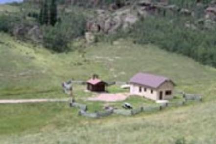
FITTON GUARD STATION CABIN, Colorado Campground Images, Info & Reservations
Listen Directions There are several ways to access the cabin from the upper and lower trailheads of the Burro Creek OHV Trail. From the west side of the town of Del Norte, head south on County Road 14 for 12 miles to the lower Burro Creek Trailhead. The cabin is 6 miles upstream from this trailhead and 1.5 miles from the upper trailhead. The upper trailhead is located 28 miles from the town of Del Norte and is accessed by Forest Service Roads 329 and 329.1C. Phone 719-657-3321 Activities BIKING, CAMPING, HIKING, HORSEBACK RIDING, HUNTING, WINTER SPORTS, WILDLIFE VIEWING Keywords FITTON GUARD STATION CABIN,FITTON GUARD,FITTON GUARD STATION Related Link(s) Rec Area Info & Images Colorado State Tourism Colorado State Road Conditions Overview Fitton Guard Station is a small cabin located in a high elevation meadow at 10,600 feet on Burro Creek near an off-highway vehicle trail. The barn was renovated
STONE CELLAR GUARD STATION, Colorado Campground Images, Info & Reservations
Listen Directions From Saguache, take Colorado Hwy 114, 34 miles northwest from Saguache, over North Pass. Take FR#804 south 4 miles to junction, east 1 mile to FR #787, then 21 miles south to the cabin. Phone 719-655-2547 Activities CAMPING, INTERPRETIVE PROGRAMS, FISHING, HIKING, HORSEBACK RIDING, HUNTING, WINTER SPORTS, WILDLIFE VIEWING Keywords Saguache Park Cabin,Stone Cellar CG,RIO GRANDE NF,SCGS Related Link(s) Rec Area Info & Images Colorado State Road Conditions Colorado State Tourism Overview Stone Cellar Guard Station is a remote cabin located at an elevation of 9,500 feet, just outside the boundary of La Garita Wilderness in Saguache Park in the Rio Grande National Forest. The cabin is a secluded getaway for guests seeking relaxation and recreation in south-central Colorado. Recreation The area offers many opportunities for hiking in summer, hunting in the fall and cross country skiing and snowmobiling in the winter. The cabin is located in a
JACKSON GUARD STATION, Colorado Campground Images, Info & Reservations
Listen Directions From Montrose, take Highway 50 east for about 20 miles. Turn right (south) onto County Road 858, which leads up the Big Cimarron Drainage for about 20 miles. Shortly after passing Silver Jack Reservoir on the right, Jackson Guard Station will be on the left. From Gunnison, take Highway 50 west for roughly 43 miles. Turn left on County Road 858, which leads up the Big Cimarron Drainage for about 20 miles. Shortly after passing Silver Jack Reservoir on the right, Jackson Guard Station will be on the left. In winter, park in parking lot before the Forest Boundary and ski, snowshoe or snowmobile up the road for 3.5 miles. Phone (970) 240-5300 Activities FISHING, HIKING, HUNTING, WILDLIFE VIEWING, PHOTOGRAPHY, OFF ROAD VEHICLE TRAILS, PADDLE BOATING, KAYAKING, CANOEING, STAR GAZING, NON-MOTORIZED BOATING, SNOWSHOEING Keywords Jackson Guard Station,Jackson Cabin Related Link(s) Rec Area Info & Images Colorado State Tourism
STUB CREEK CABIN, Colorado Campground Images, Info & Reservations
Listen Directions From Fort Collins, get off I-25 at the Mulberry Street/Highway 14 exit. Travel west on Mulberry to Riverside Ave, then north on College Avenue to Highway 287. Turn left and go west on Highway 14 (Poudre Canyon) for about 60 miles, to County Road 103. Go north on County Road 103/Laramie River Road for 16 miles, to County Road 99 (may say County Road 90 or 190 on some maps). Turn left and continue two miles to the gate. .From Steamboat Springs, travel east on Highway 14 for 87 miles, through Walden and Cameron Pass, to County Road 103/Laramie River Road. Turn left (west) and follow County Road 103 for 16 miles. Take the left fork at the junction with County Road 99 (may say County Road 90 or 190 on some maps) and continue two miles to the gate on left (west) side of road. .Maps are
LAKE ISABEL CABIN, Colorado Campground Images, Info & Reservations
Listen Directions From Pueblo, Colorado, take I-25 south to exit #74. Then head west on Highway 165 for about 20 miles. Cabin is directly across from the entrance to Lake Isabel Recreation Area. Phone FOR RESERVATIONS CALL (877) 444-6777, FOR OTHER INFORMATION CALL (719) 489-3370 OR (719) 269-8500. Activities BIKING, BOATING, CAMPING, FISHING, HIKING, HUNTING, WATER SPORTS, WILDLIFE VIEWING Keywords LISA,PIKE AND SAN ISABEL NF- FS Related Link(s) Rec Area Info & Images Colorado State Tourism Colorado State Road Conditions Overview Lake Isabel Cabin is ideal for guests who wish to experience camping in the Pike and San Isabel National Forest, yet sleep in a bed with a roof overhead. The modern cabin is full-service and can accommodate up to six guests, with convenient access to Lake Isabel, just three minutes away. Lake Isabel is one of the few lakes in Colorado developed purely for recreation. Built by the Civilian
BASSAM GUARD STATION, Colorado Campground Images, Info & Reservations
Listen Directions From Salida travel north on Highway 285 to the junction with Highways 24/285 near Johnson’s Village. Turn right onto Hwys 24/285, passing through Johnson’s Village. Stay on this highway for 5 miles, then watch for a sign on the left for County Road 307 (next to private property with railroad items on display). Turn right onto CR 307 and travel for 1.5 miles to the junction with CR 187. Turn right onto CR 187 and travel south for 7 miles to the intersection with CR 186. Turn left on CR 186 and travel southeast for .10 miles. Watch for a two-track road on the left(186 A). This road will take you to the gated entrance to the cabin. Roads may be slippery and muddy after rain or snow, drive with caution. Phone (719) 539-3591 (INFORMATION ONLY) CALL 1(877) 444-6777 FOR RESERVATIONS Activities BIKING, BOATING, CAMPING, FISHING, HORSEBACK RIDING, HUNTING
PINEY GUARD STATION, Colorado Campground Images, Info & Reservations
Listen Directions Take I-70 east from Grand Junction, CO, about 126 miles or heading west from Denver about 119 miles to exit 157. Take Highway 131 north through the town of Wolcott about 5 miles. Turn right onto Forest Road #700 (Muddy Pass Road). From this location, you must follow seasonal access directions to the cabin, as detailed below: Summer season During the summer season (early June until mid-November), it is recommended to use a high-clearance 4-wheel drive vehicle. If you choose to use a 2 -wheel drive vehicle or SUV, your must park at the intersection with Forest Road #700 and #744, which is 3 miles away from the cabin. From this location, one must hike or mountain bike to the cabin with gear and supplies. Off Highway Vehicle (OHV/ATV) may be permitted to access the cabin via Forest Roads #700 and #744; call the Ranger District ahead of
ELWOOD CABIN, Colorado Campground Images, Info & Reservations
Listen Directions From Del Norte, take U.S. Highway 160 west to South Fork. Continue west on U.S. Highway 160 for 8 miles to Park Creek Road. Travel 15 miles on Park Creek Road to Summitville Road. Turn right on FSR 380, the cabin is about 2 miles on the left. From the junction of FSR 250 in the Alamosa Canyon and FSR 380, follow FSR 380 about 8 miles, the cabin is on the right. Access to the cabin in the summertime can be accomplished with just about any vehicle; however, when the dirt roads are wet they tend to get slick. In winter, the trail access to the Elwood Cabin is on the unplowed portion of Forest Road 380, which starts southeast from the junction, but makes a bend and continues south-southwest to the cabin. The 2 mile ski to the cabin is generally easy with a 400 foot
CARNERO GUARD STATION, Colorado Campground Images, Info & Reservations
Listen Directions Carnero Guard Station may be reached by traveling south on Highway 285 approximately 15 miles south of Saguache to the La Garita turnoff (Road G). In La Garita proceed west on County Road 41G for approximately 17 miles. Look for the cabin on the right. NOTE: Forest Road 41G leading to the cabin is unimproved but may be traveled by passenger car, weather permitting. The cabin may also be accessed from Highway 114 west of Saguache, also on Forest Road 41G. During winter months, the cabin may be accessible only by snowmobile, skis or snowshoes. Phone 719-655-2547 Activities BIKING, CAMPING, FISHING, HIKING, HUNTING, WINTER SPORTS, WILDLIFE VIEWING Keywords CARN,CARNERO CABIN,RIO GRANDE NF- FS,CGS Related Link(s) Rec Area Info & Images Colorado State Road Conditions Colorado State Tourism Overview Carnero Guard Station is situated in a high open meadow surrounded by forest at an elevation of 9,840 feet. The
UPPER CROSSING GUARD STATION, Colorado Campground Images, Info & Reservations
Listen Directions Access to the cabin is only allowed via the route described in this section. The road that leads to the south of the Guard Station gate crosses private property and is not open for public access to Highway 114. From Saguache, take Highway 114 west for approximately 22 miles. The turnoff for the Guard Station is 1 mile past County Road NN14. From Gunnison, remain on Highway 114 until approximately 4 miles past the Buffalo Pass Campground entrance. The exit to the station is between mile marker 39 and 40. Look for the Upper Crossing sign on the highway. Turn east for a short distance until the road ends in a "T" Turn right and go .5 mile. The cabin will be on the left. During the winter guests may need to snowmobile, snow shoe or ski .5 miles from the nearest maintained road in order to access
SILESCA CABIN, Colorado Campground Images, Info & Reservations
Listen Directions Follow Highway 90 southwest from Montrose. Watch for signs as the highway makes several turns as it weaves its way out of town. The pavement ends where the road begins to climb out of the Uncompahgre River Valley and enters lands administered by the Bureau of Land Management. In 20 miles, it enters the Uncompahgre National Forest. Silesca Cabin is about a half-mile further on the left side of the road. Phone (970) 240-5300 Activities CAMPING, HIKING, HORSEBACK RIDING, HUNTING, WILDLIFE VIEWING, MOUNTAIN BIKING, OFF ROAD VEHICLE TRAILS, STAR GAZING, OFF HIGHWAY VEHICLE TRAILS Keywords Silesca Cabin,Silesca Historic Ranger Station,Silesca Guard Station,SILESCA CABIN (CO) Related Link(s) Rec Area Info & Images Colorado State Tourism Colorado State Road Conditions Overview The historic Silesca Cabin, once used as a Ranger Station, is a semi-rustic dwelling with comfortable modern conveniences like electricity and refrigerator. Located 40 minutes west of the city
OAK CABIN, Colorado Campground Images, Info & Reservations
Listen Directions From Grand Junction, head south on Highway 50. Take a right on County Road 141 heading south for 14.5 miles. Make a sharp left on Divide Road. This road is not marked, but prior to turn, a sign reads "National Forest Access Divide Road, Uncompahgre Plateau." Follow this road for 19.6 miles and take a left on Forest Road 406 (where a sign says "Cold Springs Work Center"). Go a quarter-mile and then turn right on 406.1A. Cabin is a half-mile after turn on the left. Have combination lock handy to enter the gate. Parking is in front of the cabin. Phone 970-242-8211 Activities BIKING, CAMPING, FISHING, HIKING, HUNTING, WILDLIFE VIEWING Keywords Cabin C at Cold Springs Ranger Station,Back Cabin at Cold Springs Ranger Station,Uncompahgre National forest,Grand Valley Ranger District,OAK CABIN (CO),Oak Cabin Related Link(s) Rec Area Info & Images Colorado State Tourism Colorado State Road Conditions Overview
DAWSON CABIN, Colorado Campground Images, Info & Reservations
Listen Directions From Buena Vista, Colorado, go about 15 miles north on Highway 24 towards Leadville. Turn left on County Road 390 at Clear Creek Reservoir. Go about 6 miles west on County Road 390, then turn right (north) onto the cabin driveway. The cabin is about 100 yards from the County Road. From Leadville, Colorado, go about 18 miles south on Highway 24 towards Buena Vista. Turn right on County Road 390 toward Clear Creek Reservoir. Go about 6 miles west on County Rpad 390, then turn right (north) onto the cabin driveway. The cabin is about 100 yards from the road. Phone 719-486-0749 (INFORMATION ONLY, NO RESERVATIONS) Activities HISTORIC & CULTURAL SITE, CAMPING, FISHING, HIKING, WILDERNESS Keywords DAWSON CABIN (CO) Related Link(s) Rec Area Info & Images Colorado State Road Conditions Colorado State Tourism Overview Dawson Cabin provides campers with a rustic, remote getaway in the beautiful Clear
PLATORO CABIN 1, Colorado Campground Images, Info & Reservations
Listen Directions From Antonito, CO, follow Highway 17 west to its junction with FSR 250. Follow FSR 250 northwest up the Conejos Canyon about 22 miles to Platoro. Turn left on FSR 250.6A and follow it 0.2 mile to the cabin. From the town of South Fork, follow Highway 160 to the southwest for about 7.5 miles. Turn left onto Park Creek Road, which is also Forest Service Road 380. Continue for approximately 27 miles, paralleling Park Creek for much of the way. Turn right (south), crossing the Alamosa River, and follow National Forest Road 250 over Stunner pass and into the town of Platoro. This stretch of the trip is about 6 miles long. The cabins are located on the southeast part of town. It is best to cross the Conejos River using the lower bridge; this is National Forest Road 250.6A. Continue on this road for about .2
Mountain cabin rentals are a form of glamping. This is a relatively new term that combines the words glamorous and camping. It is for folks that want the outdoor experience that comes with camping, but with more comfort. Learn about other forms of glamping here.