
For an unforgettable outdoor experience, check out these 36 rustic cabins in Idaho.
These scenic & secluded rustic cabins were built and are maintained by the US Forest Service.
Be sure to read the full details on each cabin, before you proceed to rent the cabins online.
Access and amenities vary widely.
Enjoy your time in scenic Idaho!
AL TAYLOR CABIN, Idaho Campground Images, Info & Reservations
Listen Directions The cabin can be accessed by traveling west from Kilgore, Idaho, via Forest Road 006 approximately 8 miles to Forest Road 478. Travel Forest Road 478 to the Steel Creek Group Area. The cabin is located just outside of the group area and can be reached by driving through the group area to the cabin. The cabin can also be reached from I-15 at Stoddard Creek Exit. Exit at the Stoddard Creek Exit and travel east on Forest Road 006 approximately 13 miles to Forest Road 478. Phone 208-374-5422 Activities CAMPING, FISHING, HIKING, HUNTING, WILDLIFE VIEWING, PHOTOGRAPHY, STAR GAZING, BIRDING, OFF HIGHWAY VEHICLE TRAILS Keywords AL TAYLOR CABIN Related Link(s) Rec Area Info & Images Idaho State Tourism Idaho State Road Conditions Overview Al Taylor Cabin is located adjacent to Steel Creek near the Continental Divide, at an elevation of 6,300 feet. Visitors come to this area for
AVERY CREEK CABIN, Idaho Campground Images, Info & Reservations
Listen Directions From I-90, take Exit 43 (Kingston); travel 23 miles north on Forest Highway 9, then continue straight for 3 miles on Forest Road 208 (2-lane paved highway) to Avery Cabin. The cabin is approximately 200 feet past milepost 26. Avery Picnic Area is directly across Forest Road 208. From Coeur d’Alene, travel time is about 1 hour. Phone 208-664-2318 Activities BIKING, BOATING, CAMPING, FISHING, HIKING, WATER SPORTS, SWIMMING SITE Keywords Avery Cabin,Avery Guard Station,Avery Creek Guard Station Related Link(s) Rec Area Info & Images Idaho State Road Conditions Idaho State Tourism Overview Avery Creek Cabin is located 20 miles northeast of Kingston, Idaho, along Forest Road 208. The fully furnished three-room cabin is adjacent to the North Fork Coeur d’Alene River on the Coeur d’Alene River Ranger District in the Idaho Panhandle National Forests. The cabin was built between 1926 and 1928 to house Forest Service employees needed
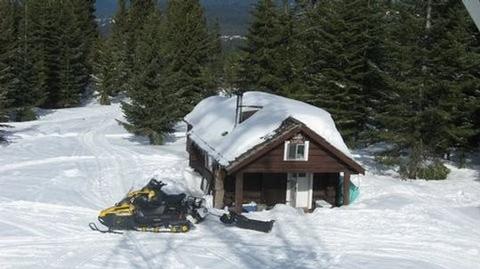
BEAVER CREEK CABIN (ID), Idaho Campground Images, Info & Reservations
Listen Directions In summer: from Idaho City, travel 20 miles northeast on State Highway 21. Turn right on Forest Road #362 and travel 1/2 mile to the cabin. In winter: from Idaho City, travel approximately 18 miles northeast on State Highway 21 to the Whoop-Um-Up Parking Area. Ski or snowshoe 1.5 miles to the cabin on the Pilgrim Trail. Phone 208-392-6681 Activities BIKING, CAMPING, FISHING, HIKING, HUNTING, WINTER SPORTS, WILDLIFE VIEWING Keywords BEAC,Beaver Creek Cabin,BOISE NF – FS Related Link(s) Rec Area Info & Images Idaho State Tourism Idaho State Road Conditions Overview The Beaver Creek Cabin site was established for administrative use in 1912. The current dwelling was built in the 1930s by the Civilian Conservation Corps using standard blueprints for that time. Beaver Creek Cabin is open year-round. It’s accessible by car in the summer months and by snowshoes or cross-country skis in winter. Guests arriving in winter
BIG TRINITY CABIN, Idaho Campground Images, Info & Reservations
Listen Directions Travel east from Boise, Idaho on I-84 to Mountain Home. At I-84/Highway 20 junction, take Highway 20 east for 35 miles to Pine/Featherville turnoff. Travel north on Forest Highway 61 for 29 miles to Forest Road 172. Travel 15 miles northwest to Forest Road 129. Travel 3 miles to the Guard Station junction. The roadway is paved up to the junction of Forest Road 172. Forest Road 172 is native material (dirt) and trailer traffic is not recommended. There are signs noting each of the junctions. Phone 208-587-7961 Activities BIKING, CAMPING, FISHING, HIKING, WILDLIFE VIEWING, CANOEING, NON-MOTORIZED BOATING Keywords BTRC,TRINITY CABIN,TRINITY GUARD STATION,BOISE NF – FS Related Link(s) Rec Area Info & Images Idaho State Road Conditions Idaho State Tourism Overview Big Trinity Cabin offers a quiet retreat in a beautiful high alpine landscape. The cabin is situated within a popular summer recreation area with many activities to
BISHOP MOUNTAIN CABIN, Idaho Campground Images, Info & Reservations
Listen Directions From Ashton, ID, travel north on Highway 20 for 16 miles, then turn left (west) on North Antelope Flat Road (#168). Travel 7.5 miles to Bishop Mountain Road (#120) and then turn right (north) and travel for about 5.4 miles. The road dead ends at the cabin. Phone 208-652-7442 Activities CAMPING, HIKING, HUNTING, WILDLIFE VIEWING, MOUNTAIN BIKING, BERRY PICKING, STAR GAZING Keywords BIMC,BISHOP MOUNTAIN LOOKOUT,CARIBOU-TARGHEE NF – FS Related Link(s) Rec Area Info & Images Idaho State Road Conditions Idaho State Tourism Overview Bishop Mountain Cabin was built by the Civilian Conservation Corps in 1938. The one-room cabin formerly housed Forest Service and Bureau of Land Management employees who stayed there to watch for forest fires. A historic fire lookout tower is nearby. The cabin was used for lookout workers until the early 1980s. Guests can drive to the cabin from mid-May through mid-November, although about 13 miles
BOILING SPRINGS CABIN, Idaho Campground Images, Info & Reservations
Listen Directions In summer: from Crouch, take Middle Fork Road/Forest Road 698 north 24 miles to the cabin. In winter, all access is over snow. From Crouch, take Middle Fork Road (Forest Road 698) north 13 miles to the snowmobile parking lot at the end of the plowed road on FR 698, just north of Tie Creek Campground. Distance to the cabin from the trailhead is 11 miles. Phone 541-351-1182 Activities BIKING, BOATING, CAMPING, FISHING, HUNTING, WINTER SPORTS, SWIMMING SITE Keywords BOIL,BOISE NF – FS Related Link(s) Rec Area Info & Images Forest Service Concessionaire Forest Service Concessionaire Idaho State Road Conditions Idaho State Tourism Overview Boiling Springs Cabin is a popular destination for those who enjoy soaking in mineral hot springs that are adjacent to the cabin. Other hot springs are within the vicinity as well. Guests who stay here also have a variety of other recreational activities to
BUCK PARK CABIN, Idaho Campground Images, Info & Reservations
Listen Directions From Council, drive 12 miles northwest on the paved Council-Cuprum Road 002, then 12 miles southwest on the gravel Buck Park Road 055 (high-clearance vehicles are necessary for passage). Continue 0.2 miles south on Buck Park Spur. Expect large rocks and a narrow, one-way road. Buck Park is a 1.5-hour drive from Council, Idaho. Phone 208-549-4200 Activities CAMPING, HIKING, HORSEBACK RIDING, HUNTING Keywords BUPC,CUDDY,CUDDY CABINS,PAYETTE NF – FS Related Link(s) Rec Area Info & Images Idaho State Tourism Idaho State Road Conditions Overview Buck Park Cabin is located on Cuddy Mountain, in the Payette National Forest of central Idaho. Guests enjoy the remote area for its hunting opportunities and abundance of hiking, biking, horseback riding and off-road vehicle trails. Recreation The cabin sits near small Rush Lake, which offers fishing opportunities. Hornet and Lower Hornet lakes are a short distance away. Hikers, mountain bikers, horseback riders and off-road
CARIBOU MOUNTAIN GUARD STATION, Idaho Campground Images, Info & Reservations
Listen Directions From Soda Springs, take Highway 34 north approximately 33 miles. Turn left on to Greys Lake Road. Drive north about 11.5 miles on Greys Lake Road and turn right onto McCoy Creek Road (Forest Road 087). Follow McCoy Creek Road (Forest Road 087) for 6.5 miles to the guard station. Maps are available upon request at the district office. Phone 208-847-0375 Activities BIKING, CAMPING, FISHING, HIKING, HUNTING, WINTER SPORTS Keywords CARI,CARIBOU-TARGHEE NF – FS Related Link(s) Rec Area Info & Images Idaho State Tourism Idaho State Road Conditions Overview Caribou Mountain and the National Forest are named after a man known as "Cariboo Jack," who discovered gold in this area in 1870. He was an adventurous man who became a local legend. Today, the guard station on Caribou Mountain is a haven for adventurers who enjoy a variety of recreational activities. The guard station can be accessed by
CLEAR CREEK GUARD STATION, Idaho Campground Images, Info & Reservations
Listen Directions From Montpelier, take Highway 89 east for 7 miles. At the Montpelier Reservoir (Crow Creek Road)/ Forest Road 111, turn north and travel 13 miles to the guard station. Maps are available upon request at the district office. From Afton, Wyoming, take Highway 89 south and turn right on WY 236 North. Drive for 2.6 miles and continue on to County Road 142/Fairview North Road. In less than a mile, turn left onto County Road 141/Crow Creek Road. Follow this road for 16.5 miles. The guard station is just off this road to the right. Phone 208-847-0375 Activities BIKING, CAMPING, FISHING, HIKING, HUNTING, WINTER SPORTS Keywords CLEC,CARIBOU-TARGHEE NF – FS Related Link(s) Rec Area Info & Images Idaho State Road Conditions Idaho State Tourism Overview Clear Creek Guard Station is located 20 miles northeast of Montpelier, Idaho. Not much is known about the history of this guard station
COLD SPRINGS PEAK CABIN, Idaho Campground Images, Info & Reservations
Listen Directions From Missoula, Montana, drive to Greer, Idaho. Follow State Highway 11 to Weippe. Continue on toward Pierce. Turn right onto French Mountain Road 250. Follow Road 250 (paved for 17 miles, gravel thereafter) to the Bungalow Bridge, which spans the North Fork Clearwater River. Turn right and remain on Road 250. Continue to the junction with Mush Saddle Road 711, about 16 miles; turn left onto Road 711. ORV riders can drive further on 2 miles to the junction with Cool Creek Road 5295 and turn right. This is a single-lane, dirt-surface road rarely graded or cleared and is slippery when wet. Watch for falling rocks. Climb steeply to the junction with Road 5295A. Make a sharp turn right. Two miles later, park and follow Flat Mountain Trail 176 for 2 miles to the cabin. About 1 mile in, Elizabeth MountainTrail 445 forks to the right. Stay left.
COPPER BASIN GUARD STATION, Idaho Campground Images, Info & Reservations
Listen Directions From Mackay, Idaho, drive north on Highway 93 approximately 17 miles and take a left on the Trail Creek Road. Travel approximately 15 miles on the Trail Creek Road. This road starts as paved and turns to gravel at approximately 12 miles. Turn left at the Wild horse/Copper Basin turnoff, and continue on this road for approximately 2 miles and bear left on Road #135. This road continues for approximately 14 miles. The Copper Basin Guard Station is on the right at the intersection of Roads 135 and 138. From Ketchum, Idaho, travel north east on the Trail Creek Road, #208, for approximately 23 miles. Turn right on at the Wildhorse/Copper Basin turnoff and continue on this road for approximately 2 miles. Bear left on Road #135. This road continues for approximately 14 miles. The Copper Basin Guard Station is on the right at the intersection of Roads
CUB RIVER GUARD STATION, Idaho Campground Images, Info & Reservations
Listen Directions From Preston, Idaho, head approximately 3 miles south on U.S. Highway 91. Turn east on Cub River Road/Forest Road 406. Proceed about 10 miles to the guard station. This road is heavily traveled throughout the summer with other recreationists, so please travel slowly and use caution. Phone 208-847-0375 Activities HISTORIC & CULTURAL SITE, CAMPING, FISHING, HORSEBACK RIDING, HUNTING, WINTER SPORTS Keywords CUBR,CARIBOU-TARGHEE NF – FS Related Link(s) Rec Area Info & Images Idaho State Tourism Idaho State Road Conditions Overview Cub River Guard Station was established in 1907, and the first cabin was built in 1909 about a mile from the current site. This cabin was short-lived, and a second structure was built in 1922 and used until 1934. A third structure occupied this area after that until it burned down in 1957. The current cabin was built 2 years later. The cabin is open year-round and can
DEADWOOD LOOKOUT REC CABIN, Idaho Campground Images, Info & Reservations
Listen Directions From Boise, Idaho, take Highway 55 north about 35 miles to Banks, Idaho. Turn right (east) on Banks-Lowman Road and proceed 25 miles to the junction with Forest Road 555. Turn left (north) on Road 555 and proceed 9 miles to the junction of Forest Roads 555 and 555EC. Turn right on 555EC and proceed 3 miles to Deadwood Lookout Recreation Cabin at the end of the road. Phone 541-351-1182 Activities BIKING, CAMPING, HIKING, WILDLIFE VIEWING Keywords DEDW,BOISE NF – FS Related Link(s) Rec Area Info & Images Forest Service Concessionaire Forest Service Concessionaire Idaho State Tourism Idaho State Road Conditions Overview Deadwood Lookout Recreation Cabin is a historic Forest Service fire lookout on Deadwood Mountain. The structure provides sweeping panoramic views of the surrounding forest, making this a unique place to overnight. At least two other lookouts have existed previously on Deadwood Mountain, but the current one
Diamond Creek Guard Station, Idaho Campground Images, Info & Reservations
Listen Directions From Soda Springs, take Highway 34 north approximately 12 miles to the China Hat turnoff (Blackfoot River Narrows). This road will follow Blackfoot River for another 11 miles to a junction; there is a Forest Service sign at this point. Take the right fork (Caribou National Forest Road 102) southeast for another 12 miles to the guard station. The road will turn into Diamond Creek Road. The guard station is about 1 mile south of the Johnson Guard Station. Maps are available upon request at the district office. Phone 208-847-0375 Activities BIKING, CAMPING, FISHING, HIKING, HORSEBACK RIDING, HUNTING, WINTER SPORTS Keywords Related Link(s) Rec Area Info & Images Idaho State Road Conditions Idaho State Tourism Overview Diamond Creek Guard Station is located 30 miles east of Soda Springs, Idaho. The current building was constructed in the early 1990â??s as a snowmobile warming hut. The cabin is accessible by
EGAN BASIN GUARD STATION, Idaho Campground Images, Info & Reservations
Listen Directions Egan Basin Guard Station is located 31 miles southwest of Montpelier, Idaho. Follow Highway 89 south 17 miles to St. Charles. Turn west on 200 North. Continue west 1.5 miles to Forest Road 411 (Green Canyon) and follow 411 west/southwest to Forest Road 415. At this intersection, follow the signs west 5 miles to the guard station sign, turn south for 1/4 mile to the guard station. Maps are available upon request at the district office. Phone 208-847-0375 Activities BIKING, CAMPING, FISHING, HIKING, HUNTING, WINTER SPORTS Keywords EGAN,CARIBOU-TARGHEE NF – FS Related Link(s) Rec Area Info & Images Idaho State Road Conditions Idaho State Tourism Overview Egan Basin Guard Station is a rustic retreat in the Montpelier Ranger District of the Caribou-Targhee National Forest of southeastern Idaho, near the Utah border. The Montpelier area is known for its abundance of year-round recreational opportunities. The guard station is accessible
EIGHT MILE GUARD STATION, Idaho Campground Images, Info & Reservations
Listen Directions Eight Mile Guard Station is located 11 miles southwest of Soda Springs. Head east on Main Street in Soda Springs. Turn right onto South 3rd Street E for 1 mile. Continue onto Bailey Creek 8 Mile Road for 3.5 miles. Turn left onto 8 Mile Road for half a mile. Continue onto Nounan Road for 1.5 miles. Turn right onto Road 425/8 Mile Canyon Road/8 Mile Creek Road. Eight Mile Guard Station will be on the right in about 3.7 miles. Maps are available upon request at the district office. Phone 208-847-0375 Activities BIKING, CAMPING, FISHING, HIKING, HUNTING, WINTER SPORTS Keywords EGTM,CARIBOU-TARGHEE NF – FS Related Link(s) Rec Area Info & Images Idaho State Road Conditions Idaho State Tourism Overview Eight Mile Guard Station is a short drive from Soda Springs, Idaho. It was established as early as 1908. Several buildings have appeared on this site, although most
JOHNSON CREEK GUARD STATION, Idaho Campground Images, Info & Reservations
Listen Directions From Cascade, ID, head north on ID-55/Main Street toward McCall, ID. Turn right/east on FH-22/Warm Lake Road. Stay on this road for about 35 miles. Turn left/north on Road 413/Johnson Creek Road. Stay on this road for about 22 miles. The cabin sits on the right/east side of the road. Look for the Forest Service sign. This is good unpaved road, but there are a few narrow and steep sections with few pull-outs, and there may be some washboard sections. Use low gears. Some sections of the road are steep. For additional information, the Cascade District Office is located in Cascade on the north end of town off Highway 55 on the right side of the road. Office hours are Monday-Friday 8 a.m. to 4:30 p.m., closed on federal holidays. Please call the office at (208) 382-7400 for information on alternate routes. Phone 208-382-7400 Activities BIKING, HISTORIC &
JOHNSON GUARD STATION, Idaho Campground Images, Info & Reservations
Listen Directions From Soda Springs, take Highway 34 north approximately 12 miles to the China Hat turnoff (Blackfoot River Narrows). This road will follow Blackfoot River for another 11 miles to a junction; there is a Forest Service sign at this point. Take the right fork (Caribou National Forest Road 102) southeast for another 10 miles to the guard station. The road will turn into Diamond Creek Road. Maps are available upon request at the district office. Phone 208-847-0375 Activities BIKING, CAMPING, FISHING, HIKING, HUNTING, WINTER SPORTS Keywords JOHG,CARIBOU-TARGHEE NF – FS Related Link(s) Rec Area Info & Images Idaho State Road Conditions Idaho State Tourism Overview Johnson Guard Station is located 30 miles east of Soda Springs, Idaho, on a site that was established in 1910. The current building was constructed in 1934, and is named after James J. Johnson, who served as ranger of the Georgetown Ranger District
KELLY FORKS CABIN, Idaho Campground Images, Info & Reservations
Listen Directions The cabin is approximately 48 miles northeast of the community of Pierce, Idaho. The last 31 miles to the cabin from Pierce are narrow, have a gravel surface and may be peppered with large potholes and rocks, so travel can be slow-going. Kelly Forks Cabin is also situated about 54 miles southwest of Superior, Montana consisting mostly of gravel surface that can be rough and partially blocked. Visitors are advised to consult a map, and the forest web site in advance of making reservations as well as prior to travel, to plan their trip accordingly. From Lewiston, Idaho: Travel 45 miles west on U.S. Highway 12 to the bridge at Orofino, Idaho. Cross the bridge – don’t deviate; you will travel on Michigan Avenue and then Grangemont Road, aka State Highway 7- and continue 30 miles north to the former Jaype Mill site. Turn right and continue 6
LITTLE GUARD LOOKOUT, Idaho Campground Images, Info & Reservations
Listen Directions From I-90, take Exit #43 (Kingston) and drive 24 miles north on Forest Highway 9 to Prichard junction. From there, continue on Forest Road 208 for about 5 miles to Forest Road 602 (on the right just past Shoshone Base Camp). Drive about 9 miles to the lookout at the end of the road. Vehicles with high clearance and good tires are strongly recommended. Phone 208-783-2363 Activities HISTORIC & CULTURAL SITE, CAMPING, HIKING, HUNTING, WILDLIFE VIEWING Keywords LILO,LITTLE GUARD,IDAHO PANHANDLE NF – FS Related Link(s) Rec Area Info & Images Idaho State Road Conditions Idaho State Tourism Overview Little Guard Lookout, located about 9 miles north of Shoshone Camp, was one of the last remaining fire lookouts used in the Coeur d’Alene River area and has only just recently become inactive. The structure standing today on Little Guard Peak is the third in a series of lookout buildings
LIZ CREEK CABIN, Idaho Campground Images, Info & Reservations
Listen Directions There are no services located on the district, so travelers should have plenty of gas, food and water for their visit, including planning for possible emergency situations. The travel route to the cabin can be quite challenging even treacherous at times, as the gravel roads on the district can be quite rough and partially blocked with debris. The preferred route into the cabin is via U.S Hwy 12 to FS Road #107 (Saddle Camp) located at mile marker 139.7 approximately 25 miles west of Powell, ID on U.S Hwy 12. Follow Rd 107 north, twelve miles to Saddle Camp Junction with roads #500 & #587. Take a hard left on the #500 Rd heading west. Follow #500 Rd 4 miles to 12 mile saddle and the trail #20 TH (Weitas Creek). From 12 mile saddle to Liz Creek Cabin is a 9.5 mile moderate hike down into the
MAGEE RANGERS CABIN, Idaho Campground Images, Info & Reservations
Listen Directions Access #1: From I-90, take Exit #43 (Kingston) and drive 24 miles north on Forest Highway 9 (two lane paved highway) to the Prichard Junction. Continue on Forest Road 208 for 28 miles to the end of the pavement and the start of Forest Road 6310 (a gravel road with rocks and potholes). Travel 7 miles on road 6310 to the Magee Ranger’s Cabin. The approximate travel time from Coeur d’Alene on this route is 2 hours. Access #2: From the Ranger Station in Coeur d’Alene, drive east on County Road #268 (Fernan Lakeshore road) for 5 miles; this road enters the Cd’Alene National Forest and climbs up into the mountains on Forest Road #268. Forest Road #268 is a paved two lane road that you will follow for 7 miles to Fernan Saddle. Continue on paved road which is Forest Road #612 (paved then graveled good quality
MALAD SUMMIT GUARD STATION, Idaho Campground Images, Info & Reservations
Listen Directions From Malad, Idaho: take I-15 north 11 miles to Exit 22 (Devil Creek Reservoir). Go north on old Highway 191 for 3.2 miles (paved road). Turn west and cross over the interstate on Forest Service Road #041 and go about two miles (good graveled road), then turn left and go a few hundred feet to the guard station. Phone 208-236-7500 Activities BIKING, CAMPING, FISHING, HIKING, HORSEBACK RIDING, HUNTING Keywords MSGS,CARIBOU-TARGHEE NF – FS Related Link(s) Rec Area Info & Images Idaho State Tourism Idaho State Road Conditions Overview Malad Summit Guard Station is located 14 miles north of Malad, Idaho on Malad Pass just off I-15. The rustic one-room cabin is in a forested setting in narrow Mill Creek Drainage, and offers a secluded retreat on fenced acreage surrounded by scenic high country views. The original guard station was established in 1908, but was replaced by the existing
PADDY FLAT GUARD STATION, Idaho Campground Images, Info & Reservations
Listen Directions If you are approaching the cabin from the north (McCall), drive approximately 9 miles south on State Highway 55. Paddy Flat Road will be a left turn (east). This is Forest Road #388. Follow road #388 approximately 5 miles to Paddy Flat Summit. At the summit take Forest Road #389, which is a slight turn to the right. Follow Forest Road #389 approximately 3 miles to the Paddy Flat Guard Station. If you are driving from the south, Paddy Flat Road will be a right turn approximately 3 miles north of the town of Donnelly. Again, this will be Forest Road #388 heading east. Follow #388 to Paddy Flat Summit, veer right onto Forest Road #389 and continue on to the guard station. Phone 208-634-0400 Activities CAMPING Keywords PADDY FLAT GUARD STATION,PADDY FLAT Related Link(s) Rec Area Info & Images Idaho State Tourism Idaho State Road Conditions Overview
PEBBLE GUARD STATION, Idaho Campground Images, Info & Reservations
Listen Directions Pebble Guard Station is located about 16 miles north of Lava Hot Springs, Idaho. Just east of Lava Hot Springs, look for the "Pebble Area" sign and turn left (north) onto Blaser Highway/Old Highway 30. Go north on the paved highway for 9 miles to Pebble Creek Road (known locally as Mike’s Place or Whiskey Mike’s). Turn left (west), across railroad tracks on gravel Forest Road 036. Travel 6.5 miles to the guard station. Big Springs Campground is 1/2-mile beyond the cabin. Phone 208-236-7500 Activities BIKING, CAMPING, HIKING, HORSEBACK RIDING, HUNTING, WINTER SPORTS Keywords PBGS,CARIBOU-TARGHEE NF – FS Related Link(s) Rec Area Info & Images Idaho State Tourism Idaho State Road Conditions Overview Pebble Guard Station is located at the base of Bonneville Peak along beautiful Pebble Creek, a tributary of the Portneuf River. The rustic one-room cabin offers a secluded retreat on four fenced acres, surrounded by
RED IVES CABIN, Idaho Campground Images, Info & Reservations
Listen Directions From St. Maries, Idaho: Follow paved Forest Highway 50 (St. Joe River Rd) 47 miles to Avery. Continue 29 more miles along FH-50 to the Red Ives Road #218. Turn right (south) on road #218 and travel 10 miles upstream to the Red Ives Ranger Station. The Red Ives Road is a narrow One-lane road with turn-outs. Phone (208) 245-2531 Activities BIKING, CAMPING, FISHING, HIKING Keywords Related Link(s) Rec Area Info & Images Idaho State Road Conditions Idaho State Tourism Overview Red Ives Cabin is a popular location in the Idaho Panhandle National Forests. It served as the Ranger Station for the Red Ives Ranger District of the St. Joe National Forest from the 1930s to 1984. Attractions include its location on the St. Joe Wild and Scenic River. It is located 86 miles southeast of St. Maries, Idaho on Forest Road 218. The Cabin requires an entry
REDFISH CABIN, Idaho Campground Images, Info & Reservations
Listen Directions Renters should check winter road reports online at 511.idaho.gov or by calling 511 or 1-888-432-7623 prior to travel. October 15, November 30: From Stanley: Intersection of Hwy 21 and Hwy 75, drive south on Hwy 75 4.25 miles to Redfish Lake Road (FS Road 214). The turn is near mile marker 185, approximately 5 miles south of Stanley. From Ketchum/Sun Valley: Drive north 55 miles on Hwy 75 to Redfish Lake Road. Hint: The turn is near mile marker 185. If you reach Stanley, you’ve gone about 5 miles too far north. From Hwy 75 and Redfish Lake Road (FS Road 214), drive 2 miles (southwest) along FS Road 214 to Redfish Visitor Center, park at Visitor Center, walk around Visitor Center to Redfish Amphitheater. Redfish Cabin is 30 yards south of amphitheater. December 1 – April 15: From Stanley: Intersection of Hwy 21 and Hwy 75, drive
SNYDER GUARD STATION (ID), Idaho Campground Images, Info & Reservations
Listen Directions Snyder Guard Station is located 36 road miles northeast of Bonners Ferry, ID and takes 50 minutes to drive from point to point. From the Bonners Ferry Ranger Station, drive north on US 95 for 29.5 miles to Moyie River Road. Turn right (south) onto Moyie River Road (at Good Grief Cafe) and travel south for 5.5 miles. Snyder Guard Station is on the right and is marked with a sign. Travel time is 50 minutes from the Bonners Ferry Ranger District. Phone 208-267-5561 Activities BOATING, CAMPING, WATER SPORTS, SWIMMING SITE Keywords None Related Link(s) Rec Area Info & Images Idaho State Tourism Idaho State Road Conditions Overview Snyder Guard station, located on the banks of the scenic Moyie River, has been listed on the National Register for Historic places since 1982. The complex of seven buildings includes a residence, two log cabins, a cookhouse, warehouse, corrals, a
SQUIRREL MEADOWS CABIN, Idaho Campground Images, Info & Reservations
Listen Directions From Ashton, ID, take Highway 47 a half-mile to Highway 32 and turn right (south). Travel 1 mile to Ashton-Flagg Ranch Road (#261). Turn left (east) and travel 22 miles to Road #032. Turn right (south) and go a half-mile to the cabin. Phone 208-652-7442 Activities CAMPING, HORSEBACK RIDING, HUNTING, WILDLIFE VIEWING, HORSE CAMPING, MOUNTAIN BIKING, STAR GAZING, BIRDING Keywords SQUI,CARIBOU-TARGHEE NF – FS Related Link(s) Rec Area Info & Images Idaho State Road Conditions Idaho State Tourism Overview Squirrel Meadows Cabin is located 24 miles east of Ashton, Idaho, just off the Ashton-Flagg Ranch Road. The current cabin was built in 1934, but the site has been used for administrative purposes since 1907. It’s listed on the National Register of Historic Places. Only one other cabin in Wyoming was constructed with the same building plan. The 2-room cabin is made of lodgepole pine and features a wood
STOLLE MEADOWS CABIN, Idaho Campground Images, Info & Reservations
Listen Directions From Boise, Idaho, take Highway 55 north 85 miles to Cascade. Turn east on Warm Lake Highway and go 25 miles to Stolle Meadows Road (427). Turn south and go 5 miles to cabin, which will be on your left up a small hill. Road construction on forest road 427 (Stolle Meadows Road) is set to begin August 1st, 2019. FR 427 from Warm Lake Highway to the junction of FR 474 will be closed Monday through Friday, 8am – 11:30am, and 1pm – 5pm. From 11:30 – 1pm the road will have one lane open with flaggers directing traffic. The road will be opened on weekends. Road construction will continue until shut down by winter conditions. Please plan your arrival and departue accoringly. Phone 208-382-7400 Activities BIKING, BOATING, CAMPING, FISHING, HIKING, HUNTING, WINTER SPORTS, SWIMMING SITE Keywords STOL,STOLLE,STOLLE CABIN,STOLLE GUARD CABIN,STOLLE GUARD STATION,STOLLE MEADOWS GUARD STATION,STOLLE MEADOWS,STOLLE
STUMP CREEK GUARD STATION, Idaho Campground Images, Info & Reservations
Listen Directions From Afton, Wyoming, travel 4 miles north on Highway 89 to the town of Grover. At Grover, turn west and travel 3 miles to Auburn. Then go south 1/2 mile to Road 110, then west 4 miles to Road 109 for 2 miles. This will put you at the guard station. Maps are available upon request at the district office. Phone 208-847-0375 Activities BIKING, HISTORIC & CULTURAL SITE, CAMPING, FISHING, HIKING, HUNTING, WINTER SPORTS, WILDLIFE VIEWING Keywords STUC,CARIBOU-TARGHEE NF – FS Related Link(s) Rec Area Info & Images Idaho State Road Conditions Idaho State Tourism Overview Stump Creek Guard Station is located along what was once the Lander Cutoff for the Oregon Trail. Visitors can trace the path that covered wagons traveled on over 150 years ago on their way to the Pacific Northwest. Wagon ruts are still carved into the soil. The guard station is accessible by
THIRD FORK CABIN, Idaho Campground Images, Info & Reservations
Listen Directions From Boise, Idaho, take Highway 55 north to Horseshoe Bend. Turn left on Highway 52 and drive west 9 miles to the junction at Sweet/Ola Highway (no road number), then take a slight right. Take this road north 17 miles to Ola. Make a slight left and continue north through Ola on Road 618 (Third Fork Road) to the Third Fork Cabin. This road changes from pavement to gravel a few miles north of Ola. Third Fork Cabin will be on the right-hand side of Rd. 618. Phone 541-351-1182 Activities BIKING, CAMPING, FISHING, HIKING, HUNTING, WILDLIFE VIEWING Keywords THIR,BOISE NF – FS Related Link(s) Rec Area Info & Images Forest Service Concessionaire Forest Service Concessionaire Idaho State Tourism Idaho State Road Conditions Overview Third Fork Cabin is a former guard station, first established in 1906 as Station 10 and renamed Third Fork in 1908. A cabin was built
WALDE LOOKOUT CABIN, Idaho Campground Images, Info & Reservations
Listen Directions From Kooskia, ID, take Highway 12 East to Kamiah. Turn left onto Woodland Road for half a mile, then take the second right onto Glenwood Road (Road 100). Stay on this paved road until you reach the junction with Yakus Creek Road (Road 519). Park here (be sure to park out of the way of traffic as there may be active logging operations throughout the winter). Travel by snowmobile along Road 519 about 1 mile where it turns into Road 514. Travel this road for approx. 9 miles where it intersects Road 101 at Fan Saddle. Continue on Road 101 for another 5 miles to Mystery Saddle and turn right on Road 486A. At the junction of Road 486D, stay to the right and follow Road 486A for another 2 miles to Walde Cabin. Phone 208-926-4274 Activities CAMPING, WINTER SPORTS, WILDLIFE VIEWING Keywords WDLC,Walde Lookout Tower,Walde Related Link(s)
WALKER CABIN, Idaho Campground Images, Info & Reservations
Listen Directions From State Highway 14, turn south on Crooked River Road #233 and proceed approximately 8 miles to the cabin on the right. Phone 208-842-2245 Activities BIKING, CAMPING, FISHING, HIKING, HUNTING, WILDLIFE VIEWING Keywords WALB,NEZPERCE NF – FS Related Link(s) Rec Area Info & Images Idaho State Tourism Idaho State Road Conditions Overview Walker Cabin is nestled among trees just off Crooked River Road #233, which leads into the Gospel-Hump Wilderness Area, in the Nez Perce National Forest. The cabin was originally built around 1930 as a summer home. Jerry and Helen Walker purchased the cabin in 1967, then donated it to the U.S. Forest Service in the 1980s. It is now available for public recreational use. The cabin must be reserved in advanced; there are no walk-ups. Recreation Crooked River is a popular area for many recreational opportunities, including hiking, trout fishing, hunting, snowmobiling and cross-country skiing. A
WARM RIVER CABIN, Idaho Campground Images, Info & Reservations
Listen Directions From Ashton ID, travel east-northeast on Highway 47 (also known as the Mesa Fall Scenic Byway) for approximately 15 miles to the intersection of Highway 47 and Forest Road 150. Turn right onto Forest Road 150 and travel approximately 2.5 miles to the intersection of Forest Road 150 and Forest Road 154. Turn right onto Forest Road 154 and travel approximately 1.0 mile to the intersection of Forest Road 154 and Forest Road 367. Keep left on Forest Road 154 for approximately 1.5 miles to the cabin. The cabin is located across the bridge adjacent to Warm River Springs and Warm River. Phone 208-652-7442 Activities BIKING, CAMPING, FISHING, HIKING, HORSEBACK RIDING, HUNTING, WINTER SPORTS Keywords WARC,WARM RIVER FISH HATCHERY,CARIBOU-TARGHEE NF – FS Related Link(s) Rec Area Info & Images Idaho State Tourism Idaho State Road Conditions Overview Warm River Cabin is located less than 20 miles from Ashton,
YELLOWJACKET GUARD STATION, Idaho Campground Images, Info & Reservations
Listen Directions From Salmon, Idaho, take Highway 93 south 5 miles, to a right turn at Shoup Bridge onto Forest Road 021 and travel 44.5 miles to Cobalt Work Center facility on Panther Creek Road 055. Continue 8 miles south on Panther Creek Road, where you will come to Porphury Creek turnoff to the right, heading west. Continue approximately 11 miles along Porphury Creek Road/Forest Road 112 to Yellowjacket Guard Station. Phone 208-756-5209 Activities AUTO TOURING, BIKING, CAMPING, FISHING, HIKING, HORSEBACK RIDING, HUNTING, WILDLIFE VIEWING, WILDERNESS, DIVING, MOUNTAIN BIKING, OFF ROAD VEHICLE TRAILS, RANGER STATION, BACKPACKING, OFF HIGHWAY VEHICLE TRAILS Keywords YELG,SALMON-CHALLIS NF – FS Related Link(s) Rec Area Info & Images Idaho State Tourism Idaho State Road Conditions Overview Yellowjacket Guard Station is a historic Forest Service Ranger Station and Work Center. Originally constructed in 1925 and remodeled in 1934 by the Civilian Conservation Corps, the structure is eligible
Rustic & secluded cabin rentals are a form of glamping. This is a relatively new term that combines the words glamorous and camping. It is for folks that want the outdoor experience that comes with camping, but with more comfort. Learn about other forms of glamping here.