Directions
Take I-70 east from Grand Junction, CO, about 126 miles or heading west from Denver about 119 miles to exit 157. Take Highway 131 north through the town of Wolcott about 5 miles. Turn right onto Forest Road #700 (Muddy Pass Road). From this location, you must follow seasonal access directions to the cabin, as detailed below:
Summer season
During the summer season (early June until mid-November), it is recommended to use a high-clearance 4-wheel drive vehicle. If you choose to use a 2 -wheel drive vehicle or SUV, your must park at the intersection with Forest Road #700 and #744, which is 3 miles away from the cabin. From this location, one must hike or mountain bike to the cabin with gear and supplies. Off Highway Vehicle (OHV/ATV) may be permitted to access the cabin via Forest Roads #700 and #744; call the Ranger District ahead of time.
Winter season
Accessing the cabin during the winter season (December 1 to late April) depends on snowpack. During high snowpack, park at the intersection with Forest Road #700 and Highway 131. From here, travel via snowmobile, skis, or snowshoes on Forest Road #700 for approximately 7 miles. Then, turn onto Forest Road #744 and travel 3 miles to the cabin. If the snow is minimal, you may be able to use a high clearance 4-wheel drive to the gravel pit area, which is just past the intersection with Forest Road #700 and #744 and approximately 7 miles from Highway 131. From the gravel pit area, snowmobile, ski, or snowshoe on Forest Road #744 for approximately 3 miles to the cabin.
Phone
970-827-5715
Activities
BIKING, CAMPING, HIKING, HUNTING, WINTER SPORTS, WILDLIFE VIEWING
Keywords
PIGS,PINEY CABIN,WHITE RIVER NF -FS
Related Link(s)
Colorado State Road Conditions
Overview
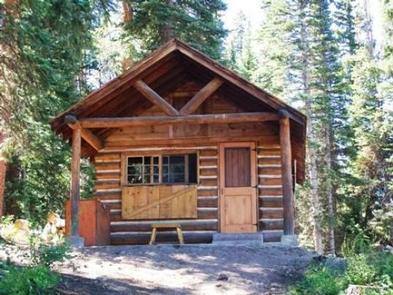
Piney Guard Station is a rustic cabin that was constructed in the 1930s as a work station for Forest Service crews. This 14 by 22-ft. structure has a single room and is built from logs. It is open both summer and winter with spring and late fall closures.
Recreation
The cabin is conveniently located in an area offering a variety of year-round recreational activities. The Forest Service road leading to the cabin is used by mountain bikers, hikers, snowshoers, cross-country skiers and snowmobilers. This area is popular for hunting big and small game, game birds and waterfowl.
Facilities
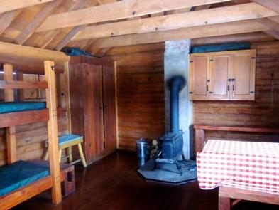
Piney Guard Station can sleep up to four people. It contains a bunk bed, two cots, storage cabinets, a table and benches, and a woodstove. Skillet, dishware and utensils are provided. A two burner stove and lantern are provided. These require 16.4-oz. propane cylinder bottles, which are not provided and are your responsibility. A picnic table and metal fire ring are just outside the cabin’s door. A vault toilet is located approximately 50 feet from the cabin. Guests can easily gather firewood around the cabin.
No drinking water, electricity or trash service is available; guests must bring their own water and garbage bags to pack out trash. Guests should consider packing most items they would bring on a regular camping trip. Dogs are allowed, please pick up after them and do not leave them unattended in or around the cabin.
Natural Features
Piney Guard Station is located at 9,100 feet in the White River National Forest, Eagle/Holy Cross Ranger District, which is near Vail. The cabin is nestled in a forest dominated by aspen, spruce, pine and fir trees. Guests can enjoy views of the Gore Mountain Range from a meadow to the cabin’s north side.
Local wildlife, including moose, may be spotted near the lake, which sits across the road from the cabin. The White River National Forest is also home to elk, bighorn sheep, mountain goats, mule deer, Canada lynx and black bear. Birders may see bald eagles, peregrine falcons, Barrow’s golden-eye and black swifts.


