HOUSTON SHELTER, AL Campground Reservation, Info, Images, Map, Directions

HOUSTON SHELTER, Alabama Campground Images, Info & Reservations

Listen

Directions

About 50 miles southwest of Decatur, take Highway 278 east from Double Springs for 8 miles. Turn south on County Road 63 and continue for 4 miles. Turn right onto Forest Service Road 118 and travel a mile to the campground.

Phone

205-489-5111

Activities

BOATING, FISHING, HIKING, WILDERNESS, DAY USE AREA, SWIMMING SITE, SWIMMING, RANGER STATION, WATER ACTIVITIES, KAYAKING, CANOEING, BIRDING, WATER ACCESS, JET SKIING, WATER SKIING

Keywords

HOUR,NFs IN ALABAMA – FS

Related Link(s)

Rec Area Info & Images

Alabama State Road Conditions

Alabama State Tourism

Overview

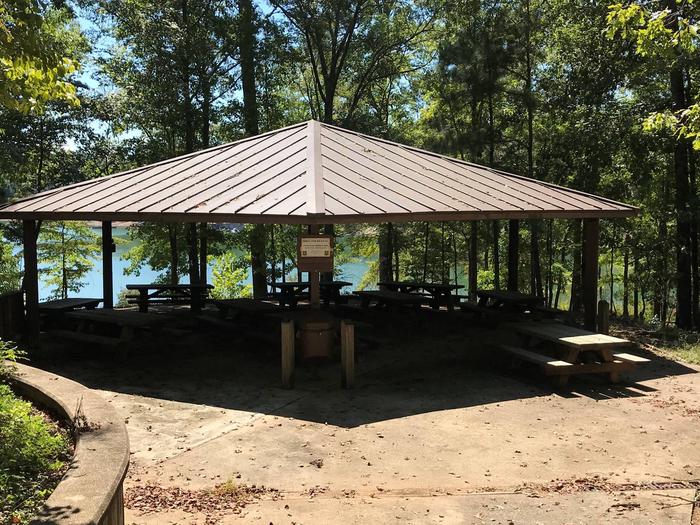
Houston Shelter is a group picnic site nestled on the shore of Lake Lewis Smith in Bankhead National Forest. This is a popular recreation area offering a variety of activities. Shelter is first come first served. Site is walk-up only.

Recreation

Day users can enjoy a beautiful sand swimming beach. Other activities include motorized and non-motorized boating and water skiing.

Anglers can fish for Kentucky Spotted Bass and Hybrid Striped Bass. There are also hiking trails in the area, including the 1.4 mile High Rock Loop and the nearly 2 mile Fox Run Loop.

Facilities

The picnic facility offers tables, flush toilets, grills and drinking water. A boat ramp and showers are nearby.

Natural Features

Bankhead National Forest is located in northwestern Alabama. The prominent feature of the area is the Sipsey Wilderness.

Known as “The Land of a Thousand Waterfalls,” the Sipsey Wilderness encompasses an area of abundant streams, old-growth forests, limestone bluffs and lush canyons.

Lake Lewis Smith boasts more than 500 miles of shoreline marked by high rock bluffs. The water is clear and deep and provides excellent fishing.

Reservation

More from CampingHiking.net:

TRILLIUM, Oregon Campground Images, Info & Reservations

Listen Directions From Portland, travel southeast on Highway 26 for about 40 miles. Turn right a mile east of Government Camp. Continue 2 miles to the campground entrance. Phone 503-630-5721 Activities HISTORIC & CULTURAL SITE, CAMPING, INTERPRETIVE PROGRAMS, FISHING, HIKING, DAY USE AREA, SWIMMING SITE Keywords TRIL,MT. HOOD NF –

WARNER LAKE, Utah Campground Images, Info & Reservations

Listen Directions From Moab, the fastest access (about 1 hour) to Warner Lake Campground is by driving south on Highway 191. Drive 6 miles south of Moab and turn east (left) onto Old Airport Road (sign has arrow to La Sal Loop Road, National Forest Access). Turn south (right) at

OWENS CREEK CAMPGROUND, Maryland Campground Images, Info & Reservations

Listen Directions For GPS Use Only: The street address is 15882 Foxville Deerfield Road, Sabillasville, MD. This is not the mailing address. The Park mailing address is: Catoctin Mountain Park, 6602 Foxville Road, Thurmont, MD 21788. From Washington DC Take the George Washington Memorial Parkway north to I495 to I270

ASPEN CABIN, Oregon Campground Images, Info & Reservations

Listen Directions From Lakeview, drive 6 miles north on Highway 395 and turn right (east) on Highway 140. Drive for 8 miles on Highway 140 and turn left on Forest Road 3615. Drive 7.5 miles on Forest Road 3615 to arrive at the cabin. The entire route to the cabin