

Directions
Family Campground- From Covington, VA, take Exit 16A off Interstate 64 to US Rt. 220. Go north on Rt. 220 for 5.6 miles to State Rt. 687. Turn left onto Rt. 687 and go 3.2 miles to State Rt. 641. Turn left onto Rt 641/666 and go 4.2 miles to State Rt. 605. Then turn right onto Rt. 605 and proceed 2 miles to campground entrance on left.
Group Campsites- From Covington, VA, take Exit 16A or 16Boff I-64. Follow signs for US 220 and travel north on US 220 for about 5.5 miles. Turn left on State Road (SR) 687, (Jackson River Road) and travel about 3.2 miles. Turn left on SR 641 (Indian Draft Road). This shortly becomes SR 666. Travel about 4.2 miles on 641/666. You will come to a three-way intersection. Turn right onto SR 605 and travel about 2.5 miles, then turn left at the sign for the US Army Corps of Engineers Visitor’s Center. Travel about 0.1 miles and there will be a heavy wooden gate on the left. Directions for entering the group area are on your confirmation letter. Open the gate and follow the signs to the group site you reserved.
Phone
540-279-4144
Activities
BOATING, CAMPING, HIKING, SWIMMING SITE
Keywords
MORR,GEORGE WASHINGTON NF,GATHRIGHT DAM,LAKE MOOMAW,SOUTH SIDE,ALLEGHANY COUNTY SIDE,JAMES RIVER DISTRICT,GEORGE WASHINGTON/JEFFERSON NF-FS,MORRIS HILL,MORRIS HILL SPUR
Related Link(s)
Virginia State Road Conditions
Overview
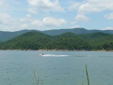
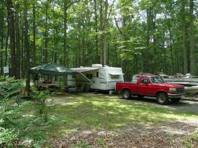
Morris Hill is a peaceful, rustic campground for groups of family and friends. The family campground is a family-friendly destination perched on a ridge above Lake Moomaw. Kids can have fun at the playground while older generations sit back and relax in the shade. The group sites accommodate up the 25 guests with space for up to eight tents. Campers can enjoy the wonders of camping with simple pleasures like s’mores on the campfire, berry picking in the woods, and watching for waterfowl and wildlife like deer. The convenient location near Lake Moomaw and sandy swim beaches, a fishing pier, boat ramp, and hiking and biking trails makes Morris Hill a popular spot.
Recreation
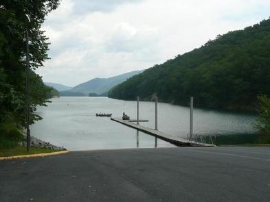
An inviting swimming beach at Coles Point attracts many visitors. About less than a mile from the campground is a fishing pier where anglers seek brown and rainbow trout, bass and crappie. Back Creek is also nice for trout fishing. Hikers enjoy the Morris Hill Bike Trail and Fortney Loop Trail.
Facilities
Family Campground: Most sites will fit any size RV. Campsite amenities include flush toilets, hot showers, a playground and drinking water. Group Sites: There is no water or electricity. Two fully accessible vault toilets, picnic tables and a group grill are on each group site. Coles Point Boat Ramp, the nearest boat ramp to Morris, is less than two miles away.
Natural Features
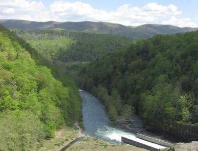
The campground sits on a ridge overlooking Lake Moomaw. It is about a half-mile from the south end of the lake. Lake Moomaw, which flows from the Jackson River, is a cold-water 2,530-acre lake with an inviting swimming beach.
Morris Hill is part of the George Washington and Jefferson National Forests which spans across Virginia and parts of West Virginia and Kentucky. These forests protect 40 species of trees that are mostly Appalachian hardwood and mixed pine-hardwood forests, 60 species of mammals and 200 species of birds.
Nearby Attractions
Head downstream of the Jackson River for fly fishing, canoeing, rafting and kayaking. A half hour east of the lake is Hot Springs, Virginia, a quaint village known as a rural resort town.