Trout Pond Recreation Area, WV Campground Reservation, Info, Images, Map, Directions

Trout Pond Recreation Area, West Virginia Campground Images, Info & Reservations

Listen

Directions

From Strasburg, VA, follow State Route 55 west for 18 miles to Wardensville, WV. Turn left on SR 23/10, and travel for about 6 miles. Turn right on CR 16, and travel for 6 miles. Turn left onto Forest Service Road 500, and drive about 1 mile to the Trout Pond Recreation Area entrance.

Phone

1(304)897-6450

Activities

CAMPING, FISHING, HIKING, SWIMMING SITE

Keywords

TROP,GEORGE WASHINGTON/JEFFERSON NF-FS,Trout Pond

Related Link(s)

Rec Area Info & Images

West Virginia State Road Conditions

West Virginia State Tourism

Overview

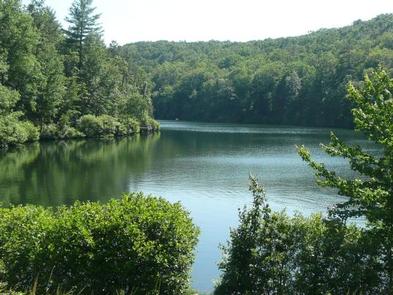
Trout Pond Recreation Area boasts two bodies of water, Rock Cliff Lake and Trout Pond. Relax on a sandy mountain beach or fish for stocked trout while relaxing along the cool waters of Rock Cliff Lake.

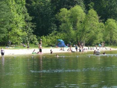
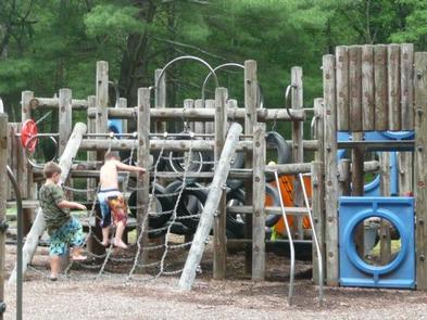
Trout Pond, home to native Brook trout, is the only natural lake in West Virginia. A designated swimming area, easy lakeside trails, and a children’s playground make this a perfect family destination.

Recreation

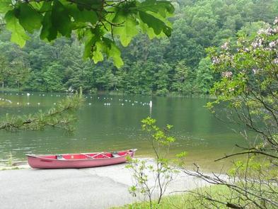
A trail surrounding the entire lake provides bank fishing access at Rock Cliff Lake. All types of boating from motor to sailboats are welcome.

Hike the Trout Pond Loop trail, an easy 4-mile excursion, with an optional 2-mile side route, to an overlook of Rockcliff Lake. For a more challenging hike, a connecting trail provides a steep climb up Long and Devil’s Hole Mountains.

Facilities

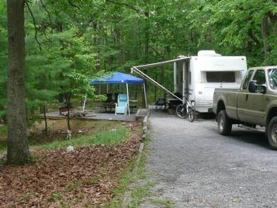
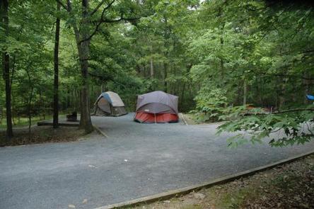
Campsites come with a campfire ring and picnic table, and some of have electric hookups. Hot showers and flush toilets are an easy walk away from each site.

The day-use area includes a white-sand swim beach, boat ramp, showers, playground and 30 picnic sites.

Natural Features

Rock Cliff Lake is a 17-acre man-made lake with a maximum depth of 36 feet and an average depth of 12 feet. Trout Pond, the naturally formed lake, was created by a sinkhole that filled with mountain stream water and run-off from Long Mountain.

Charges & Cancellations

group shelter nonelectric 1-50 people $65, 51-100 people $100, standard non electric is $19.00 per night

Reservation

More from CampingHiking.net:

OAK (Navarro Mills Lake), Texas Campground Images, Info & Reservations

Listen Directions From Waco or Corsicana, Texas, take State Highway 31 to the intersection with FM 667. Turn north on FM 667 and travel about 1.5 miles to the park entrance on the left side of the road. Phone 254-578-1431 Activities BOATING, CAMPING, FISHING, SWIMMING SITE Keywords OAK1,NAVARRO MILLS LAKE,NAVARRO

TILLIE CREEK, California Campground Images, Info & Reservations

Listen Directions From Bakersfield, California, take Highway 178 east to the town of Lake Isabella. From Lake Isabella take Highway 155 north, traveling 6 miles to the entry station of Tillie Creek Campground. Phone 760-376-1815 Activities BOATING, CAMPING Keywords TILL,LAKE ISABELLA,KERN VALLEY,SEQUOIA NF – FS Related Link(s) Rec Area Info

PLASKETT CREEK CAMPGROUND, California Campground Images, Info & Reservations

Listen Directions From San Luis Obispo, travel north on Highway 1 for approximately 65 miles to the campground. From Monterey, travel south on Highway 1 for approximately 50 miles to the campground. Phone 805-434-1996 Activities BIKING, CAMPING, FISHING, HIKING, HUNTING, WILDLIFE VIEWING Keywords Plaskett,Plaskett Creek,LOS PADRES NF -FS Related Link(s)

BREILAND SLOUGH CABIN, Alaska Campground Images, Info & Reservations

Listen Directions From Petersburg, the cabin is 15 miles by float plane or 25 miles by boat. It is accessible at any tide. Refer to USGS topographic map Petersburg C4; Petersburg C3 and D4 may also be helpful. Maps are available online or by calling the Petersburg Ranger District at

PICKETT BUTTE LOOKOUT, Oregon Campground Images, Info & Reservations

Listen Directions Important note regarding GPS use: please be advised that GPS units can, and have sent guests down the wrong roads to access the lookout. Please consider following the directions below rather than your GPS unit. Directions: From Canyonville take West 1st Street and turn onto SE 3rd St/OR-227.

LUNA WHITE DEER CAMPGROUND, Wisconsin Campground Images, Info & Reservations

Listen Directions From Eagle River, travel 13.4 miles on STH 70 to FR2176 (Divide Road). Turn right (south) and continue 5.6 miles to FR2188. Turn right and travel 0.7 miles to the campground. Phone (715) 479-2827 Activities BIKING, BOATING, CAMPING, FISHING, WILDLIFE VIEWING, SWIMMING SITE Keywords Related Link(s) Rec Area