PLAYGROUND GROUP, AZ Campground Reservation, Info, Images, Map, Directions

PLAYGROUND GROUP, Arizona Campground Images, Info & Reservations

Listen

Directions

Take State Highway 89A (seven miles southwest of Jerome or 13 miles east of Prescott Valley) to Forest Road 104. Travel on Forest Road 104 for two miles to Playground Group Campground.

Phone

928-567-4121 DURING OFFICE HOURS 0800-0430 M-F

Activities

CAMPING, PICNICKING

Keywords

PLAY,PRESCOTT NF – FS

Related Link(s)

Rec Area Info & Images

Arizona State Tourism

Arizona State Road Conditions

Overview

Close to historic western towns and centrally located in Arizona, Playground Group Campground is a great place for groups of up to 100 people to enjoy a secluded mountain getaway.

The 7,500 ft. elevation of the site, puts it near the summit of Mingus Mountain in Prescott National Forest. Spectacular views of the surrounding desert valleys as well as the nearby towns of Sedona, Jerome and Prescott Valley await campers on the winding drive to and from the site.

Recreation

The surrounding forest offers many hiking trails of various levels of intensity, from easy short-distance walks to more challenging elevated climbs.

Campers who need a break from hiking can relax around the campground, take in the views and listen to the sound of the wind in the pines.

Facilities

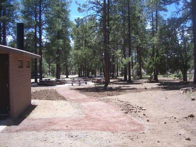
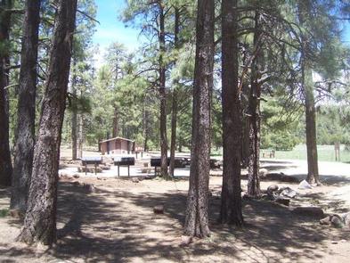
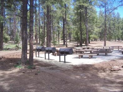
The site has a large group gathering place with picnic tables, grills, a large fire pit and vault toilet and is adjacent to a family picnic area. There is no drinking water available.

The nearby towns of Prescott Valley and Cottonwood have grocery stores, restaurants, gas stations, shopping and other conveniences.

Natural Features

The campground is in a secluded site in the tall ponderosa pine trees. Pleasant daytime temperatures and cool mountain breezes make it a nice respite from the summer heat of nearby deserts.

Nearby Attractions

A short drive away is the colorful town of Jerome, an abandoned mining town that has been transformed into an artist and tourist community.

Tuzigoot National Monument, an ancient ruin of the Sinaguan culture, and Dead Horse Ranch State Park, which has mountain biking, canoeing and fishing along the Verde River, are also close by.

Tuzigoot National Monument

Dead Horse Ranch State Park

Reservation

More from CampingHiking.net:

LAGUNA, California Campground Images, Info & Reservations

Listen Directions Located 50 miles east of San Diego, California. Take I-8 to Sunrise Highway exit. Go approximately 15 miles to Laguna/El Prado Campground, just beyond the 26 mile marker. Stop at the entrance station for campground information and site location. Phone 619-473-2082 Activities BIKING, CAMPING, HIKING, DAY USE AREA

BLACK ROCK, Idaho Campground Images, Info & Reservations

Listen Directions From Idaho City, travel north on State Highway 21 for about two miles, to the Granite Creek/Rabbit Creek Road No. 327. Turn right and travel east for 18 miles on Road No. 327, to the campground. Phone 208-392-6681 Activities BIKING, CAMPING, FISHING, HIKING, WILDLIFE VIEWING, SWIMMING SITE Keywords

WINHALL BROOK, Vermont Campground Images, Info & Reservations

Listen Directions From Brattleboro, Vermont, travel 30 miles north on Route 30. Turn north onto Route 100 and continue for 2.5 miles. Turn onto to Winhall Station Road and follow for a mile to the campground. From Manchester, Vermont, travel 5 miles east on Route 11. Turn right onto Route

CAROLINA HEMLOCKS REC AREA, North Carolina Campground Images, Info & Reservations

Listen Directions From Asheville, North Carolina, take I-26 west to exit 9, onto 19 east toward Burnsville. Follow 19 to Micaville and turn right onto Highway 80. Follow 80 south approximately 8 miles to the Carolina Hemlocks Recreation Area. Phone 828-675-5509 Activities BIKING, CLIMBING, CAMPING, INTERPRETIVE PROGRAMS, FISHING, HIKING, PICNICKING,

Money Creek Campground, Washington Campground Images, Info & Reservations

Listen Directions From Everett, Washington, take Highway 2 toward Monroe. From Monroe go east approximately 30 miles to campground sign. Turn south and travel a mile to campground. Phone 360-419-5115 Activities BIKING, CAMPING, FISHING, HIKING Keywords MONE,MT. BAKER-SNOQU NF – FS Related Link(s) Rec Area Info & Images Washington State

Trapper Creek Campground, Oregon Campground Images, Info & Reservations

Listen Directions From I-5 take exit 188A, heading west on Highway 58 for 62.4 miles, then continue 1.9 miles south on Road 5810 to the campground. Phone 541-323-1746 Activities BIKING, BOATING, CAMPING, FISHING, HIKING, WATER SPORTS, SWIMMING SITE Keywords TRPC,Trapper,Trap,Shelter Cove,Odell,Trapper Creek,Trapper Creek Campground Related Link(s) Rec Area Info &