FALLS CAMPGROUND, ID Campground Reservation, Info, Images, Map, Directions

FALLS CAMPGROUND, Idaho Campground Images, Info & Reservations

Listen

Directions

From Idaho Falls, travel 45 miles east on Highway 26. Turn off right before the Snake River Bridge and continue 3.5 miles on a gravel road to the campground.

Phone

208-270-0150 OR 541-351-1182

Activities

BIKING, BOATING, CAMPING, FISHING, HIKING, WILDLIFE VIEWING, SWIMMING SITE

Keywords

FAID,CARIBOU-TARGHEE NF – FS

Related Link(s)

Rec Area Info & Images

Forest Service Concessionaire

Idaho State Road Conditions

Idaho State Tourism

Overview

Falls Campground is located next to the Snake River in beautiful Swan Valley at an elevation of 5,100 feet.

Idaho Falls, Idaho is just 45 miles west. Visitors enjoy fishing and canoeing on the Snake and viewing local wildlife.

Recreation

The Snake River offers excellent cutthroat trout fishing, canoeing, floating, rafting and kayaking. Conant Boat Ramp is nearby and open to the public.

Facilities

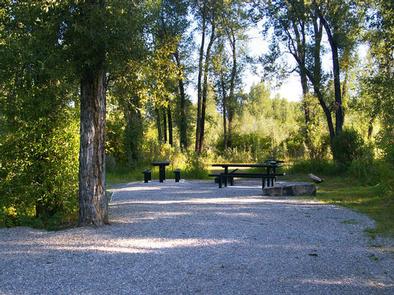
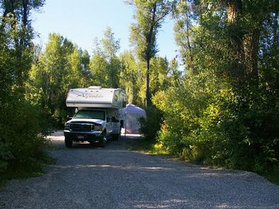
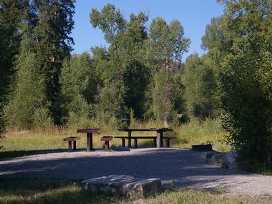
The campground offers one group site that can accommodate up to 150 people. Several single sites are also available, all with picnic tables, campfire rings and grills.

Vault toilets, drinking water and trash collection are provided, but there is no electricity. Firewood is available for purchase from the host. Roads and parking spurs are gravel.

Natural Features

The campground is situated alongside the Snake River among cottonwood trees, which provide partial shade. Grassy meadows and summer wildflowers dot the landscape. Wildlife is plentiful in the river bottom. Eagles, osprey, moose and deer are frequently spotted.

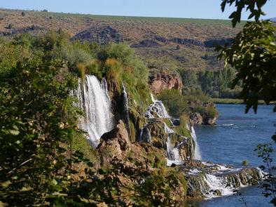
Fall Creek Falls is less than 1/4 mile from the campground. This scenic cascade drops 60 feet over a travertine outcropping on the river’s edge. It is visible from some parts of the campground.

Nearby Attractions

Palisades Reservoir is less than 20 miles from Falls Campground, with great boating, water skiing, canoeing, fishing and swimming. The Fall Creek area has many trails for hiking, mountain biking, horseback and ATV riding.

Reservation

More from CampingHiking.net:

SHELL CREEK, Wyoming Campground Images, Info & Reservations

Listen Directions Located 32 miles east of Greybull, Wyoming, on U.S. Highway 14. Turn off onto Paintrock Lakes Road (Forest Road 17). Shell Creek Campground is 1.5 miles from the turnoff. Phone 406-587-9054 Activities BIKING, CAMPING, FISHING, HIKING, HORSEBACK RIDING, WILDLIFE VIEWING Keywords SHEL,BIGHORN NF – FS Related Link(s) Rec

OLD HIGHWAY 25, Arkansas Campground Images, Info & Reservations

Listen Directions From Heber Springs, AR, take SR-25 6.25 miles north to SR-25S. Travel SR-25S 3 miles west and follow signs to campground. Phone 501-250-0483 Activities CAMPING, SWIMMING SITE Keywords OH25,GREERS FERRY LAKE,OLD 25,TUMBLING SHOALS,HEBER SPRINGS,GREERS FERRY LAKE Related Link(s) Rec Area Info & Images Arkansas State Road Conditions Arkansas

NAT CALDWELL PARK, Tennessee Campground Images, Info & Reservations

Listen Directions From Nashville, take I-65 North to TN-386/Vietnam Veterans Blvd. Continue East on TN-386/Vietnam Veterans Boulevard to exit 9. Merge onto US-31E N/Johnny Cash Pkwy/E Main St. and continue approximately 2.5 miles. Nat Caldwell Park will be on your left just before crossing over Station Camp Creek. Phone (615)

NAMEKAGON, Wisconsin Campground Images, Info & Reservations

Listen Directions From Cable, Wisconsin, take County Highway M east for 11 miles. Turn left on County Highway D and proceed about 6 miles to Forest Service Road 209. Turn left at the campground sign and drive less than a mile to the campground entrance. Phone (715) 634-4821 OR (715)

DEMOTTE, Arizona Campground Images, Info & Reservations

Listen Directions From Kanab, UT the facility is 40 miles (35 miles from Fredonia, AZ) south on U.S. Route 89A to AZ State Route 67, at Jacob Lake. Then south 25 miles on AZ State Route 67 to DeMotte campground. From Bitter Springs intersection of U.S. 89 and 89A. Take