
Directions
From Oroville, travel east on Highway 70 for about 65 miles. From Quincy, travel west on Highway 70 for 17 miles.
Phone
530-283-0555
Activities
CAMPING
Keywords
HALL,TWAIN,FEATHER RIVER CANYON,PLUMAS NF – FS
Related Link(s)
California State Road Conditions
Overview
Hallsted campground is conveniently situated in the Feather River Canyon, just off the main road in the northern Sierra Nevada Mountains. At an elevation of 2,300 feet, it offers a cool getaway from the summer heat, as well as a variety of outdoor activities
The route on the nearby Feather River National Scenic Byway traverses a steeply carved river gorge that encapsulates the historic railroad system from Oroville to Quincy and impressive powerhouses built to provide hydroelectricity.
Recreation
Fly fishing for trout and swimming are popular activities in the nearby north fork of the Feather River.
Facilities
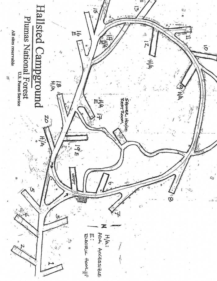
Hallsted is within walking distance of the Feather River. The campground offers multiple single-family sites, accommodating both tent and trailer camping. Tables and campfire rings with grills are provided, as well as flush toilets, showers and drinking water.
Recently renovated, most of Hallsted’s campground spurs have been widened and lengthened as well as multiple sites now have power. The shower and bathroom facilities are all new. In addition, a nice walking path meanders through the forest and takes you down to the North Fork of the Feather River.
Natural Features
Mature pine and fir trees provide ample shade for the campground, as well as a perfect atmosphere for mountain camping. Several sites parallel the north fork of the Feather River. A variety of wildlife make its home in the area.
Nearby Attractions
A general store is available in Twain, less than a half-mile from the campground. Quincy is approximately 17 miles east, providing the nearest source of fuel.