CHILATCHEE CREEK, AL Campground Reservation, Info, Images, Map, Directions

CHILATCHEE CREEK, Alabama Campground Images, Info & Reservations

Directions

From Alberta, Alabama, take State Route 5. Turn onto Wilcox County Road 29 and travel southeast for 11 miles. Make a left on Chilatchee Creek Road and continue for 2 miles to the campground.

Phone

334-573-2562

Activities

BOATING, CAMPING, FISHING, HUNTING, VISITOR CENTER, WILDLIFE VIEWING

Keywords

CHIL,GEES BEND,ALABAMA RIVERS,MILLERS FERRY LAKE,WILLIAM DANNELLY,ALABAMA RIV. – DAN

Related Link(s)

Rec Area Info & Images

Alabama State Tourism

Alabama State Road Conditions

Overview

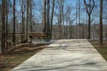
Chilatchee Creek Campground is located on its namesake at scenic Dannelly Reservoir in Alabama’s Black Prairie Belt. The reservoir sits on the Alabama River and covers roughly 27 square miles, boasting more than 500 miles of shoreline.

Boating, fishing, hunting and hiking are popular activities.

Recreation

The park offers excellent fishing for bass, crappie, bluegill and catfish, and numerous fishing tournaments and annual festivals are held in the immediate area.

Whitetail deer and wild turkeys roam the park, creating excellent bow-hunting opportunities.

Facilities

This waterfront campground contains 33 family sites with electric hookups. Amenities include flush toilets, showers, drinking water, laundry facilities and a dump station.

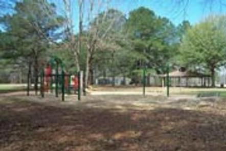
A fishing dock, boat ramp, fish cleaning stations and a playground offer additional recreation opportunities.

Natural Features

The Black Prairie Belt is characterized by rich, dark soils and a mosaic of rolling grasslands and dense hardwood and pine forests.

Reservation

More from CampingHiking.net:

MISSION LOOKOUT, Montana Campground Images, Info & Reservations

Directions From Swan Lake, travel south on Highway 83 for 3 miles. Turn west onto Porcupine Creek Road 10229 (mile-marker 68). After passing Forest Road 9714, turn right onto Forest Road 9803 (2.2 miles after leaving the state highway). Continue on Forest Road 9803 for 1.4 miles, to a gate.

CLEAR CREEK (AL), Alabama Campground Images, Info & Reservations

Directions From Jasper travel approx. 5 miles north on State Road 195 to Manchester, 8.5 miles north on County Road 27 to entrance.  From Double Springs travel approx. 12 miles south on State Road 195 to Lamon Chapel Road go to the end and turn left on County Road 27

SAVENAC COOKHOUSE, Montana Campground Images, Info & Reservations

Directions From Missoula, travel west on Interstate 90 for 90 miles, to Haugan (Exit 16). Turn right at the stop sign. At the frontage road turn right, then take the first left, crossing the cattleguard. Signs are onsite if needed. Maps are available online or for purchase by calling the

ELKHORN CAMPGROUND, Utah Campground Images, Info & Reservations

Directions From Loa, Utah, travel northeast on U-72 for 12 miles. Turn east on Forest Road 206 and travel 8 miles to the campground. The dirt road is narrow, steep and single-lane in some places. Phone 435-836-2811 Activities BIKING, CAMPING, HIKING, VISITOR CENTER Keywords ELKH,FISHLAKE NF – FS Related Link(s)

SIX MILE CREEK, Alabama Campground Images, Info & Reservations

Directions From Selma, Alabama, follow US-41 south for 9 miles. Turn right on County Road 139 and follow the signs into the campground. Phone 334-872-9554 Activities BOATING, CAMPING, FISHING, HUNTING Keywords SIXM,ALABAMA RIVERS,ROBERT F. HENRY,MILLERS FERRY LAKE,WILLIAM DANNELLY,ALABAMA RIV. – DAN Related Link(s) Rec Area Info & Images Alabama State