FOSCUE CREEK, AL Campground Reservation, Info, Images, Map, Directions

FOSCUE CREEK, Alabama Campground Images, Info & Reservations

Listen

Directions

From Demopolis, Alabama, drive three miles west on U.S. Highway 80, and turn right at Maria Street. Go approximately two miles and follow signs to the campground entrance.

Phone

334-289-5535

Activities

BOATING, CAMPING, FISHING, WATER SPORTS

Keywords

DAMF,DEMOPOLIS LAKE,FOSCUE CREEK PARK,FOSCUE PARK,BLACK WARRIOR

Related Link(s)

Rec Area Info & Images

Alabama State Tourism

Alabama State Road Conditions

Overview

Foscue Creek Campground is nestled on the forested lake shore of Demopolis Lake, the largest lake on the Black Warrior-Tombigbee Waterway.

Demopolis Lake offers 10,000 acres of water to explore. The region is excellent for hunting, and game is plentiful.

Foscue Creek Campground offers a peaceful retreat for families, anglers, boaters and those who want to get away any time of year.

Recreation

Fishing and hunting are the most popular activities in the area. Whether fishing by boat or along the bank of the park, anglers can fish for bass, crappie, bream, catfish and other species.

Day-use visitors and campers alike can enjoy a boat ramp and hiking trail at the campground. Foscue Creek Nature Trail takes walkers and joggers along the shoreline and provides benches for wildlife viewing and trail markers for tree identification.

Facilities

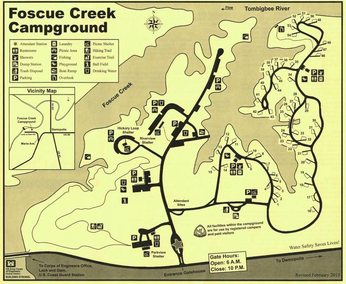
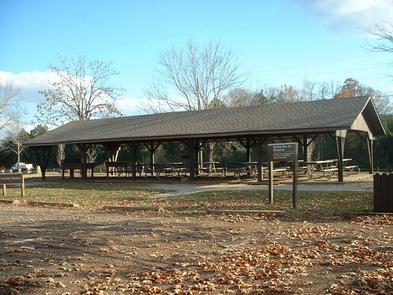
This facility has both a day-use area and a campground. There are four shelters for group picnics of between 25 to 80 people.

The 54 campsites feature picnic tables, lantern holders and campfire rings with grill. Campsites are spacious, private and located near or close to the water.

Natural Features

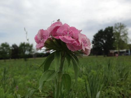
The campground lies south of the confluence of the Black Warrior and Tombigbee Rivers. The Black Belt region of Alabama is a diverse area of dense conifer stands and rolling meadows that feature colorful wildflower displays. Wood ducks, bald eagles, blue birds and many other species of wildlife inhabit the lake area.

Black Warrior-Tombigbee Waterway consists of six lakes with a total length of 457 miles and 39,800 surface acres of water.

Reservation

More from CampingHiking.net:

DENBY POINT, Arkansas Campground Images, Info & Reservations

Listen Directions From Hot Springs, Arkansas, take US 270 west about 26.5 miles to Ouachita Shores Parkway. Turn right and follow access road one mile north to park. From Mount Ida, Arkansas, take US 270 east approximately 9.5 miles to Ouachita Shores Parkway. Turn left on access road one mile

SKATERS CABIN SHELTER, Alaska Campground Images, Info & Reservations

Listen Directions This Skater’s Cabin Shelter is approximately 13 miles from downtown Juneau. Access is via the Alaska Marine Highway or via Alaska Airlines. By ferry: Turn right out of the Ferry Terminal parking lot. Drive 1.7 miles to DeHart’s Store above Auk Bay marinas. Take a left turn onto

BIG SPRINGS WARMING HUT, Idaho Campground Images, Info & Reservations

Listen Directions From West Yellowstone, Montana, travel 22 miles south on Highway 20 to Mack’s Inn. Turn east on Big Springs Loop Road and travel 2 miles to the warming hut access road. Turn south into the warming hut parking area. Phone 208-558-7658 OR 208-270-0094 Activities CAMPING Keywords BISP,CARIBOU-TARGHEE NF

NORTH DAVIS CREEK CAMPGROUND, Oregon Campground Images, Info & Reservations

Listen Directions From Bend, OR: Travel 56.2 miles southwest on Cascade Lakes Hwy (46). The campground is on the east side of the highway. Phone 541-323-1746 Activities CAMPING Keywords Related Link(s) Rec Area Info & Images Oregon State Road Conditions Oregon State Tourism Overview North Davis Creek Campground is located

EAGLE LAKE CABIN, Alaska Campground Images, Info & Reservations

Listen Directions The cabin is located southeast of Wrangell, on the east shore of Eagle Lake. The lake is on the mainland south of Bradfield Canel (at an elevation of about 300 feet) and is about 44 miles by air from Wrangell. This cabin is accessible by float plane only.