DOVER, TN Campground Reservation, Info, Images, Map, Directions

DOVER, Tennessee Campground Images, Info & Reservations

Listen

Directions

From Nashville, or St.Louis , take I-24 Clarksville, take Exit 8 for TN 237 W. 2.4 Mi., Right onto Warfield Blvd 1.6 Mi. continue onto 101st Airborne PKWY for 6.3 Mi. contine onto TN 347 -PKWY for 4.5 Mi. Turn right onto US 79 S. for 24.2 Mi. Turn right on W. Spring St. for 466 feet, Turn right at the 1st cross street onto Hood ST. for 500 feet. Turn right on to Forrest St 200 FT.

Phone

270-362-4236

Activities

FISHING, PICNICKING

Keywords

DOVE,LAKE BARKLEY,BARKLEY LOCK & DAM

Related Link(s)

Rec Area Info & Images

Tennessee State Tourism

Tennessee State Road Conditions

Overview

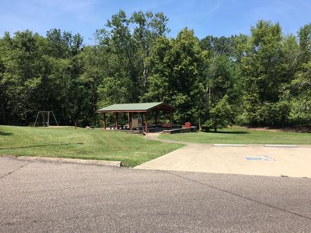
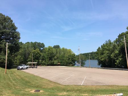
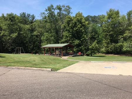
Dover is a day-use area that overlooks the lovely Lake Barkley. Whether it’s a gathering of family or friends, visitors can enjoy nature at its best in one of the country’s greatest freshwater recreational complexes.

Recreation

Boating, fishing and picnicking are popular activities at Dover day-use area. Wildlife including the occasional deer, raccoon or golden eagle, are commonly spotted in the area.

Facilities

The group picnic shelter accomidates about 35 people and 10 vehicles. The facility has lights and electricity and a water spigot.

Natural Features

Lake Barkley, the westernmost lake on the Cumberland River, sits among wooded rolling hills. The lake is connected by canal to Kentucky Lake, a reservoir that stems from the Tennessee River.

Nearby Attractions

Dover is close to Fort Donelson National Battlefield, where the Union Army won their first battle of the Civil War.

Shopping, grocery stores and gas stations are conveniently located nearby.

Reservation

More from CampingHiking.net:

EASLEY CAMPGROUND, Idaho Campground Images, Info & Reservations

Listen Directions From Ketchum, take Highway 75 north for 14.1 miles. Turn onto Forest Road 160 at the sign for Easley Campground. Phone 928-537-8888 Activities BIKING, CAMPING, FISHING, HIKING, WILDLIFE VIEWING, SWIMMING SITE Keywords EASL,SAWTOOTH NF – FS Related Link(s) Rec Area Info & Images Idaho State Road Conditions Forest

JOHN SPALDING REC AR, Missouri Campground Images, Info & Reservations

Listen Directions From Hannibal, MO, travel west on Highway 36 for 17 miles. Turn south on Route J, and travel 6 miles. Turn west on Oakland Drive and travel for 2 miles. Phone 573-735-4097 Activities BIKING, CAMPING, HIKING, SWIMMING SITE Keywords JOSR,CLARENCE CANNON DAM,SPALDING BEACH,MARK TWAIN LAKE,MARK TWAIN LAKE Related

SHRODE LAKE CABIN, Alaska Campground Images, Info & Reservations

Listen Directions Access by float plane is 45 minutes from Anchorage and 55 minutes from Cordova. By boat the trip is 25 miles from Whittier into Long Bay, then an additional one-mile hike on a trail to reach the lake. The trailhead at Long Bay is very tidal dependent and

MOOSE CREEK CABIN, Montana Campground Images, Info & Reservations

Listen Directions From Helena, take U.S. Highway 12, and travel west for 7 miles to Rimini county road. From this intersection, take Rimini Road to the south approximately 4 miles to the cabin. It is located on the east side of the road just past the entrance to Moose Creek