LOVE, TX Campground Reservation, Info, Images, Map, Directions

LOVE, Texas Campground Images, Info & Reservations

Directions

From Ennis, Texas: From Interstate 45, exit onto U.S. Highway 287 Bypass (exit #247). Travel 4.5 miles and exit at the Bardwell Lake exit sign. Turn left onto Highway 34 and go 0.2 miles. Turn left onto Lakeview Road. Travel 2.0 miles to the intersection of Beach Road. Make a slight turn to the right then proceed straight on Beach Road 0.4 miles to the park entrance.

Phone

972-875-5711

Activities

BOATING, CANOEING

Keywords

LOVE,BARDWELL LAKE,LAKE BARDWELL,BARDWELL,LOVE PARK,BARDWELL LAKE

Related Link(s)

Rec Area Info & Images

Texas State Road Conditions

Texas State Tourism

Overview

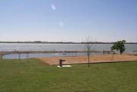
Love Park is on the southeastern shore of Bardwell Lake, less than an hour south of the Dallas-Fort Worth area in north-central Texas.

The lake has favorable fish and wildlife habitats, providing plenty of opportunities for fishing and hunting, and great locations for camping, boating and hiking. Deer, armadillo, rabbit, squirrel and a variety of bird species inhabit the area.

Recreation

Many local fishermen consider Bardwell Lake one of the best kept secrets in the state. Bass fishermen seldom leave empty-handed. Crappie fishing is moderate, and catfish are usually excellent.

The lake has a marina with fishing piers, two of which are enclosed (a small fee is charged for the use of these facilities), and there are several designated hunting areas around the lake, including those for duck hunting.

Facilities

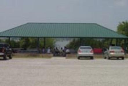
Love Park offers one reservable group picnic pavilion that can accommodate up to 200 people. The facility also provides vault toilets and a four-lane boat ramp.

Natural Features

The park is grassy and partially forested. The lake’s blue water provides a refreshing break from the Texas heat, while bright bluebonnets and other wildflowers surround the lakeshore each spring.

Nearby Attractions

Numerous amenities, as well as cultural and historical attractions, lie in the nearby cities of Dallas and Fort Worth.

Reservation

More from CampingHiking.net:

KEYESPORT REC. AREA, Illinois Campground Images, Info & Reservations

Directions From I-70, take State Route 127 south for 10 miles. Turn east on Clinton Road, continue east for four miles to the town of Keyesport, then follow signs to the recreation area. Phone 618-594-5253 Activities BOATING, CAMPING, FISHING, SWIMMING SITE Keywords KEYS,CARLYLE LAKE Related Link(s) Rec Area Info &

DAMSITE, Missouri Campground Images, Info & Reservations

Directions From Springfield, MO, take US 65 north for 60 miles to Preston, MO.. Continue on Highway 54 west to Hermitage, MO., then take Highway 254/ 64 south to Carsons Corner and follow Highway 254 west toward the dam. The entrance to Damsite Park is on the south side of

SMITH RAPIDS, Wisconsin Campground Images, Info & Reservations

Directions From Fifield, travel east on State Highway 70 for a little more than 12 miles and turn left (north) onto Forest Service Road 148. Continue for 2 miles to the campground. Phone 715-762-2461 Activities BOATING, CAMPING, FISHING, HIKING, HORSEBACK RIDING Keywords SRAP,CHEQUAMEGON-NICOLET NF – FS Related Link(s) Rec Area

KADAKE BAY CABIN, Alaska Campground Images, Info & Reservations

Directions Access is by boat (13 miles from Kake), or float plane (39 miles from Petersburg). Float planes generally land near the mouth of the bay and require up to a 2-mile hike across the tide flat. An 18-foot or higher tide is required for direct boat or float plane

SUNRISE CABIN, Virginia Campground Images, Info & Reservations

Directions From I-81, take exit 80 (Fort Chiswell) and go east on US 52 for about 1 mile. Turn right and drive south on VA 94 for about 12 miles to the intersection of the Virginia Highlands Horse Trail. Turn right onto a gravel road marked with orange diamonds (this