

Directions
Access to the cabin is by hiking only. Visitors must hike 4.2 miles on the Power Creek Trail to reach the facility.
Due to construction along the beginning of Power Creek trail, hikers and cabin users are being detoured onto the new Power Creek Valley access road. This road joins the trail after 2 miles. The detour adds 1 mile to the distance to the cabin, making it a 5.2 mile hike. Please observe all posted signs.
Phone
1 (907) 424-7661
Activities
BIKING, CAMPING, FISHING, HIKING, WILDLIFE VIEWING
Keywords
POCR,CHUGACH NF – FS
Related Link(s)
Overview
Power Creek Cabin, in the Chugach National Forest, is located 4.2 miles from Power Creek Trailhead, which is located approximately 6.9 miles north of Cordova, Alaska on the Power Creek road. The trail provides scenic terrain for hikers. Access to the cabin is by hiking only. It is a 4.2-mile hike along Power Creek Trail. Visitors are responsible for their own travel arrangements and safety, and must bring several of their own amenities.
Recreation
Power Creek Valley is a great spot for hikers. Both Power Creek Trail and Crater Lake Trail begin just outside Cordova and can be hiked separately, or as part of a 12.5-mile loop. The trail meanders through spruce-hemlock forests, traverses a difficult exposed ridge and treats hikers to scenic views of Orca Inlet, Eyak Lake and the Delta. Time spent at Crater Lake is worth the effort.
From Cordova, mountain bikers will find a relatively flat ride that follows the northern shore of Eyak Lake, then parallels the creek through a rainforest setting past several waterfalls, heading toward the coastal Chugach Mountain Range. The southern exposure of the mountains and the amount of wildlife on the trail makes it a fantastic ride. During the summer and fall when there are salmon in the lake and creek, it is a popular bear feeding area.
Hunters can take advantage of a long hunting season in the surrounding national forest. Bear season occurs during spring and fall, while deer season begins in late summer and lasts through late fall.
There isn’t much fishing in the cabin’s vicinity, however some small Dolly Varden can be found in the stream near the cabin.
Facilities
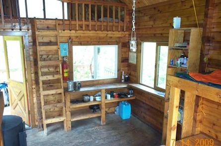
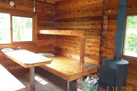
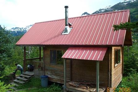
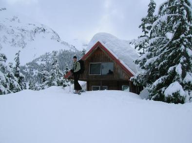
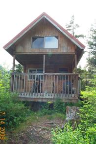
The 12×20-ft, rustic cabin has a loft and a covered deck. It is equipped with wooden bunkbeds without mattresses that sleep up to eight guests. The cabin is furnished with a table, oil stove for heat, rainwater catchment barrel and an outdoor pit toilet. The cabin does not have running water or electricity. Visitors must bring their own water, food, sleeping bags, sleeping pads, cook stoves, matches, cooking gear/utensils, lanterns or flashlights, toilet paper, first aid kit and garbage bags. The oil stove burns either #1 stove oil or kerosene and this must be provided by visitors. Click here for more cabin details.
Natural Features
Dense forests, glacier-fed streams, valleys and rocky peaks define the landscape around the cabin, providing habitat for an abundance of wildlife. At an elevation of 500 feet, Power Creek Cabin is nestled in a spruce-hemlock forest above Power Creek Valley, where visitors can view wildflowers and wildlife. Steep mountains rise from the valley floor. Mountain goats, brown bear, black bear, moose and waterfowl are all found in the area.
The closest town to Power Creek Cabin is Cordova. Located at the base of glacier-capped peaks and facing Prince William Sound, Cordova is a commercial fishing community, home to the world famous Copper River Wild Salmon. The town is a treasure, steeped with natural features and cultural history.