


Directions
The cabin is located on Winstanley Lake approximately 33 air miles northeast of Ketchikan on the mainland, east of Winstanley Island. The cabin is accessible by float plane or by trail from saltwater (skiff provided at end of trail; please return it to the trail after use). Access by boat involves a 2.5 mile (4 km) hike from salt water plus a 2.25 mile (3.6 km) row to the cabin. Refer to USGS Ketchikan B-3. In fall, winter, and early spring, the cabin may be inaccessible due to frozen lake surface (float planes cannot land). Please contact the Ketchikan-Misty Fjords Ranger District for information prior to making reservations during these periods. This cabin is in a designated Wilderness area, and access by helicopter is illegal.
Phone
907-225-2148
Activities
BOATING, HISTORIC & CULTURAL SITE, CAMPING, FISHING, HIKING, HUNTING, WILDLIFE VIEWING
Keywords
WIAN,TONGASS NF – FS
Related Link(s)
Overview
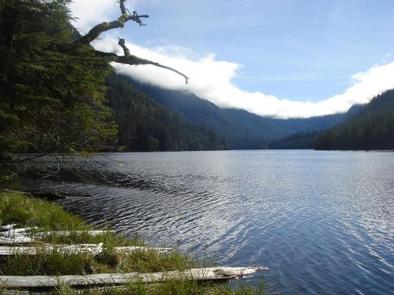
Winstanley Lake Cabin is located on the mainland on the shore of its namesake lake approximately 33 air miles northeast of Ketchikan. The cabin offers recreational and wildlife viewing opportunities and makes an excellent base for experiencing this corner of Alaska.
The cabin is remote and accessible only by float plane or boat, depending on conditions. Access by boat involves a 2.5 mile hike from saltwater plus a 2.25 mile row to the cabin. Visitors are responsible for their own travel arrangements and safety, and must bring several of their own amenities.
Recreation
A 14-foot aluminum skiff with oars is provided for rowing around the lake, but visitors must provide their own life jackets. Visitors can row to the historic Winstanley Lake Shelter at the end of the lake, which was built by the Civilian Conservation Corps in the early 1930s.
Anglers can fish for cutthroat trout and kokanee salmon in the lake. Hunting is possible for Sitka black-tailed deer, mountain goat, black bear and brown bear with the proper permits.
Facilities
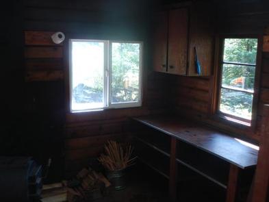
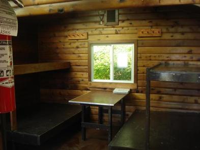
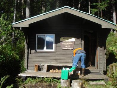
The 12×14-ft. ( pan-abode style ) log cabin accommodates 6 people with 2 single and 2 double bunks. Other amenities include a table and benches, a cooking counter, food storage, broom, and wood stove. An outhouse is located nearby. NOTE: Firewood may be available, but visitors are encouraged to contact the Ketchikan Misty Fjords Ranger District to check the status of the woodshed. Drinking water and electricity are not available. Visitors must bring their own water supply, but water is also available from the lake and should be treated before drinking or cooking with it ( water safety ). Visitors should also bring sleeping bags, sleeping pads, cooking gear, lanterns or flashlights, food, toilet paper, garbage bags, a fire extinguisher and fire starter. Rain gear and boots are recommended. Visitors are expected to pack out their trash, gear and food and clean the cabin before leaving. Click here for more cabin details and maps.
Natural Features
The cabin is located within the Misty Fiords National Monument Wilderness. It is backed by a forest of large old-growth spruce, hemlock and cedar and offers views of the placid lake with its forested shoreline and surrounding mountains.
The Misty Fiords Monument Wilderness supports a diverse variety of wildlife. Mountain goats, bears, deer, moose and bald eagles make their home here (bear safety). Many species of birds may be seen in or around the lake.