


Directions
Accessible by boat or float plane, 24 miles from Petersburg. The cabin may also be reached by hiking the 2.75-mile trail from Kah Sheets Lake, which is accessible by float plane only. Due to changes in Kah Sheets Creek near the cabin, visitors will need at least a 16-foot tide and up to an 18-foot tide to navigate the area in front of the cabin, dependent on conditions. Deposition from the creek has created gravel bars which have made access more difficult. Refer to USGS topographic map Petersburg C4. Maps are available online or by calling the Petersburg Ranger District at (907) 772-3871. Please visit or call the Petersburg Ranger District at (907) 772-3871 with questions or to report vandalism or missing amenities.
Phone
907-772-3871
Activities
BOATING, CAMPING, FISHING, HIKING, HUNTING, WILDLIFE VIEWING
Keywords
KAHB,TONGASS NF – FS
Related Link(s)
Overview
Kah Sheets Bay Cabin sits on coastal waters in the islands of southeastern Alaska. It is remotely located, offering solace and seclusion to visitors, but also access to great fishing, hunting and wildlife viewing.
The cabin is accessible by boat or float plane, or may be reached by hiking the 2.75-mile trail from Kah Sheets Lake, which is accessible by float plane only. Visitors are responsible for their own travel arrangements and safety, and must bring several of their own amenities.
Recreation
The hike to Kah Sheets Lake is an easy 2.75 miles on a boardwalk, with opportunities to explore two access trails leading to waterfalls, as well as wildlife viewing and fishing access. Additionally, hiking is possible on the remains of old logging roads. Anglers will find excellent fishing for steelhead, trout and salmon (pink, sockeye and coho). Bear, grouse and waterfowl hunting is possible in designated areas.Be aware of wildlife in the area and learn about bear safety . More leisurely pursuits include shorebird viewing in early May and beachcombing. Due to changes in Kah Sheets Creek near the cabin, visitors will need at least a 16-foot tide and up to an 18-foot tide to navigate the area in front of the cabin, dependent on conditions. Deposition from the creek has created gravel bars which have made access more difficult. (View local tide charts).
Facilities
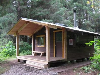
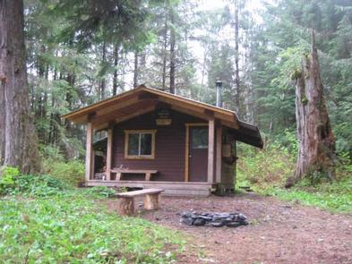
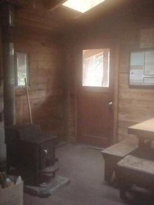
The hunter-style cedar log cabin is equipped with four single wooden bunks, a table, benches, oil heater and wood stove. Skylights and a covered porch were added to the cabin in recent years, and an outhouse with a pit toilet is provided. Firewood for the stove is typically available, but not guaranteed. A broom, dust pan, axe and splitting maul should be available, but may be missing or damaged. Drinking water is not available at the cabin. Visitors are advised to bring their own water supply, but a nearby creek also provides a source of water. All water collectedfrom natural sources should be treated or boiled before using. Heating oil is not supplied. Visitors must supply No. 1 heating oil for the clean-burning oil heater, approximately a gallon per day. Other items to bring include sleeping bags and pads, a cook stove and cooking gear, towels, food, clothing and garbage bags, among other necessities. All trash and food must be packed out, and visitors are expected to clean the cabin before leaving. Please visit or call the Petersburg Ranger District at (907) 772-3871 with questions or to report vandalism or missing amenities.
Natural Features
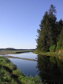
The cabin is located on the south end of Kupreanof Island at the mouth of Kah Sheets Creek in a large saltwater bay and tide flat. The name Kah Sheets derived from the Tlingit term “by the fisheries,” which is indicative of the abundance of fish that can be found here. The surrounding terrain is second-growth forest and flat muskeg, with one 776-foot hill between the bay and Kah Sheets Lake, which sits at an elevation of 100 feet. A variety of wildlife makes its home in the area, including grouse, black bears, deer, moose and waterfowl. This is a prime spot for spring bird migration viewing on the tide flat in the bay. Visitors are asked to be considerate of the state’s abundant biology and practice wildlife etiquette .