
Directions
Coming to Aspen via Independence Pass: Take Highway 82 West from downtown Aspen, 1 mile to the roundabout (rotary). From the roundabout, take Maroon Creek Road 4.7 miles to the Maroon Bells Welcome Station. Continue past the Welcome Station. The amphitheater is 5 miles beyond the Welcome Station at the end of the road. The Maroon Bells Amphitheater is approximately 9 miles from Highway 82 at the roundabout.
Coming to Aspen via Glenwood Springs: Take Highway 82 for 40 miles to the roundabout (rotary). From the roundabout, take Maroon Creek Road 4.7 miles to the Welcome Station. The amphitheater is 5 miles beyond the Welcome Station at the end of the road. The Maroon Bells Amphitheater is approximately 9 miles from Highway 82 at the roundabout.
Phone
970-963-2266; MAROONBELLS@USDA.GOV
Activities
CAMPING, INTERPRETIVE PROGRAMS, HIKING, VISITOR CENTER, WILDLIFE VIEWING, DAY USE AREA
Keywords
MBSA,Maroon Bells,Maroon Bells Amphitheatre,Maroon,Maroon Bells Day Use Area,Maroon Bells Wedding Amphitheatre,Maroon Bells Scenic Area,Maroon Bells Wedding Facility,East Maroon
Related Link(s)
Colorado State Road Conditions
Overview
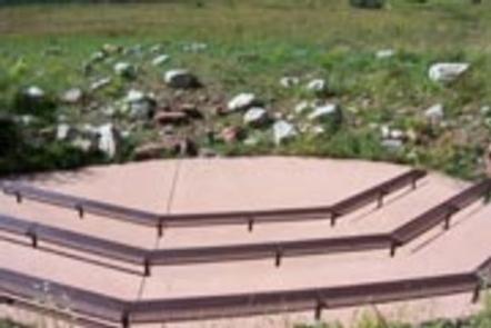
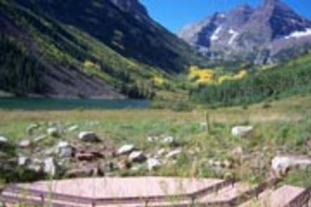
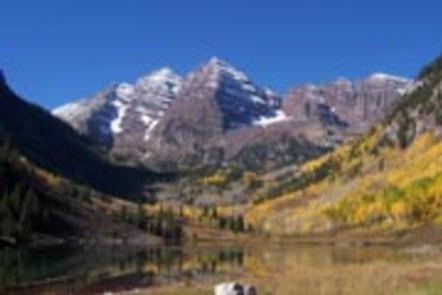
Reputed to be the most photographed mountains in Colorado, the spectacular Maroon Bells dominate this setting. Hemmed in by Maroon Lake, aspen groves and evergreen forests, Maroon Bells Amphitheater is designed for interpretive talks, and is especially popular for recreational events and weddings.
The amphitheater is available for use by the general public and can be reserved for private events. The maximum number of people allowed at the amphitheater is 50. Receptions are not allowed at this location, but can be held at the East Maroon Portal Picnic site, approximately a four mile drive.
Reservations are not accepted for Fridays and Saturdays in June, July and August; Reservations are not accepted for Fridays, Saturdays and Sundays in September and October.
Recreation
There are hiking trails of varying length and difficulty. Trails next to Maroon Lake are fairly flat and wheelchair and stroller accessible. Beyond Maroon Lake, trails become steeper and rocky.
For hikers and backpackers, the Maroon Bells-Snowmass Wilderness epitomizes the Rocky Mountains of Colorado. Starting from the Maroon Bells Scenic Area, the West Maroon Trail winds through aspen groves, crosses streams, and switchbacks through forests. Climbing to alpine terrain, backpackers will find high mountain lakes and a smattering of wildflowers in early summer. Check specific regulations for camping in the Maroon Bells-Snowmass Wilderness Area.
Facilities
Designed for interpretive programs, the amphitheater can be reserved by the general public for private events. Parking for the amphitheater is available at the day use parking area, 200 yards from the site. Accessible parking is available 50 yards away. Accessible vault toilets are available at this site; however, drinking water and electrical outlets are not.
Vehicle traffic is restricted on Maroon Creek Road from 8:00 a.m. until 5:00 p.m. past the Maroon Bells Welcome Station. Individuals who reserve this site are issued five vehicle passes which allow travel in a motorized vehicle past this point. Passes will be available for pickup at the welcome station five days prior to your event. It will be your responsibility to distribute passes and coordinate transportation with your guests.
Park all vehicles in the day use parking area. No vehicles are allowed in the bus loop for any reason.
Other options for access to the site include parking at Aspen Highlands Ski Area. The Maroon Bells shuttle bus is $8.00 per adult and $6.00 for seniors 65 or older and children under 6. Operating hours for the shuttle bus are 8:00 a.m. until 5:00 p.m. Dogs are permitted on the Maroon Bells Shuttle.
If the contact information you provide in your reservation is not correct and/or you do not respond, your reservation will be considered cancelled. In order for the coordinator to contact you must leave a full name, phone number, email address. and total number of people attending. Total number allowed is 50. Guests are required to remove all trash after event. A dumpster is located toward the far end of the day use parking area.
Receptions cannot be held at the amphitheater, but they may be held at the nearby East Maroon Portal Picnic site. The East Maroon Portal Picnic site is a small, developed area situated along Maroon Creek and can accommodate up to 75 people for the morning, the afternoon, or both. All food, beverages, and scented items must be properly stored until the time of the reception. A bear-proof food locker is available to store these items while not being attended. Click here to reserve the East Maroon Portal Picnic site.
Natural Features
The amphitheatre has views of the surrounding Maroon Bells-Snowmass Wilderness. This wilderness is one of the five original Colorado wilderness areas designated by the 1964 Wilderness Act. Its scenic value exudes from its aspen groves, meadows of wildflowers, and dark forests of spruce and fir that rise up from the valleys to alpine landscapes. Here, bighorn sheep, pika, and ptarmigan find habitat above timberline.
Towering over glacial valleys at over 14,000 feet in elevation, the Maroon Bells are the most recognizable peaks in the Elk Mountains. The Maroon Bells are unique in the Rockies in that they are made up of metamorphic sedimentary mudstone that gives the peaks their maroon color and unstable nature for climbing.