
Directions
Snyder Guard Station is located 36 road miles northeast of Bonners Ferry, ID and takes 50 minutes to drive from point to point.
From the Bonners Ferry Ranger Station, drive north on US 95 for 29.5 miles to Moyie River Road. Turn right (south) onto Moyie River Road (at Good Grief Cafe) and travel south for 5.5 miles. Snyder Guard Station is on the right and is marked with a sign. Travel time is 50 minutes from the Bonners Ferry Ranger District.
Phone
208-267-5561
Activities
BOATING, CAMPING, WATER SPORTS, SWIMMING SITE
Keywords
None
Related Link(s)
Overview
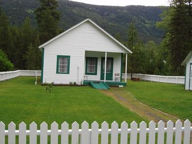
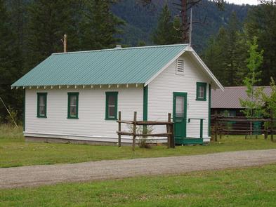
Snyder Guard station, located on the banks of the scenic Moyie River, has been listed on the National Register for Historic places since 1982. The complex of seven buildings includes a residence, two log cabins, a cookhouse, warehouse, corrals, a machinery shed and a garage. The facility is spread across 10 lovely acres and is perfect for large groups of up to 70 people or small family getaways.
The buildings on the property were constructed from 1906 to 1936, and most structures are available for rent. A group picnic and camping area provide additional campsites and amenities for six RVs, plenty of room for tent camping, pathways to the river, and more.
Snyder was originally constructed as a remote work station for early Forest Service employees. As roads were constructed and transportation improved, the site no longer required live-in crews, so visitors can now use these buildings as recreation rentals.
Recreation
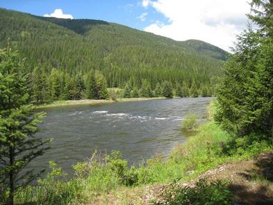
Outdoor recreational opportunities abound on the Moyie River and nearby lakes. Fishing, whitewater rafting, canoeing and kayaking are all popular pastimes.
Over 70 miles of trails are open to hikers, mountain bikers, horseback riders, and motorcyclists. The Copper Falls viewpoint trail is just a few miles from the Snyder Guard Station on copper Falls Road #2517. Hunting, huckleberry picking, cross country skiing and snowmobiling are enjoyed in season.
Facilities
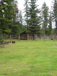
Historic Site buildings include the main ranger house, two small log cabins, a cookhouse, a horse pole barn, and several administrative buildings. Camping Loop buildings include a 50′ x 30′ covered picnic shelter, a camping loop with six sites with picnic tables and fire rings, a vault toilet, and additional parking for 10 vehicles. Additionally, two horse corrals, vault toilets, drinking water faucets, campfire rings, picnic tables, and a mowed grassy playing field are available for use.
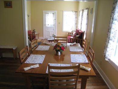
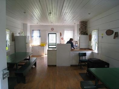
The ranger house has three bedrooms, a bathroom with a flush toilet and hot shower (low capacity, only for groups under 25 people, outdoor screened shower areas are also available), a living room, dining room, and a fully stocked kitchen with enough utensils for 12 guests. The small cabins come with three to four beds and a table and chair. These cabins have no electricity. Most facilities and furnishings are 80-110 years old, please use them gently and treat them with respect. To protect the historic features, pets are not allowed at Snyder Guard Station.
The cookhouse is furnished with benches and tables to seat 30, plus cookware and place settings. Outdoor amenities include picnic tables and campfire rings at six sites and a large picnic shelter with a fireplace and grills.
Campers should bring basic camping gear like bedding or sleeping bags, flashlights, food, matches, garbage bags, towels and dish soap. (Click here for more cabin details.)
Natural Features
Snyder Guard Station is located within the Lower Kootenai River Area (Bonners Ferry District) of the Idaho Panhandle National Forests. The area is bordered by the Purcell and Cabinet Ranges and the Montana Line on the east, the rugged Selkirk Range on the west, and the Canadian border to the north. The Kootenai River meanders north and west through the District, and the Moyie River joins it from the north.
The Guard Station sits at an elevation of 2,500 feet along the Moyie River, 8 miles south of the Canadian border. Terrain in the river valley is relatively flat, and is bordered by Queen Mountain to the West and Ruby Mountain to the east.
The mixed conifer forest include Douglas fir and spruce. Wildlife sightings include elk, deer, black bears, moose and bald eagles.
Nearby Attractions
A restaurant, gas station and convenience store are less than 10 miles down the road.