
Directions
The Manzanita Lake Camping Cabins are located approximately one hour east of Redding in Northern California. Redding is approximately three hours north of Sacramento on State Highway 5 and approximately 4.5 hours from the San Francisco Bay Area. From Redding, drive 48 miles east on State Highway 44. Turn right into Lassen Volcanic National Park and continue one mile south to the Manzanita Lake Campground, Camper Store and Cabins.
Phone
530-779-0307
Activities
BOATING, HISTORIC & CULTURAL SITE, CAMPING, FISHING, HIKING, PICNICKING, DAY USE AREA, SWIMMING SITE, OTHER RECREATION CONCESSION SITE, PADDLE BOATING, KAYAKING, CANOEING, WATER ACCESS, AMPHITHEATER
Keywords
Lassen Volcanic National Park
Related Link(s)
California State Road Conditions
Overview
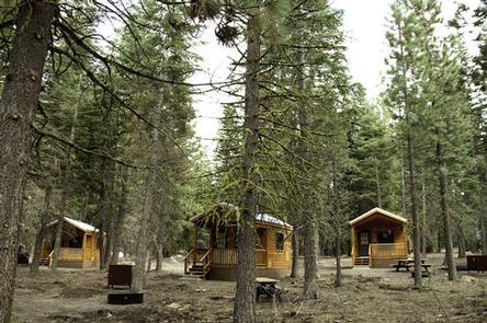
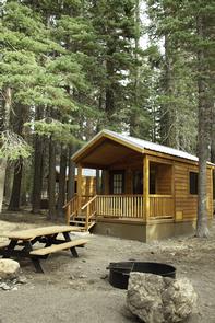
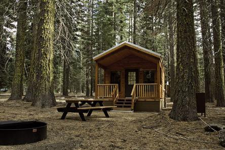
Situated near the northwest entrance to the park, the rustic Manzanita Lake Camping Cabins offer convenience and comfort in the scenic setting of Lassen Volcanic National Park. These 20 cabins are the first new accommodations in Lassen Volcanic National Park since 1972, and are available in three models: 2 Room, 1 Room, and Bunkhouse. They are within walking distance of Manzanita Lake, a popular fishing and family destination, and offer a view of 10,457-foot Lassen Peak, the largest volcano in the park.
The cabins are located one mile south of the park entrance, perched at an elevation of 5,890 feet and adjacent to a 179-site campground. The Loomis Museum, Loomis Ranger Station and popular hiking trails are nearby. Educational programs are presented at the museum and amphitheater within the campground.
Groceries, supplies, gifts, gasoline, a pay phone, ATM, laundromat and hot showers can be located at the nearby Manzanita Lake Camper Store. Our cafe features a variety of delicious and healthy items including salads, fresh fruits, hot or cold sandwiches, espresso drinks and soft-serve ice cream. Kayak, canoe and paddle board rentals are also available on a first come, first serve basis at the Camper Store.
A map of our cabins can be viewed under additional information or on our website, www.lassenlodging.com.
Follow us on Facebook at www.facebook.com/ManzanitaLake.
Recreation
Manzanita Lake is popular with fly fishermen for its trout; however, the area does maintain a catch-and-release policy and requires the use of artificial lures and single barb-less hooks only. Non-motorized boating is permitted and kayak rentals are nearby.
The park boasts more than 150 miles of hiking trails, a variety of which can be accessed from the campground, including family-friendly hikes as well as those for more experienced hikers. Manzanita Lake is also a favorite spot for birders.
Facilities
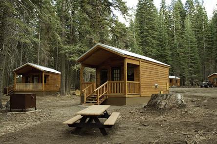
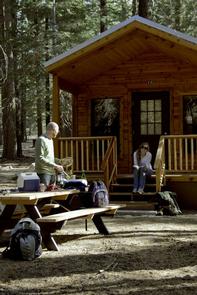
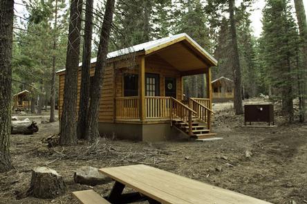
There are a variety of cabin types available, including a one-room cabin that sleeps three, a two-room cabin that sleeps six, and a one-room bunkhouse that sleeps up to eight people.
Each cabin has a double bed and/or bunk beds with a three inch firm mattress, propane heat, lockable door, lantern, picnic table, fire ring and a bear-proof food storage locker. These are rustic cabins with no bedding or linens provided, so please bring your own. The one-room and two-room cabins also have a table and chairs.
Please note that the one-room cabin has a double bed that sleeps two, with a third person on the floor in a sleeping bag,
Restrooms, showers, a laundromat and a camper store with souvenirs, food, camping supplies and fuel are located within a short walk from the cabins. Showers are quarter operated and cost $1.75 for three minutes. A timer will then buzz and you can add more quarters for additional time. A change machine that accepts one and five dollar bills is located in the laundromat attached to the Camper Store,
Natural Features
Lassen Volcanic National Park is known for its volcanic history, as well as its diversity of plants and animals. It contains 300 active volcanic domes and many hydrothermal features, such as mud pots and steam vents. Lassen Peak is the southernmost active volcano in the Cascades and the second most recent volcano to erupt in the lower-48 of the United States before Mount St. Helens.
Lassen Volcanic National Park boasts over 700 species of flowering plants and 250 native species including birds, mammals, reptiles and fish. The park is at the junction of the Cascade Range, the Sierra Nevada mountains and the Great Basin, thus providing many unique habitats. The Manzanita Lake Camping Cabins lie within a ponderosa pine forest.
Nearby Attractions
The Loomis Museum is at the north end of the park and the Kohm Yah-mah-nee Visitor Center is at the south end of the park. Both offer information, photos and videos of some of the most popular hikes in the park, along with a movie about the history of Lassen Peak eruptions. When visiting the Kohm Yah-mah-nee Visitor Center at the south entrance of the park, please visit us at Lassen Cafe & Gift. If interested in booking a stay with us at Drakesbad Guest Ranch, please visit www.lassenlodging.com.