


Directions
Important note regarding GPS use: please be advised that GPS units can, and have sent guests down the wrong roads to access the Lookout. Please consider following the directions below rather than your GPS unit. Directions: From Canyonville take West 1st Street and turn onto SE 3rd St/OR-227. Continue to follow OR-227 approximately 23 miles until you reach Tiller. From Tiller, travel northeast on Douglas County Road #46 which becomes South Umpqua/Forest Service Road #28, for 18.5 miles to Buckeye Creek/Forest Service Road #29. Follow Forest Service Road #29 for 7 miles to the junction with Forest Service Road #2838. Turn left (north) onto Forest Service Road #2838 for 1.5 miles to the Forest Service Road #2838-950. (On the left) Follow the Forest Service Road #2838-950 for 1.5 miles to the trailhead. The Acker Rock Trail #1585 is 0.4 mile and requires a moderate to steep hike to reach the lookout. Forest Service Road #2828-950 road is closed with a locked gate. Vehicle access past the road gate is permitted with your reservation, but other users may hike from the gate to the lookout during your stay. Placing personal locks on the gate is not permitted as agency personnel may need to access the site.
Phone
541-825-3100
Activities
CAMPING, HIKING, WILDLIFE VIEWING
Keywords
None
Related Link(s)
Overview
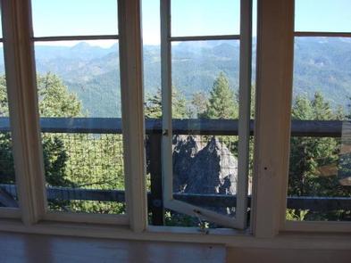
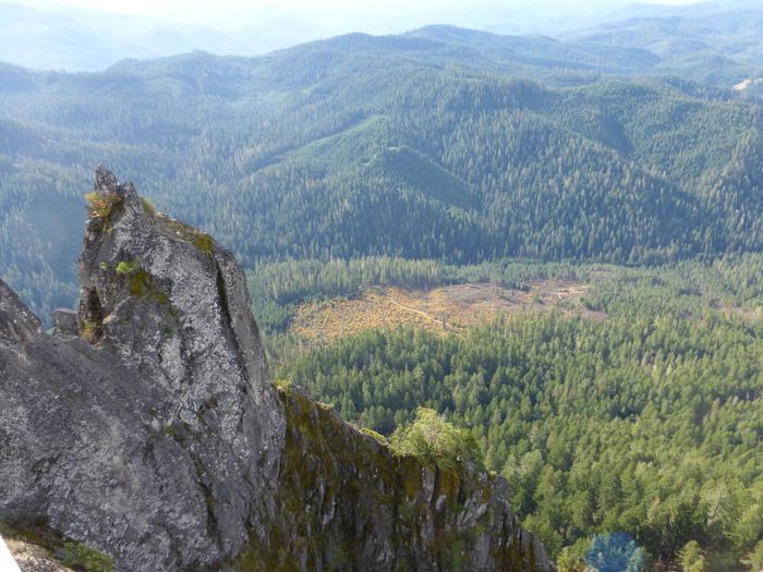
Perched atop the edge of a rocky cliff in the Umpqua National Forest, Acker Rock Lookout offers visitors a unique lodging experience with spectacular panoramic views of the South Umpqua watershed in southwest Oregon. Still used in active fire detection today, the lookout was placed on the rocky cliff via helicopter in the 1960’s. Before the advent of airplane surveillance for fire detection, there were more than a dozen lookouts on the Tiller Ranger District. Today Acker Rock and Pickett Butte are the only remaining lookouts on the District. The lookout tower is generally available for reservation from August 1st thru November 15th (depending on snow). High clearance all-terrain vehicles are recommended for travel to this site, and guests must bring several of their own amenities. The lookout is not rented during the winter months due to wind and snow weight restrictions on the building. Visitors should keep in mind everything must be packed in via a moderately steep 0.4-mile hike along a forested trail to reach the lookout.
Recreation
The panorama includes landmarks on the Rogue-Umpqua Divide; on a clear day you can see mountains on the Willamette, Rogue, and Deschutes River watersheds and Crater Lake Rim. Overlooking the Umpqua River and several of its tributaries, the lookout is a delightful setting for hiking, birding and wildlife viewing. Seasonal changes envelope the area as snowmelt gives rise to spring flowers and vivid autumn colors bring with it numerous recreation opportunities.
For a day trip, guests may enjoy a scenic drive along a portion of the 172-mile Rogue-Umpqua National Scenic Byway or a mountain hike into the Rogue Umpqua Divide wilderness on over 100 miles of trail.
Facilities
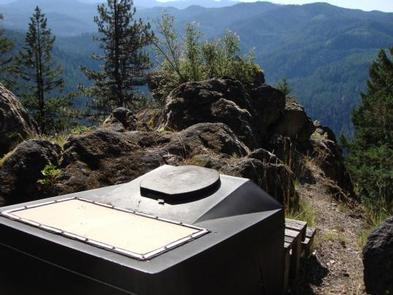
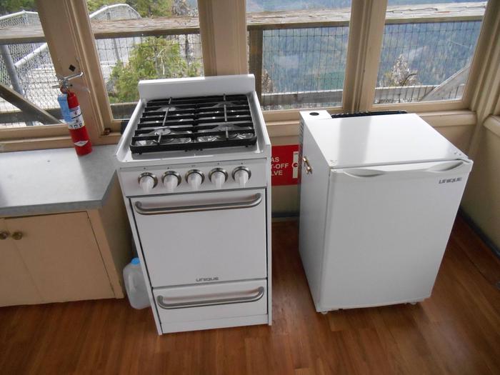
The 12-foot by 12-foot, one-room lookout is furnished with a single bed, a small table and chair, and is equipped with a propane fueled wall heater, lanterns, cooking stove with oven and a refrigerator (propane is provided). A composting toilet is located at the lookout site. There is no water at the site, so visitors must bring plenty for drinking, cooking and washing. Potable water is available at a spigot in front of the Tiller Ranger Station office (45 minute drive). Guests must supply their own food, cooking utensils, sleeping bags, sleeping pads, towels, dish soap, matches, cooking gear, toilet paper and garbage bags. Although propane lighting is available, bringing an additional light source is recommended.
Natural Features
Unique volcanic and sedimentary rock outcroppings and dense conifer forests define the landscape, giving way to sub-alpine meadows and summer wildflowers in the higher elevations. The rock formation on which the lookout building sits is itself a magnificent feature. Sheer cliffs drop off for several hundred feet on the west and south sides.
The translation of the word “Umpqua,” meaning “thundering waters,” defines the area. High mountain lakes, heart-stopping rapids, peaceful ponds and thundering waterfalls await visitor.
Nearby Attractions
Opportunities for fishing are within 10 miles of the lookout.