


Directions
From Hood River, Oregon, travel south on Highway 35 for 8.5 miles, past the Hood River Ranger Station. Look for the Cooper Spur Inn sign and turn right off Highway 35, just north of Olallie Trailhead, onto Forest Road 3510 and drive to Copper Spur Inn. Turn left at the Cloud Cap/Tilly Jane Road 3512. The first trailhead is just past the intersection with Forest Service Road 620, with parking on the right and the trail on the left side of the road. The second option is to follow the Cloud Cap Road (FS Road 3512). This is the 9 mile gently sloping road.
The safest way to ski down is the Cloud Cap Road (FS Road 3512). This can be a long (9 mile), extremely difficult slog if there is soft snow. The Old Wagon Road shortens this distance by about 4 to 5 miles, but involves steep slopes in the upper section of the road. The shortest route and probably the safest in poor snow conditions is to ski or walk down the Tilly Jane Ski Trail, a distance of 2.7 miles.
Phone
RESERVATIONS@TILLYJANECABINS.ORG
Activities
HISTORIC & CULTURAL SITE, CAMPING, HIKING, WINTER SPORTS, WILDERNESS, ICE CLIMBING, MOUNTAIN CLIMBING, SLEDDING, SKIING
Keywords
Guard Station,Cloud Cap Guard Station
Related Link(s)
Overview
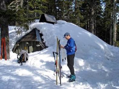
Tilly Jane Guard Station is an ideal getaway for individuals and families who enjoy the great outdoors in the beautiful Pacific Northwest. It is one of the oldest structures on Mt. Hood and provides shelter for warmth and an escape from the elements while participating in a variety of activities, specifically winter-related recreation. During the winter months it serves as a winter retreat for visitors hardy enough to access the cabin from the Tilly Jane Sno-Park.
Guests can access the cabin following a 9-mile, gently sloping road, or via the historic Tilly Jane Ski Trail, which is roughly 2.7 miles with an elevation gain of 1,900 feet. Skis with skins or snowshoes are highly recommended and travelers should be prepared for extreme weather conditions. The TJ Ski Trail is poorly marked due to the 2008 Gnarl Ridge Fire so be on notice. Guests should be experienced in backcountry travel and survival skills. Guests must also bring several of their own amenities.
Recreation
Visitors to the Guard Station enjoy a variety of recreational activities, including hiking, snowshoeing and backcountry skiing, which can be done most of the year due to high levels of snowfall in the area. Many trails exist in the area, prompting exploration. Most trails are not marked so visitors should be familiar with the area. Above the tree line, visitors can catch a glimpse of Mt. Adams, St Helens, Mt. Rainier and the Hood River Valley flanked by the dry high desert of eastern Oregon.
Facilities
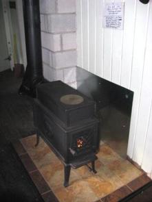
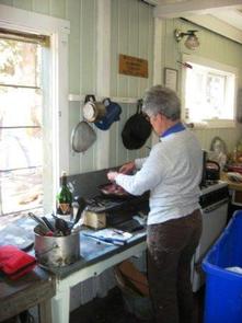
The cabin accommodates up to 8 people. It includes a full kitchen and a second story sleeping loft with pads. It has propane lighting and a cooking stove/oven, as well as all cooking pots and utensils. A variety of seating is available, as well as a table and chairs. A fireplace and woodstove with firewood are also provided. An on-site pit toilet is located within the wood room of the cabin. Water is obtained by melting snow or by digging an access hole to Tilly Creek. We recommend all water be treated.
Guests will need to bring their own bedding, clothing, food, garbage bags and toilet paper. A variety of house rules exist, including proper closure of the cabin, which involves shutting off the gas, reinstalling the shutters and locking the cabin up. The cabin will need to be cleaned prior to leaving, dishes washed and everything in its place. Guests will also need to replenish a supply of wood and kindling for the next group. All food and garbage must be removed from the cabin.
Natural Features
The Guard Station is located high on the northeast side of Mt. Hood at an elevation of 5,700 feet. It was built in 1934 and initially received seasonal use for back country access and fire protection. The cabin is one of five structures in the area built in the 1930s by the Civilian Conservation Corps and is part of the Cloud Cap/Tilly Jane Historic District. The facility is operated and maintained by the volunteer organization, Oregon Nordic Club, under a permit from the U.S. Forest Service.