

Directions
Renters should check winter road reports online at 511.idaho.gov or by calling 511 or 1-888-432-7623 prior to travel.
October 15, November 30:
From Stanley: Intersection of Hwy 21 and Hwy 75, drive south on Hwy 75 4.25 miles to Redfish Lake Road (FS Road 214). The turn is near mile marker 185, approximately 5 miles south of Stanley.
From Ketchum/Sun Valley: Drive north 55 miles on Hwy 75 to Redfish Lake Road. Hint: The turn is near mile marker 185. If you reach Stanley, you’ve gone about 5 miles too far north. From Hwy 75 and Redfish Lake Road (FS Road 214), drive 2 miles (southwest) along FS Road 214 to Redfish Visitor Center, park at Visitor Center, walk around Visitor Center to Redfish Amphitheater. Redfish Cabin is 30 yards south of amphitheater.
December 1 – April 15:
From Stanley: Intersection of Hwy 21 and Hwy 75, drive south on Hwy 75 4.25 miles, parking area is on the left (east side of Hwy) just before Redfish Lake Road near mile marker 185, approximately 5 miles south of Stanley.
From Ketchum/Sun Valley: Drive north 55 miles on Hwy 75, parking area is on right (east side of Hwy) just after Redfish Lake Road near mile marker 185. If you reach Stanley, you’ve gone about 5 miles too far north.
From Parking Area: Ski, snowshoe, or snowmobile 2.25 miles along Redfish Lake Road (FS Road 214) past turnoff to Redfish Lodge, past Redfish Visitor Center to where FS 214 comes close to lakeshore; turn right (west) on foot path for about 200 yards. Redfish cabin will be on the right (north) before crossing Fishhook Creek.
Phone
208-774-3000
Activities
BIKING, BOATING, CLIMBING, HISTORIC & CULTURAL SITE, CAMPING, HORSEBACK RIDING, HUNTING, WINTER SPORTS, VISITOR CENTER, FISH HATCHERY
Keywords
Redfish Cabin,Redfish Lake Cabin,Red Fish Cabin,Red Fish Lake Cabin
Related Link(s)
Overview
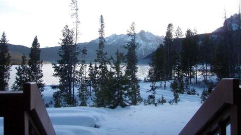
A stay at the historic Redfish Cabin is like having your own private Idaho! Nestled in the trees above the northern shore of Redfish Lake at an elevation of 6,570 feet, the historic (Civilian Conservation Corps 1930’s era) cabin offers a perfect getaway for a small family or group of friends. The cabin is warm and cozy, the views are breathtaking, recreation opportunities abound and starry nights provide a gateway to heaven. And you can share it all with your canine family member.
The Sawtooth National Recreation Area was established in 1972 for its natural, scenic, historic, pastoral, and fish and wildlife values. Redfish Lake is by far the most popular location in the area; however, a fall or winter visit provides a totally different experience than the "Cony Island" atmosphere of summer. Available only in the fall and winter, this is a special time of year where few visitors come to enjoy the beauty and solitude of the lake and surrounding mountain peaks.
Recreation
The cabin provides easy access to a variety of recreation opportunities. In the fall, trailheads to Bench Lakes, Redfish Creek, Fishhook Creek, and Marshall Lake, all within half a mile of the cabin, offer access to fabulous hiking or horseback riding. Snowshoeing and cross-country skiing on un-groomed trails near the lake offer excellent opportunities for winter recreation. Quick access to the groomed Stanley to Smiley Creek snowmobile route affords motorized recreation opportunities. Whether its photography, bird watching, climbing a mountain or sitting by the fire with a book, there’s an activity for all.
Facilities
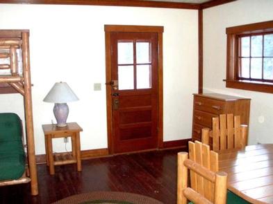
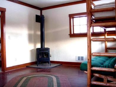
Redfish cabin can accommodate three people on a log bunk bed/futon (single mattress above, double mattress below). More people can sleep on the floor in sleeping bags (bring your own bags and pads) for a maximum of six persons.
Winter access (after November 30) is a 2.25 mile snowmobile, snowshoe or ski along the gently climbing Forest Road 214.
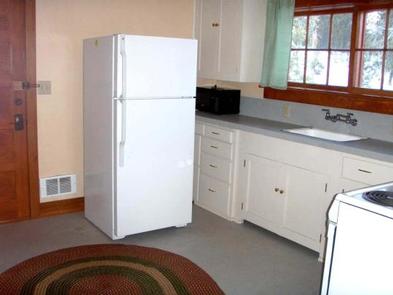
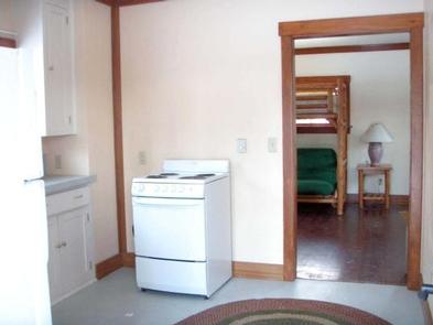
The cabin is equipped with electric lights. The heat source is a gas fireplace in the living room and electric wall heaters. The kitchen features an electric stove, refrigerator, microwave, coffee pot, pots and pans, dishes and utensils. There is no running water. There is an outhouse 50 feet from the cabin. There are picnic tables and a fire ring at the cabin although these might be buried under the snow in the winter.
The front porch offers stunning views of the Sawtooth Wilderness and Redfish Lake.
Natural Features
Named for the brilliant sockeye salmon that return each year after a 900 mile journey from the sea, Redfish Lake is the largest lake in the Sawtooth National Recreation Area. These fish were in such numbers that it’s said the lake would shimmer red. Now endangered, most of the sockeye returning to the lake are bred in the nearby Sawtooth Fish Hatchery.
The 217,000 acre Sawtooth Wilderness provides the backdrop for this dramatic setting, including the peaks which frame the lake at its south end: Mount Heyburn at 10,229′ (3,118 m) and Grand Mogul at 9,733′ (2967 m). Known for clear air, clean water and classic alpine beauty, this wilderness is home to a diversity of wildlife including bald eagles, osprey, elk and deer, gray wolf, mountain goat, and the elusive wolverine.
Prehistoric hunters inhabited the Redfish Lake area as early as 9,500 years ago, using the Redfish rock shelter as cover while they hunted elk, deer, antelope, mammoth, bison and, later, fished for salmon.
Nearby Attractions
The nearby small town of Stanley (5 miles north) provides a rural western atmosphere with limited amenities including lodging, dining, fuel and groceries in winter. To the south, Smiley Creek Lodge (25 miles) offers a restaurant, lodging and snowmobile rentals. Popular activities in the Sawtooth Valley this time of year include hunting, hiking, cross-country skiing, snowmobiling, and hot springing along the Salmon River.