DAMSITE, MO Campground Reservation, Info, Images, Map, Directions

DAMSITE, Missouri Campground Images, Info & Reservations

Listen

Directions

From Springfield, MO, take US 65 north for 60 miles to Preston, MO.. Continue on Highway 54 west to Hermitage, MO., then take Highway 254/ 64 south to Carsons Corner and follow Highway 254 west toward the dam.

The entrance to Damsite Park is on the south side of Highway 254.

Phone

417-745-2244, OR CONTACT THE POMME DE TERRE PROJECT OFFICE AT 417-745-6411

Activities

CAMPING, PICNICKING

Keywords

DA10,POMME DE TERRE LAKE,POMME DE TERRE LAK

Related Link(s)

Rec Area Info & Images

Missouri State Tourism

Missouri State Road Conditions

Overview

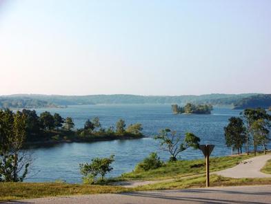
Visitors head to Damsite on Pomme de Terre Lake for days of enjoyable boating, fishing and swimming. Just as the name implies, Damsite Park is just above the dam, at the confluence of Lindley Creek and the Pomme de Terre River.

The lake is named for the river that feeds it. The phrase "Pomme de Terre" is French for potato or "apple of the earth." Most likely, the river was named by early French trappers and fur traders when they discovered plants resembling potatoes on the riverbanks.

Recreation

Excellent fishing is found at the lake, which boasts one of the best catch ratios in the country. Each fall the lake is stocked with muskie, but crappie, largemouth and white bass are also found in abundance.

Every year on Fourth of July holiday weekend, a fireworks display takes place over the dam.

Facilities

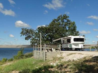
Damsite Park has 80 sites with electric hookups and 22 non-electric sites. Amenities include a dump station, two shower houses, two coin operated laundry machines, and a playground.

Natural Features

Pomme de Terre Lake sits in the rolling Ozark hills, with 7,790-acres of sparkling surface area and 113 miles of shoreline.

Nearby Attractions

One of the best dirt tracks in the country is right down the road or enjoy a round of golf at the nearby golf course. There are also multiple trails located around this part of the lake.

Reservation

More from CampingHiking.net:

RIDGE ROAD, Georgia Campground Images, Info & Reservations

Listen Directions From I-20 take Exit 183 (Appling). Go north on HWY 221 approximately 6 miles. At 4-way stop, go left (GA HWY 47) and drive approximately 5 miles. Campground road is on right. Follow signs. Phone 706-541-0282 Activities CAMPING, SWIMMING SITE Keywords RIDG,J STROM THURMOND LAKE Related Link(s) Rec

DENVER CABOOSE CABIN, Alaska Campground Images, Info & Reservations

Listen Directions The cabin is approximately 5.5 miles north of Skagway along the East Fork of the Skagway River. The cabin is beside the railroad tracks at the Denver Glacier Trailhead. Access is via the White Pass and Yukon Route Railroad from May 1 through September 30. Make reservations at

RED BLUFF CAMPGROUND, Missouri Campground Images, Info & Reservations

Listen Directions From St. Louis, Missouri, take I-44 west to Cuba. Continue on Highway 19 south to Cherryville. Take 49 south to Highway V, turn left to Davisville and travel approximately 1 mile and turn left into the campground. Phone 573-743-6042 Activities CAMPING, FISHING, WATER SPORTS Keywords REDB,MARK TWAIN NF

EAST LEMOLO CAMPGROUND, Oregon Campground Images, Info & Reservations

Listen Directions From Roseburg, OR, travel east on OR-138 / NE Diamond Lake Boulevard for approximately 72 miles, turn left onto Forest Road 2610 (Bird’s Point Road). Continue for 3 miles and turn right onto Forest Road 2614. Proceed 2 miles and turn left onto Forest Road 430. The campground

PLATTER FLATS, Texas Campground Images, Info & Reservations

Listen Directions From Colbert, Oklahoma, travel 5 miles north on US 75, turn west 5 miles to Platter Flats, OK, then follow signs to the campground. Physical address: 867 Trail Ride Road, Platter, OK 74753. Phone 580-434-5864 Activities CAMPING Keywords PLAT,TEXOMA LAKE,TEXOMA LAKE Related Link(s) Rec Area Info & Images