CROSS LAKE DAY USE, MN Campground Reservation, Info, Images, Map, Directions

CROSS LAKE DAY USE, Minnesota Campground Images, Info & Reservations

Directions

From Brainerd, Minnesota. on Highway 25; turn right on County Road 3 and travel north to Cross Lake, Minn. The Day Use area entrance is to the left, directly across from intersections 3 and 66.

Phone

651-290-5793

Activities

HISTORIC & CULTURAL SITE, FISHING, PICNICKING, VISITOR CENTER, DAY USE AREA, SWIMMING SITE, KAYAKING, CANOEING

Keywords

PRDA,PINE RIVER DAY USE,CROSS LAKE DAM DAY USE,MISSISSIPPI HEADWATER

Related Link(s)

Rec Area Info & Images

Minnesota State Road Conditions

Minnesota State Tourism

Overview

In Central Minnesota’s popular lakes area, the Cross Lake Day Use has tremendous appeal for families and friends, with an array of activities and facilities perfect for a day outdoors.

Recreation

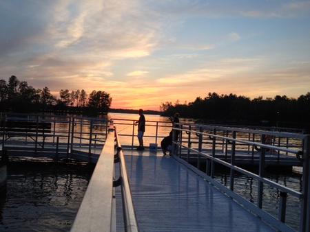
Swim or sunbathe at the beach, enjoy a meal at one of the numerous picnic sites, or for larger groups, reserve one of two group picnic shelters. Shore fishing is popular both upstream and downstream of the dam on accessible fishing piers, and canoe access is available for exploring the Pine River downstream of the dam.

Facilities

The area offers two group picnic shelters. The #1 shelter is located upstream of the dam and is smaller than the #2 shelter which is located downstream of the dam, along the Pine River. Canoe access is available along both shores of the Pine River downstream from the dam. A swimming beach and two accessible fishing piers are available within a short walk of the parking area. Other facilities include a playground, restrooms and parking facilities for up to 50 vehicles.

Natural Features

Surrounded by tall pines on the eastern bank of Cross Lake, the Day Use Area provides an ideal location to explore and enjoy the Whitefish Chain of Lakes, boasting 13,660 acres of water and 119 miles of scenic shoreline.

Nearby Attractions

The city of Crosslake is located within walking distance from the Day Use Area where you will find local shopping, a paved walking and biking trail and numerous other activities within town.

Reservation

More from CampingHiking.net:

WHITE CLIFFS PARK, Arkansas Campground Images, Info & Reservations

Directions Located six miles south of Cowlingsville on State Highway 317. Phone 870-287-4253 Activities BOATING, CAMPING, FISHING Keywords Related Link(s) Rec Area Info & Images Arkansas State Tourism Arkansas State Road Conditions Overview White Cliffs Campground is located on the east bank of the Little River feeding into Millwood Lake

PHOCENA BAY CABIN, Alaska Campground Images, Info & Reservations

Directions Approximately 15 air miles and 25 water miles from Ketchikan on the south shore of Phocena Bay on the west side of Gravina Island. Accessible by floatplane or by boat. A mooring buoy is located in Phocena Bay. Refer to USGS Ketchikan A-6. Please consult local tide tables before

LOST CREEK, Oregon Campground Images, Info & Reservations

Directions From Portland, follow Highway 26 for 18 miles past the town of Sandy to the community of Zigzag. Turn north (left) onto Lolo Pass Road (Forest Road 18). Travel just over 4 miles and turn right onto Forest Road 1825. Continue for less than a mile and then bear

CHERRY VALLEY, California Campground Images, Info & Reservations

Directions Campground can be reached from Hwy 120 using Cherry Lake Road also known as Forest Road (FR) 1N07 or from Cottonwood Road also known as FR 1N04.  -Traveling from Hwy 120, go East from Groveland 13.8 miles turn left on Cherry Lake Road/1N07 for 23.5 miles where it becomes

FISH CREEK (OR), Oregon Campground Images, Info & Reservations

Directions From Estacada, travel east on Highway 224 for approximately 16 miles. Phone 503-630-5721 Activities BIKING, BOATING, CAMPING, FISHING, HIKING, WATER SPORTS Keywords FLI1,MT. HOOD NF – FS Related Link(s) Rec Area Info & Images Oregon State Road Conditions Forest Service Concessionaire Oregon State Tourism Overview Fish Creek Campground is