WALLACE CREEK, MS Campground Reservation, Info, Images, Map, Directions

WALLACE CREEK, Mississippi Campground Images, Info & Reservations

Listen

Directions

From I-55, take exit 233 and head east on Country Road 36. After about 2.5 miles follow the signs to the campground.

Phone

662-563-4571

Activities

BOATING, CAMPING, FISHING, HIKING, SWIMMING SITE

Keywords

WALC,ENID LAKE – MS,LIPE’S BLUFF 43-72,PINEY WOODS 1-42,HICKORY RIDGE,MCCURDY POINT,WOODPILE 73-99,ENID LAKE

Related Link(s)

Rec Area Info & Images

Mississippi State Tourism

Mississippi State Road Conditions

Overview

Wallace Creek is a quiet, family-oriented campground situated along the banks of Enid Lake in the forests of northern Mississippi.

View a virtual tour of Enid Lake.

Recreation

Enid Lake has been recognized as one of America’s Top 10 Fishing Spots, with white crappie, bass and catfish available in abundance. The lake is the home of the world record white crappie, which weighed an impressive 5 pounds, 3 ounces. Fishing tournaments are held annually at the lake.

Hiking trails wind along the lakeshore and throughout the surrounding landscape, offering hiking, biking and horseback riding opportunities.

Boating is a popular pastime on the lake, and boat ramps are provided at the campground.

Facilities

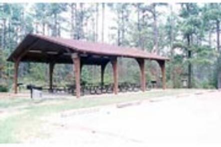
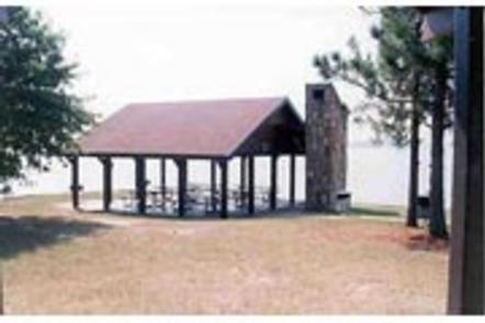
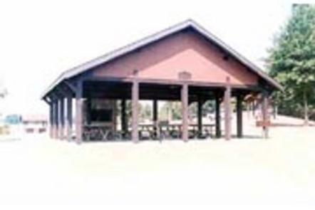
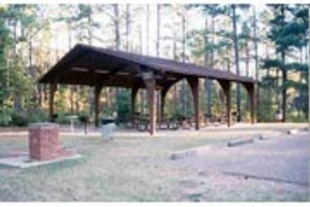
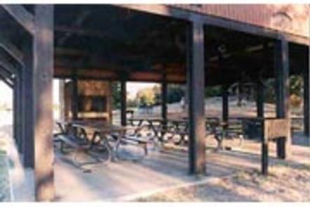
Wallace Creek Campground offers 101 campsites, along with four large group picnic shelters. Modern amenities like full hookups and flush toilets are provided, and a playground and interpretive trail offer additional recreation opportunities. Picnic areas complete with grills and picnic tables make the area perfect for parties or family trips.

Natural Features

Enid Lake is part of a dam project on the Yocona River. The dam creates almost 16,000 acres of water for the millions of annual visitors to enjoy. An additional 44,000 acres of thick, green forests surround the lake, offering countless recreational opportunities for campers, equestrians, hikers and more.

Nearby Attractions

Memphis, Tennessee, located about an hour away, offers plenty of famous tourist attractions.

Reservation

More from CampingHiking.net:

CAMP MISTY MOUNT, Maryland Campground Images, Info & Reservations

Listen Directions The street address for GPS use is 14764 Park Central Road, Thurmont, MD. From Washington DC, take the George Washington Memorial Parkway north to I-495 onto I-270 north 27 miles to Frederick, MD. Take Route 15 for 17 miles north to Thurmont, MD. Take Route 77 West, the

RIVERSIDE (KS), Kansas Campground Images, Info & Reservations

Listen Directions From Salina, KS: Take HWY 140 19 miles west to HWY 141. Travel 14 miles south on 141, then 1/2 mile east on Riverside Drive. Look for signs to the park. From Ellsworth, KS: Take HWY 140 15 miles east to HWY 141. Travel 14 miles South on

JOHNSON CREEK, Oklahoma Campground Images, Info & Reservations

Listen Directions From Durant, OK, travel 11 miles west on Highway 70. Exit off Highway 70 to the north and the park entrance is 300 yards ahead. Physical address: 215 Johnson Creek Road, Mead, OK 73449. Phone 580-924-7316 Activities CAMPING Keywords JOCR,TEXOMA LAKE,TEXOMA LAKE Related Link(s) Rec Area Info &

SPURT COVE CABIN, Alaska Campground Images, Info & Reservations

Listen Directions The cabin is accessible by boat or float plane only and the journey is about 18 miles by boat and 16 miles by plane from Petersburg. The cabin is accessible at any tide, but care should be taken when entering the cove at high tide because boats can

COUGAR ROCK GROUP CAMPGROUND, Washington Campground Images, Info & Reservations

Listen Directions Cougar Rock Campground is located 14 miles east of Ashford, Washington, on State Route 706/Paradise Road. Phone 360-569-2211 Activities CAMPING, INTERPRETIVE PROGRAMS, HIKING, PICNICKING, VISITOR CENTER, DAY USE AREA Keywords CG82,Mount Rainier National Park Related Link(s) Rec Area Info & Images Washington State Tourism Washington State Road Conditions