CHUTE GROUP, UT Campground Reservation, Info, Images, Map, Directions

CHUTE GROUP, Utah Campground Images, Info & Reservations

Listen

Directions

The campground is located about 26 miles west of Huntington, Utah, along Utah Highway 31.

Phone

435-384-2372

Activities

BIKING, CAMPING, FISHING, HIKING, HUNTING, WILDLIFE VIEWING

Keywords

CHUT,MANTI-LASAL NF -FS

Related Link(s)

Rec Area Info & Images

Utah State Tourism

Utah State Road Conditions

Overview

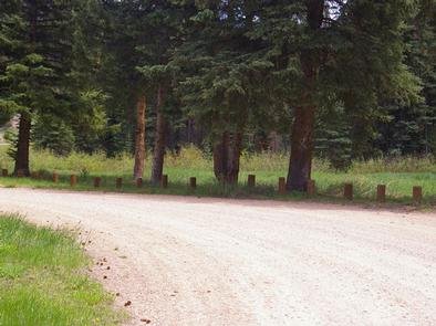
Chute Group Campground is located in beautiful Huntington Canyon, along the Huntington Canyon National Scenic Byway on Utah Highway 31. It is situated at an elevation of approximately 8,000 feet. Many recreational activities are available, including hiking, biking and fishing.

Recreation

Popular activities enjoyed by visitors to the area include fishing, hunting, hiking, mountain biking, horseback riding, rock climbing and scenic driving. Huntington Creek is a Blue Ribbon fishery, providing high quality fishing for brown, cutthroat and rainbow trout.

The 4-mile Left Fork of the Huntington National Recreation Trail is nearby and open to hikers and horseback riders. The 10-mile Fish Creek Trail, for hiking, biking and horseback riding is also close by.

Facilities

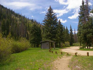
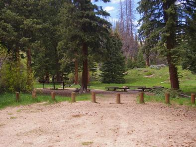
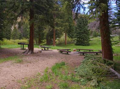
The campground offers one large-group campsite that can accommodate up to 50 people. An accessible vault toilet is provided, but there is no drinking water, electricity or garbage service. A large parking area within the campground is dirt. Grassy areas located throughout the site provide nice spots for tents.
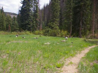
Natural Features

Large spruce trees offer shade throughout the site. Grassy meadows and thick stands of willow trees line Huntington Creek, which flows next to the campground. The canyon area has numerous lakes and streams, vibrant summer wildflowers, colorful fall foliage and abundant wildlife.

Nearby Attractions

The Huntington Canyon National Scenic Byway is part of the 86-mile Energy Loop. It offers stunning mountain and lake views as it tops 10,000 feet in elevation.

The historic Stuart Guard Station Visitor Center is nearby, offering a glimpse of the 1930s life of a ranger and his family who once lived there. Exhibits of Civilian Conservation Corps projects and original equipment are on display. Area information is available there as well.

Reservation

More from CampingHiking.net:

CHIPPEWA, Wisconsin Campground Images, Info & Reservations

Listen Directions From Medford, Wisconsin, travel north on State Highway 13 for 4 miles. Turn left onto County Road M and continue for about 24 miles then turn left onto Forest Road 1417. Phone 715-748-4875 Activities BOATING, CAMPING, FISHING, HIKING, SWIMMING SITE Keywords CHIP,MILLER DAM,MONDO DAM,CHEQUAMEGON-NICOLET NF – FS Related

POKEGAMA DAM CAMPGROUND, Minnesota Campground Images, Info & Reservations

Listen Directions From Grand Rapids, Minnesota, take Highway 2 west for 2 miles, turn left at signs and follow to campground. Phone 218-326-6128 Activities BIKING, BOATING, CAMPING, FISHING, VISITOR CENTER, DAY USE AREA, INFORMATION SITE, MOTOR BOAT, MOUNTAIN BIKING, KAYAKING, CANOEING, BERRY PICKING, BIRDING, CROSS COUNTRY SKIING, ANTIQUING Keywords POKE,GOVERNMENT

Laurel River Lake Picnic Area, Kentucky Campground Images, Info & Reservations

Listen Directions From London, Kentucky, head west on HWY 192 for approximately 15 miles. Turn slight left onto KY-1193. Continue on KY-1193 until arrive at destination on left. Area is marked by "Laurel Dam Picnic Area" signs. Phone 606-864-6412 Activities HIKING, SWIMMING SITE Keywords Laurel River Lake Picnic Area,Laurel Picnic

HILLTOP, Nevada Campground Images, Info & Reservations

Listen Directions From Las Vegas, travel north on Highway 95 to the junction with Highway 157/Kyle Canyon. Turn left and travel approximately 17 miles to the junction with Highway 158/Deer Creek. Turn right and travel about 4 miles to the campground on the right side of the road. Phone 702-872-5486

SPRUCES CAMPGROUND (DIXIE NF), Utah Campground Images, Info & Reservations

Listen Directions Go east from Cedar City on Scenic Byway SR 14, 25 miles to the Navajo Lake road turnoff to the south. Follow the Navajo Lake road 7 miles to Spruces campground. Phone 801-226-3564 Activities BIKING, BOATING, CAMPING, FISHING, HIKING, WILDLIFE VIEWING, PHOTOGRAPHY, MOUNTAIN BIKING, KAYAKING, CANOEING, WATER ACCESS,