BLUFFVIEW PARK, TX Campground Reservation, Info, Images, Map, Directions

BLUFFVIEW PARK, Texas Campground Images, Info & Reservations

Listen

Directions

From Woodville, Texas, go 11 miles east on U.S. 190. Turn south on FM 92 and go 5 miles to the park, which is on the left just north of the project office.

Phone

1 (877) 444-6777

Activities

CAMPING, FISHING, WILDLIFE VIEWING

Keywords

BFVP,TOWN BLUFF DAM,OVERLOOK PARK,DAM B,TOWN BLUFF DAM

Related Link(s)

Rec Area Info & Images

Texas State Road Conditions

Texas State Tourism

Overview

Bluffview Park is located on the southwest side of B.A. Steinhagen Lake, in Town Bluff, Texas. The lake provides a great getaway for fishing, boating, picnicking, camping and birding.

Recreation

B.A. Steinhagen Lake is a prime location for boating, canoeing, fishing and wildlife viewing. Several parks with boat ramps and docks are scattered around the lake.

Fishing is a popular pastime. Largemouth bass, catfish and crappie are the primary sport species found in the lake.

Younger anglers love the children’s fishing pond within Magnolia Park, just 6.5 miles north. A Kid’s Fish Day is held annually in June.

The road systems within nearby Magnolia Ridge and Sandy Creek Parks offer excellent family biking opportunities for 3-5 mile rides.

Facilities

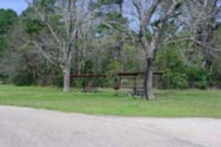
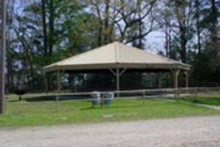
Bluffview Park is a year-round day-use area that offers one large group picnic shelter with electricity and water. Numerous individual picnic sites, some of which have shelters, are available on a first come, first served basis. Flush toilets, drinking water and trash collection are provided.

A small store is located across the road from the campground with bait, fuel and ice.

Natural Features

The lake lies in the heart of the East Texas Pineywoods, a beautiful region known for its pine uplands, bottomland hardwoods and pine-hardwood mixed forests, which provide habitat for a wide range of wildlife.

White-tailed deer, squirrels, rabbits, red and gray fox, bobwhite quail, and numerous species of ducks, geese, waterfowl and songbirds make their home in the area.

Nearby Attractions

Nearby Martin Dies, Jr. State Park offers hiking, canoeing, fishing, swimming, biking and wildlife viewing opportunities. The Walnut Slough, Sandy Creek and Neches Paddling Trails meander from 3-16 miles on the park’s backwater sloughs, the open lake and the swift Neches River.

The Angelina-Neches/Dam B Wildlife Management Area is located at the north end of the lake, covering nearly 13,000 acres. The area boasts beautiful mature hardwoods, including cypress, sweet gum and red and water oak. Some areas feature stands of loblolly and shortleaf pine. Visitors have the opportunity to hunt, fish, hike and view wildlife in this extraordinary ecosystem.

Reservation

More from CampingHiking.net:

Sand Island Group Sites, Utah Campground Images, Info & Reservations

Listen Directions Sand Island Campground is located on the north bank of the San Juan River about 3 miles west of Bluff, Utah, on the south side of Highway 191. Phone 435-587-1500 Activities HISTORIC & CULTURAL SITE, CAMPING, PICNICKING, PHOTOGRAPHY, PADDLING, WATER ACCESS, WHITEWATER RAFTING Keywords None Related Link(s) Rec

PAYSON LAKES, Utah Campground Images, Info & Reservations

Listen Directions From I-15, take exit 250 toward north Payson/Salem and proceed south on Main Street to 100 North/Highway 198. Travel east to 600 East. Turn south onto 600 east, which becomes the Nebo Loop Scenic Byway/Payson Canyon Road. Travel up the canyon to the campground. Phone SPANISH FORK RANGER

NORTH SHORE PICNIC AREA, Idaho Campground Images, Info & Reservations

Listen Directions From Stanley, Idaho, take State Highway 75 south for 4 miles. Turn west onto Forest Road 214 at the Redfish Lake sign and travel approximately 2 miles. Turn right at the North Shore Picnic Area entrance sign. Phone 928-537-8888 Activities BIKING, BOATING, CAMPING, FISHING, HIKING, HORSEBACK RIDING, WATER

DEARHAMER CAMPGROUND, Colorado Campground Images, Info & Reservations

Listen Directions From Basalt, travel east on Frying Pan River Road for approximately 20 miles, just past Ruedi Reservoir to Dearhamer Campground. Phone 970-927-0107 Activities BIKING, CAMPING, INTERPRETIVE PROGRAMS, HIKING, WATER SPORTS, WILDLIFE VIEWING Keywords Related Link(s) Rec Area Info & Images Forest Service Concessionaire Colorado State Road Conditions Colorado

WILLIS CREEK, Texas Campground Images, Info & Reservations

Listen Directions From Interstate 35, take Highway 95. Go north on Highway 95 to County Road 346. Turn right on County Route 346 and go 4 miles to the park entrance. Follow signs. Phone 512-859-2668 Activities CAMPING, FISHING, HORSEBACK RIDING, WATER SPORTS, SWIMMING SITE Keywords WILC,GRANGER LAKE,LAKE GRANGER,GRANGER LAKE Related

Miller River Group Camp, Washington Campground Images, Info & Reservations

Listen Directions From I-5 north, take exit 194 to Highway 2. Continue for about 48 miles, then turn south at the Money Creek Campground sign. Continue about 3 miles to the campground. Phone 360-804-1103 Activities BIKING, CAMPING, FISHING, HIKING, WILDLIFE VIEWING Keywords MILR,MT. BAKER-SNOQU NF – FS Related Link(s) Rec