BLACKBERRY, OR Campground Reservation, Info, Images, Map, Directions

BLACKBERRY, Oregon Campground Images, Info & Reservations

Listen

Directions

From Waldport, Oregon, take State Route 34 east about 18 miles and turn right at the sign for the campground.

Phone

541-528-7424

Activities

BIKING, BOATING, CAMPING, FISHING, HIKING, CANOEING, BERRY PICKING, CRAWFISHING

Keywords

BLBE,SIUSLAW NF – FS

Related Link(s)

Rec Area Info & Images

Oregon State Road Conditions

Oregon State Tourism

Forest Service Concessionaire

Overview

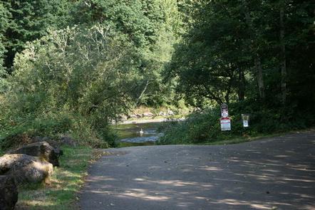
Blackberry Campground is perched on a heavily wooded bluff overlooking the Alsea River. The well-maintained campground offers plenty of fishing opportunities, including crawfishing. Swimming in the Alsea River is a popular summer activity.

Recreation

The Alsea River is a favorite spot for drift boating, and a boat ramp is located on-site. Anglers cast by boat or from shore for Coho and Chinook salmon and Steelhead trout. Crawfishing is also a popular activity. The shellfish can often be found along the riverbank.

The area is known for elk hunting, and the campground makes a great base camp for hunting parties.

Facilities

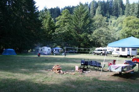
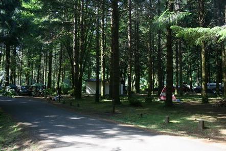
Some sites overlook the river and others are situated beside a large, manicured grassy field. Parking spurs are paved and each site is equipped with a campfire ring and picnic table.

No dump station or electric hookups are available. The nearest dump station is in Waldport.

Natural Features

Blackberry Campground sits among tall cedars and Douglas fir in the Siuslaw National Forest, where blackberry bushes are scattered on the forest floor. The Siuslaw encompasses over 630,000 acres and stretches from the lush forests of the coastal mountains to the Oregon Dunes and beaches of the Pacific Ocean.

The Alsea River flows 48.5 miles from the town of Alsea out to the Pacific Coast at Waldport and Alsea Bay.

Nearby Attractions

Sandy beaches stretch north and south of Waldport, just 20 minutes from the campground. Beautiful Cape Perpetua Scenic Area is another 15 minutes south of Waldport. Mary’s Peak is the highest point in Oregon’s Coast Range and has been designated a Scenic Botanical Area because of its rich, unique scenery and plants.

Reservation

More from CampingHiking.net:

Whispering Pines Horse Camp, Oregon Campground Images, Info & Reservations

Listen Directions From Sisters, OR:Travel approximately 6 miles west on Highway 242 (McKenzie Pass Highway) then follow the signs into Whispering Pine Horse Camp. Phone 541-323-1746 Activities CAMPING Keywords Related Link(s) Rec Area Info & Images Oregon State Road Conditions Oregon State Tourism Overview Located eleven miles west of Sisters,

CABIN CREEK CABIN, Montana Campground Images, Info & Reservations

Listen Directions Summer access from West Yellowstone: Take U.S. Highway 287 to Forest Service Road 681, Red Canyon Rd, then to the Red Canyon Trailhead. Foloow Trail #205 approximatley 5 miles to Cabin Creek Trail, then 1 mile via hike, horse, mountain bike, or motorcylce to the cabin. Note: ATVs

FRENCH CAMP, California Campground Images, Info & Reservations

Listen Directions From Bishop or Mammoth Lakes, California, follow U.S. Highway 395 (about 30 miles north of Bishop). Take the Tom’s Place exit and go 1 mile on Rock Creek Road. Phone 760-935-4825 Activities CAMPING, FISHING, HIKING, HUNTING, PICNICKING, WILDLIFE VIEWING Keywords FREN,INYO NF – FS Related Link(s) Rec Area

GRANITE FLAT (CALIFORNIA), California Campground Images, Info & Reservations

Listen Directions From Truckee, take Highway 89 south approx. 1 mile to the campground. Phone (530)587-3558. FOR RESERVATIONS, PLEASE CALL: 1 (877) 444-6777. Activities BIKING, CAMPING, FISHING, HIKING, WATER SPORTS, SWIMMING, MOUNTAIN BIKING Keywords GRFL,GRANITE FLAT CALIFORNIA,TAHOE NF – FS Related Link(s) Rec Area Info & Images California State Tourism

SAN JUAN BAY CABIN, Alaska Campground Images, Info & Reservations

Listen Directions The cabin is 90 miles southwest of Cordova in San Juan Bay on the southwest end of Montague Island. Access to the cabin is by wheel plane at low tide only (60 minutes from Cordova, 40 minutes from Seward). Click here for local tide tables. Phone 1 (907)

LONE BRANCH, Tennessee Campground Images, Info & Reservations

Listen Directions From Nashville, TN, take I-40 East to exit 229-B/Golden Bear Gateway. Continue straight on Golden Bear Gateway for approximately 9 miles. Entrance to the recreation area will be on your left just passed Cedar Creek Club. * Golden Bear Gateway turns into Benders Ferry Road at the US-70/Lebanon