MALAD SUMMIT CAMPGROUND, ID Campground Reservation, Info, Images, Map, Directions

MALAD SUMMIT CAMPGROUND, Idaho Campground Images, Info & Reservations

Directions

From Malad, travel north on Interstate 15 for 11 miles, to exit 22, Devil Creek Reservoir. Continue just over 3 miles north on Highway 191. Turn west and cross the highway on Forest Road 041 and continue just over 3 miles on a maintained gravel road, to the campground.

Phone

208-236-7500

Activities

BIKING, CAMPING, FISHING, HIKING, WILDLIFE VIEWING

Keywords

MASU,SUMMIT CAMPGROUND,POWER HOUSE CAMPGROUND,CARIBOU-TARGHEE NF – FS

Related Link(s)

Rec Area Info & Images

Idaho State Tourism

Idaho State Road Conditions

Overview

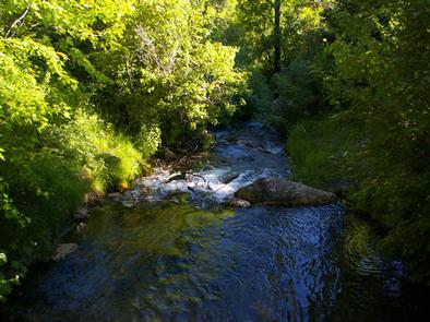
Malad Summit Campground is situated next to Mill Creek, just 14 miles north of Malad, Idaho, at an elevation of 6,100 feet. Visitors enjoy hiking, horseback riding and off-road vehicle riding on the area’s many trails.

Recreation

Mill Creek offers cutthroat and rainbow trout fishing. Numerous trails begin nearby, including the 12-mile multi-use Summit Trail, which connects with Farmers Canyon, East Elkhorn and Wright Creek trails. Old Canyon and South Canyon trails begin a short distance from the campground.

Facilities

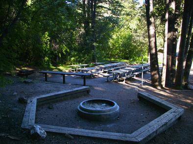
The campground is open year-round and contains one large group site that can accommodate up to 125 people. It is equipped with large picnic tables, a serving table, a grill, a campfire ring with benches, tent pads and a gravel parking area.

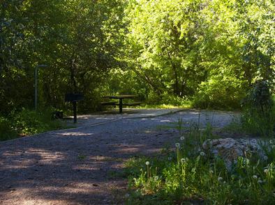
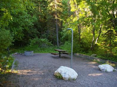
Single-family campsites are also available within the campground. Each is equipped with a table, campfire ring and grill.

Vault toilets and drinking water are provided. Roads and parking spurs within the campground are gravel. Security is provided by the host and periodic patrols by the county sheriff.

Natural Features

The campground is settled in a dense forest of maple trees, which offer plentiful shade. Stately Douglas fir trees dot the landscape. The campground receives snow throughout the winter.

Reservation

More from CampingHiking.net:

PRUNE CREEK, Wyoming Campground Images, Info & Reservations

Directions Located 26 miles southwest of Dayton, Wyoming along U.S. Highway 14. Phone 406-587-9054 Activities BIKING, BOATING, FISHING, HIKING, VISITOR CENTER, WILDLIFE VIEWING, HOTEL/LODGE/RESORT PRIVATELY OWNED, OFF ROAD VEHICLE TRAILS Keywords PRUN,BIGHORN NF – FS Related Link(s) Rec Area Info & Images Overview Prune Creek Campground is located along the

COTTONWOOD CAMPGROUND (CA), California Campground Images, Info & Reservations

Directions The park headquarters address is not the physical address of the campground. To get to the campground, take Interstate 10 to the I-10 exit 168 Mecca/Twentynine Palms exit and follow signs to Joshua Tree National Park. The exit is 25 miles east of Indio, California. Phone 760-367-5554 Activities CAMPING,

INDIAN FLATS CABIN, Montana Campground Images, Info & Reservations

Directions Indian Flats Cabin is located 40 miles northeast of Helena. Take Highway 280 east from Helena. Several miles after crossing the Missouri River, you will come to the small community of York. Turn left at the York Bar and proceed 5 miles to the smaller community of Nelson, where

INDIAN HOLLOW, Massachusetts Campground Images, Info & Reservations

Directions Driving directions to the campground: Address: 200 Indian Hollow Rd, Chesterfield, MA 01012 From intersection of State Route 143 and South Street in the center of Chesterfield, turn south on South Street. Follow for approx. 2 miles and turn right onto Indian Hollow Road. Follow Indian Hollow Road to