
Directions
From Highway 89 approximately 7 miles south of Panguitch, Utah, travel east on Highway 12 for about 14 miles. Turn south on Highway 63 to the main entrance of Bryce Canyon National Park. Sunset Campground is on the west (right) side of the road approximately 1.5 miles past the Visitor Center.
Phone
435-834-5322
Activities
CAMPING, INTERPRETIVE PROGRAMS, HIKING, HORSEBACK RIDING, WINTER SPORTS, VISITOR CENTER, WILDLIFE VIEWING, OTHER RECREATION CONCESSION SITE
Keywords
SUCA,SUNSET CAMPGROUND BRYCE CANYON,BRYCE CANYON NATIONAL PARK
Related Link(s)
Overview
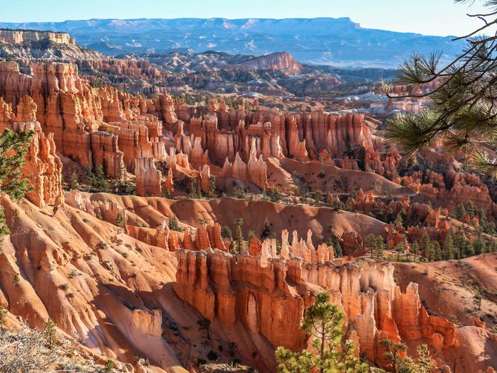
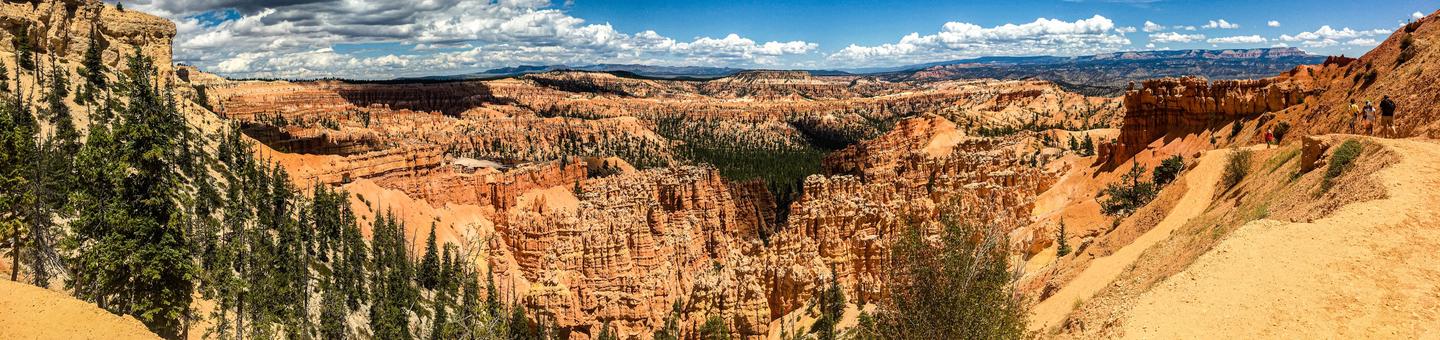
Sunset Campground is located in beautiful and unique Bryce Canyon National Park. Known for its colorful rock spires and grand vistas that sweep out over the High Plateaus region of the Colorado Plateau, Bryce Canyon is the ultimate camping destination.
Situated at an elevation of about 8,000 feet, the campground is located 1.5 miles from the park’s Visitor Center. Famed Sunrise and Sunset Points are nearby at the heart of the magnificent geologic wonder of Bryce Amphitheater, where hiking and photography opportunities are plentiful.
Recreation
Bryce Canyon offers several day-hiking trails, many of which are inter-connected. Single trails range from easy to strenuous, and from less than a mile in length up to 11 miles. The most popular hikes are combinations of two or three trails.
Bryce Amphitheater has spectacular rock formations and sweeping views, providing excellent photography opportunities. The Bryce Canyon Shuttle, which runs from May to September, makes several stops throughout the park, giving visitors easy access to its most popular trailheads and viewpoints.
Astronomers love visiting Bryce Canyon, where 7,500 stars are visible on a moonless night. An annual Astronomy Festival is held in June, and astronomy and stargazing programs are offered more than 100 nights throughout the year. Guided full moon hikes are also a fun way to experience the park at night.
Facilities
Sunset Campground is a very popular site with gravel parking spurs, flush toilets and drinking water. Picnic tables and fire rings with grills are also provided. During the summer months, laundry and shower facilities are available at the general store nearby. The Bryce Canyon Shuttle makes a stop at the campground’s entrance. This site is the closest in the park to many popular hiking trails, which begin and end at Sunset Point.
Natural Features
A ponderosa pine forest towers over Sunset Campground, offering equal parts sun and shade. The site is situated in a gently rolling landscape dotted with shrubs and summer wildflowers.
Nearby Attractions
The Colorado Plateau contains a multitude of awe-inspiring landscapes and Bryce Canyon lies very close to many of them, including Red Canyon, Kodachrome Basin State Park, Cedar Breaks National Monument, Grand Staircase-Escalante National Monument, Panguitch Lake, Boulder Mountain, Calf Creek Recreation Area, Capitol Reef National Park, Zion National Park and Grand Canyon National Park. Driving along Scenic Byway 12 is a must-do for its red rock canyons and jaw-dropping views.