CARP RIVER CAMPGROUND, MI Campground Reservation, Info, Images, Map, Directions

CARP RIVER CAMPGROUND, Michigan Campground Images, Info & Reservations

Listen

Directions

4664 Mackinac Trail, St Ignace Michigan 49781

From the intersection of US-2 and I-75, drive north on I-75 to exit 352. Turn right on County Road 123, then turn left on Mackinac Trail/Highway 63. Drive north approximately five miles, turn left onto FR 3445 and drive a quarter mile to the campground.

Phone

906-203-9872

Activities

BIKING, CAMPING, FISHING, HIKING, WILDLIFE VIEWING

Keywords

CARP,HIAWATHA NF – FS

Related Link(s)

Rec Area Info & Images

Michigan State Tourism

Michigan State Road Conditions

Overview

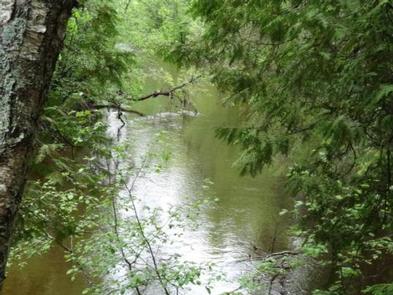
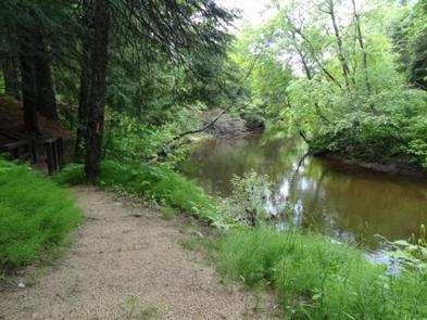
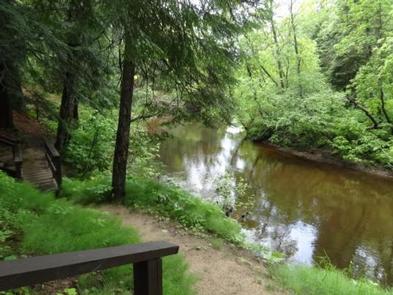
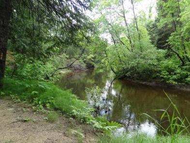
Nestled in a quiet, rustic setting adjacent to the Carp Wild and Scenic River, Carp River Campground is an ideal place to get away and enjoy the outdoors.

The surrounding Hiawatha National Forest provides visitors with countless recreational activities, and the scenery provides a beautiful backdrop for a traditional camping experience.

Recreation

Divided into two major blocks of land and five districts, the forest is home to Grand Island National Recreation Area, Whitefish Scenic Byway, six lighthouses, five Wildernesses and Clear Lake Education Center. In addition to recreation opportunities, visitors will find a wide array of habitats, including trees like northern hardwoods, jackpine and other conifers, and a variety of inland wetland habitats.

Fishing is a popular activity in the campground area, and brook, brown and rainbow trout can all be spotted in the Carp River.

In addition to the fishing opportunities, hiking canoeing, kayaking, wildlife viewing and more are all available at or around the Carp River Campground.

Facilities

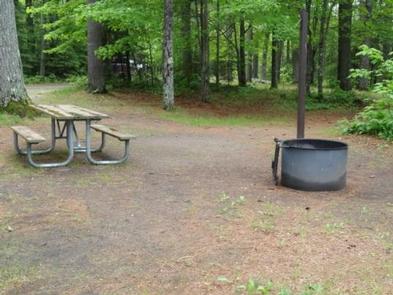
All campsites are wooded and shaded from the hot summer sun. Each site has a table and a fire ring, and drinking water and vault toilets are conveniently spaced throughout the campground.

Natural Features

Located in Michigan’s wild and scenic Upper Peninsula, the Hiawatha National Forest is known as "the Great Lakes National Forest." The forest’s dramatic shorelines lie nestled up to Lakes Superior, Huron and Michigan.

Outstanding lakeshores, lighthouses, islands and historic sites create a playground and place of respite, all within a day’s drive from major urban and rural areas of Michigan and Wisconsin.

Nearby Attractions

Carp River Campground is located just eight miles from St. Ignace, which is known for its fine restaurants, museums and historic sites.

Charges & Cancellations

Please cancel seven days in advance if you need to cancel your reservation. Reservation sites cannot be traded for walk up sites.

Reservation

More from CampingHiking.net:

PARKSIDE, Montana Campground Images, Info & Reservations

Listen Directions From U.S. Highway 212, turn off at Rock Creek Road (Forest Road 2421). Go 0.3 miles to the campground entrance on the right. Phone 406-587-9054 Activities BIKING, BOATING, CAMPING, FISHING, HIKING Keywords PKSD,CUSTER NF – FS Related Link(s) Rec Area Info & Images Overview Parkside Campground is located

MAIN DAY USE, Wisconsin Campground Images, Info & Reservations

Listen Directions From Minneapolis/St. Paul, take I-94 east to Exit 24. Take County Road B south approximately 6 miles and follow the highway signs to the park. Phone 715-778-5562 Activities BIKING, BOATING, FISHING, HIKING, PICNICKING, VISITOR CENTER, WILDLIFE VIEWING, SWIMMING SITE, PHOTOGRAPHY, SWIMMING, KAYAKING, CANOEING, STAR GAZING, BIRDING, NON-MOTORIZED BOATING,

ELLA NARROWS CABIN, Alaska Campground Images, Info & Reservations

Listen Directions The cabin is approximately 24 air miles northeast of Ketchikan on Revillagigedo Island on the north end of Ella Lake. Access is by floatplane or boat. Refer to USGS Ketchikan C-4 and B-4. In fall, winter and early spring, the cabin may be inaccessible due to frozen lake

Anthony Lake, Oregon Campground Images, Info & Reservations

Listen Directions From Baker City, head north on Highway 30 toward Haines, approximately 10 miles. In Haines, turn left and follow the Anthony Lake Highway signs (turns into Forest Road 73) for 25 miles to the Anthony Lake Recreation Area. Turn left into the Anthony Lake Campground. The main campground

TURKEY CREEK, Oklahoma Campground Images, Info & Reservations

Listen Directions From Broken Bow, OK, travel Highway 3 west for 28 miles to the entrance sign. Follow access road north 5 miles to the campground. Phone 580-876-3720 Activities BOATING, CAMPING, FISHING Keywords TURK,PINE CREEK LAKE,PINE CREEK LAKE Related Link(s) Rec Area Info & Images Oklahoma State Road Conditions Oklahoma

TOWNSHEND LAKE DAY USE AREA, Vermont Campground Images, Info & Reservations

Listen Directions Townshend Lake is located 19 miles north of Brattleboro, Vermont, on Vermont Route 30. Phone 802-365-7703 Activities BIKING, BOATING, CAMPING, FISHING, HIKING, WINTER SPORTS, WILDLIFE VIEWING, SWIMMING SITE, SWIMMING, SNOWMOBILE, KAYAKING, CANOEING, BIRDING, CROSS COUNTRY SKIING, RAFTING, WHITEWATER RAFTING, SNOWSHOEING, SLEDDING, SNOWMOBILE TRAILS Keywords Townshend Dam Related Link(s)