TENDERFOOT CREEK, AK Campground Reservation, Info, Images, Map, Directions

TENDERFOOT CREEK, Alaska Campground Images, Info & Reservations

Directions

From Anchorage, go south on Seward Highway approximately 81 miles to Summit Lake. Turn at milepost 46 before Summit Lake Lodge.

Phone

(907)288-3178

Activities

BIKING, BOATING, CAMPING, FISHING, HIKING

Keywords

TEND,CHUGACH NF – FS

Related Link(s)

Rec Area Info & Images

Forest Service Concessionaire

Alaska State Tourism

Alaska State Road Conditions

Overview

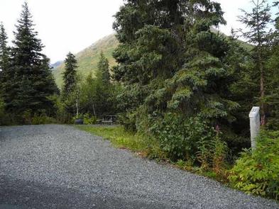
Tenderfoot Creek Campground unveils views of the surrounding mountains from every direction and offers campsites that face the edge of a glistening lake.

Perched along Summit Lake on the Eastern Kenai Peninsula of Alaska, Tenderfoot Creek provides an ideal destination for fishing, kayaking, canoeing, hiking and wildlife watching.

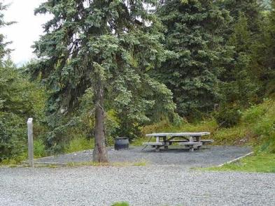
Campers may experience morning wakeup calls from loons or view bald eagles fishing in the clear waters. Impressive wildlife inhabitants include moose, brown and black bears, mountain goats, lynx and wolves. Campsites are nicely spaced along the eastern shores of Summit Lake. Tenderfoot Creek passes through the campground and surrounding forest includes spruce and hemlock.

Recreation

The Summit Lake Trail heads south of Summit Lake and connects with the Resurrection Pass Trail, a wonderful 39-mile hiking and biking trail that climbs 2,100 feet of elevation, providing excellent views of the area. The lake is stocked with Dolly Varden and Rainbow trout.

Winter recreation includes backcountry skiing, snow-boarding and snowshoeing.

Facilities

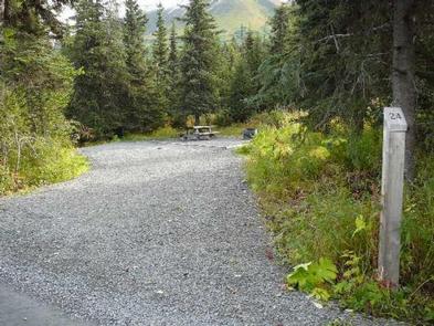
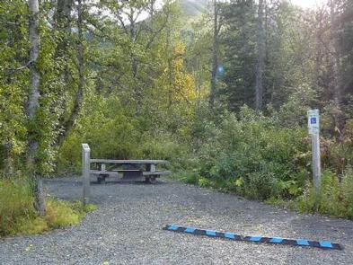
Tenderfoot Creek campers enjoy amenities such as drinking water, vault toilets, picnic tables, trash collection, fire pits and a boat ramp. The majority of campsites are pull-through and parking aprons are gravel. Firewood can be purchased onsite.

Natural Features

Summit Lake is a small cirque lake, or tarn, reaching a depth of 20 feet. This cirque was the beginning of a long-gone, alpine glacier. The surrounding terrain and unique mountain landscape is all glacially carved.

Nearby Attractions

Visit Portage Glacier in the Portage Valley, a 14-mile isthmus that connects the Kenai Peninsula to mainland Alaska. Glacial remnants that can be seen today are Explorer, Middle, Byron, Burns and Shakespeare glaciers.

Reservation

More from CampingHiking.net:

SHADY COVE GROUP CAMPGROUND, California Campground Images, Info & Reservations

Directions From Running Springs, drive approximately one mile on Highway 18 to the Deerlick Ranger Station/Children’s National Forest Visitor Center. Turn right on Keller Peak Road and continue about five miles. Follow signs to the campground. Phone 909-866-8550 Activities BIKING, CAMPING, INTERPRETIVE PROGRAMS, FISHING, HIKING, WILDLIFE VIEWING Keywords SHAC,Shady Cove,Children’s

DOLLY COPP, New Hampshire Campground Images, Info & Reservations

Directions From Gorham, New Hampshire: Take State Route 16 south for 6 miles. Turn right onto Dolly Copp Road and travel 0.5 miles to the campground. From North Conway, New Hampshire: Take Highway 302 to Glen. Turn right onto State Route 16 north and follow for about 22 miles. Turn

POCKET PICNIC SHELTER, Georgia Campground Images, Info & Reservations

Directions From I-75, take Exit 320 (LaFayette/Resaca) and head west on Georgia State Route 136 for approximately 14 miles. Turn left onto Pocket Road and continue approximately 7 miles. The recreation area is on the left. The second driveway leads to the picnic shelter. Phone 706-695-6736 Activities HISTORIC & CULTURAL

Denny Creek Campground, Washington Campground Images, Info & Reservations

Directions From Seattle, take Interstate 90 east to exit 47. Go north over the freeway and follow signs 3 miles to campground. Phone 360-804-1103 Activities CAMPING, FISHING, HIKING Keywords DENN,MT. BAKER-SNOQU NF – FS Related Link(s) Rec Area Info & Images Washington State Road Conditions Washington State Tourism Forest Service

MANISTIQUE – RAPID RIVER DISPERSED CAMPSITES, Michigan Campground Images, Info & Reservations

Directions All driving directions are listed by lake. Please check campsite details. Phone 906-474-6442 Activities BIKING, BOATING, CAMPING, FISHING, HIKING, HORSEBACK RIDING, WATER SPORTS, WILDLIFE VIEWING, DAY USE AREA, SWIMMING SITE Keywords Dispersed campsites,Manistique,Rapid River,lyman lake,swan lake,bass lake,bear lake,camp cook,carr lake,chicago lake,clear lake,crooked lake,east lake,gooseneck lake,ironjaw lake,jackpine lake,lake nineteen,leg lake,little

LOST RAPIDS, Oklahoma Campground Images, Info & Reservations

Directions From Broken Bow, OK, take Highway 3 west 22 miles to the park entrance. Turn south at the sign and follow the access road. Phone 580-876-3720 Activities BOATING, CAMPING, FISHING, PICNICKING, CANOEING Keywords LOSR,PINE CREEK LAKE,PINE CREEK LAKE Related Link(s) Rec Area Info & Images Oklahoma State Tourism Oklahoma