POWERHOUSE GROUP PICNIC AREA, NV Campground Reservation, Info, Images, Map, Directions

POWERHOUSE GROUP PICNIC AREA, Nevada Campground Images, Info & Reservations

Listen

Directions

Take Interstate 80 to any Elko exit. Head south on Idaho Street, then turn south on 12th Street (from the east) or 5th Street (from the west), to State Route 227. Travel 25 miles on State Route 227 to Forest Road 660 (Lamoille Canyon Scenic Byway). Travel a short distance on Forest Route 660 to the picnic area.

Phone

775-752-3357

Activities

BIKING, CLIMBING, CAMPING, FISHING, WILDLIFE VIEWING

Keywords

PGPA,HUMBOLDT-TOIYABE NF-FS

Related Link(s)

Rec Area Info & Images

Forest Service Concessionaire

Nevada State Road Conditions

Nevada State Tourism

Overview

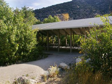
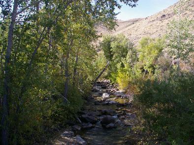
Powerhouse Group Picnic Area is set in scenic Lamoille Canyon, next to Lamoille Creek, at an elevation of 6,500 feet. Elko, in northeastern Nevada, is just 25 miles away. Visitors enjoy fishing and exploring local trails.

Recreation

Fishing for rainbow and brook trout is popular on the creek. Lamoille Canyon contains numerous hiking and horseback riding trails that lead to alpine lakes and scenic vistas. The canyon road itself is popular for scenic driving and road biking. Many rock-climbing routes can be found on the canyon walls.

Facilities

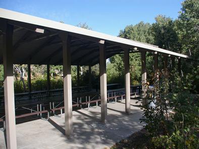
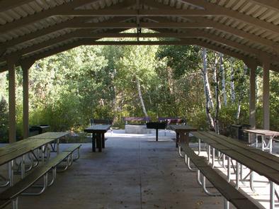
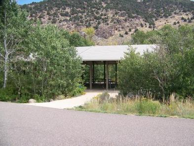
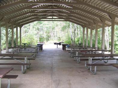
This day-use picnic area was constructed in 2003 and is a fully accessible site. A large shelter covers several picnic and serving tables, two grills and a campfire circle with benches. Accessible vault toilets and trash collection are provided but drinking water is not available. A large parking area is adjacent to the site, accommodating 25 through 30 vehicles.

Natural Features

The picnic area is situated at the mouth of Lamoille Canyon, a part of the beautiful Ruby Mountains. The area is a desert island brimming with wildlife, sparkling lakes and streams, wildflower-filled meadows and jagged peaks.

The shelter is surrounded by a stand of shady aspens. Lamoille Creek runs through the site.

Reservation

More from CampingHiking.net:

TWIN CREEKS PICNIC PAVILION, Tennessee Campground Images, Info & Reservations

Listen Directions From downtown Gatlinburg Tennessee, Turn south at stoplight #8 in Gatlinburg. Follow Historic Nature Trail Road to 4-way junction at access road to Park Vista Hotel. Go straight and continue 1.4 miles into the Park. turn right at Twin Creeks sign. Phone 865-436-1261 Activities CAMPING, FISHING, HIKING, WILDLIFE

BUSHYTAIL, California Campground Images, Info & Reservations

Listen Directions From I-5, take 299 west to Weaverville. Then take State Highway 3 north for 16 miles. Turn right at Minersville/Bushytail, then turn left into campground. Phone 530-275-8113 Activities BOATING, CAMPING, FISHING, HIKING, WATER SPORTS, SWIMMING SITE Keywords BUSH,SHASTA-TRINITY -FS Related Link(s) Rec Area Info & Images Forest Service

KELSEY CAMPGROUND, Colorado Campground Images, Info & Reservations

Listen Directions From Denver, take Highway 285 southwest to Pine Junction and turn south on Jefferson County Road 126. Travel approximately 17 miles to the campground. Phone 303-275-5610 Activities BIKING, CLIMBING, CAMPING, HIKING, WILDLIFE VIEWING Keywords KELS,PIKE AND SAN ISABEL NF- FS Related Link(s) Rec Area Info & Images Colorado

ELROD FERRY, Georgia Campground Images, Info & Reservations

Listen Directions From Hartwell, GA, travel approximately 2.5 miles on Highway 29 North. Turn left onto Elrod Ferry Road, and after a mile follow the brown directional signs to the facility. 1387 ELROD FERRY ROAD, Hartwell GA 30643 Phone 888-893-0678 HARTWELL PROJECT OFFICE Activities BOATING, FISHING, PICNICKING, DAY USE AREA,