
Directions
From Butte Falls, OR, drive east on the Butte Falls – Fish Lake Highway (County Road 821). Less than a mile from town, turn left onto the Butte Fall – Prospect Highway (County Road 992) and travel north on County Road 992. Go 9 miles on County Road 992 to Forest Road 34. Turn right, go 8 miles on Forest Road 34 until its junction with Forest Road 37. Travel north / northeast on Forest Road 37 for 4.5 miles. Take Imnaha Campground turn-off and continue through campground to find the cabin. From Prospect, OR, at the Prospect Hotel turn east onto the Butte Falls – Prospect Highway (County Road 992), travel 2 or 3 miles and take a left onto Forest Road 37, which continues south to Imnaha Campground turn-off. Wheeled-vehicle access is possible only from late spring through early fall, depending on snow conditions.
Phone
541-865-2700
Activities
CAMPING, HIKING, WILDLIFE VIEWING
Keywords
IMNA,SISKIYOU,ROGUE RIVER,ROGUE RIVER NATIONAL FOREST,SISKIYOU NATIONAL FOREST,ROGUE RIVER-SISKIYOU NATIONAL,ROGUE RIVER SISKIYOU NATIONAL,ROGUE RIVER-SISKIYOU,ROGUE RIVER SISKIYOU,ROGUE RIVER – SISKIYOU NF – FS
Related Link(s)
Overview
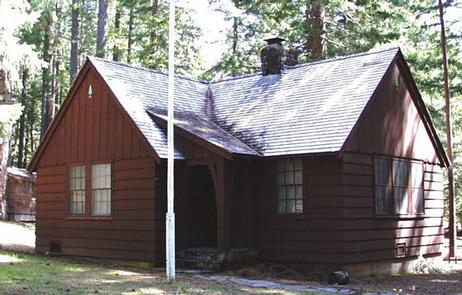
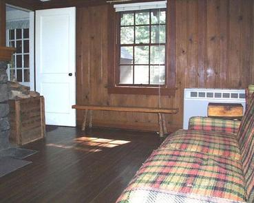
The Imnaha Guard Station is located in the southwest portion of Oregon’s magnificent volcanic Cascade Range, at an elevation of 3,800 feet. The facility offers a quiet remote setting and access to a multitude of recreational opportunities–an ideal destination for guests seeking both relaxation and outdoor activities. The cabin offers most of the amenities needed for a comfortable stay, though guests will need to bring some of their own supplies, such as lanterns or flashlights. This cabin does not feature indoor lighting.
Recreation
Hiking and wildlife viewing are popular among guests visiting this cabin.
Bird songs are common throughout the forest surrounding the cabin. The varied thrush and the hermit thrush are the “seldom-seen” inhabitants of the dense timber, though their distinct calls lift from the forest floor. The loud drumming of the dilapidated woodpecker, the largest woodpecker in North America, is also heard occasionally. Nuthatches, chickadees, and Steller’s jays are all common at Imnaha.
Diverse landscapes in the Rogue river-Siskiyou National Forest provide habitat for a wide-range of wildlife in the area, from spotted owls and bull elk to squirrels and salmon. These species, along with many others, depend on surrounding undeveloped wilderness, undisturbed wetlands, clean streams, and diverse forests to live.
Facilities
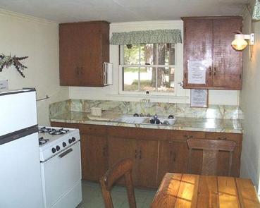
The Imnaha Guard House has a living room, bedroom, bathroom and kitchen, and is designed to accommodate up to six occupants. The bedroom is furnished with a full-size bed, a small closet and two dressers. The kitchen is equipped with a table and chairs, as well as a sink and small countertop for meal preparation. The bathroom has running water, a shower and flush toilet.
The stove and refrigerator are operated by propane, and potable water for drinking and cooking is available from the faucet. A picnic table in the backyard permits comfortable outside dining.
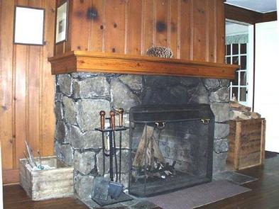
The cabin features a lava-rock fireplace in the front room. Firewood is stocked and stored outside and in the garage at the beginning of the season and intended for indoor use only. There are no guarantees of firewood. The supply may run low and what is there may have to be split by the visitor with the tools provided. Visitors should bring their own cookware, utensils and dishes, sleeping bags, towels, dish soap, matches, toilet paper and garbage bags.
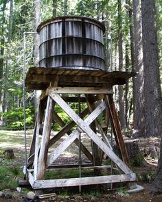
A very small Forest Service campground with four sites, also called Imnaha, is located within sight of the cabin. However, the cabin’s yard is fenced, and campers typically respect the privacy of the cabin occupants.
Natural Features
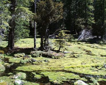
Imnaha Guard Station is surrounded by an old-growth forest composed of Douglas-fir, white fir, and incense cedar, as well as some ponderosa pine, sugar pine, and western white pine. A notably large, 300-year-old Douglas-fir, known as “The Big Tree,” towers above the canopy near the Imnaha cabin.
Imnaha Springs is just up a trail behind the cabin. The startlingly large volume of water that bubbles from the springs is crystal clear and almost ice cold. Imnaha Springs forms separate rivulets that flow along a scenic path through yellow monkeyflower and moss.
Nearby Attractions
Visit Crater Lake National Park and learn about its unique natural and cultural history. Reaching depths of 1,943 feet, Crater Lake is the deepest lake in the United States and one of the 10 deepest lakes in the world.