
Directions
From Jacksonville, OR, travel 8 miles south on Highway 238 to the community of Ruch, OR. From Ruch, OR, turn left on to Upper Applegate Road (County Road 859). Continue south approximately 8 miles to McKee Bridge Day Use Area, entrance is on the left.
Phone
541-899-3800
Activities
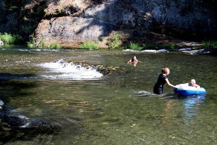
CAMPING, FISHING, WILDLIFE VIEWING, SWIMMING
Keywords
MCBK,ROGUE RIVER – SISKIYOU NF – FS
Related Link(s)
Overview
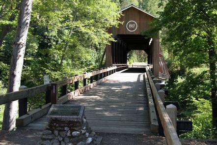
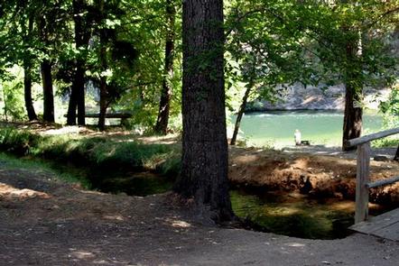
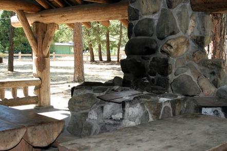
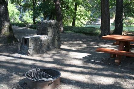
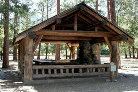
Situated along the rocky banks of the Applegate River, the McKee Bridge Community Kitchen is a fantastic day-use picnic shelter and registered National Historic Site. The shelter is constructed with large pine timber and features Civilian Conservation Corps (CCC) masonry, including a beautiful stone fireplace. Groups often reserve McKee Community Kitchen when holding a wedding ceremony on the neighboring historic covered bridge. Located in southwest Oregon in the Rogue River-Siskiyou National Forest at an elevation of 1,600 feet, this day-use area boasts nearby volcanic peaks, scenic rivers and fantastic old-growth forests.
Recreation
The area surrounding this day-use area offers outdoor enthusiasts the opportunity to hike, fish, swim, ski and enjoy a multitude of outdoor activities throughout the year.
Nearby Applegate Lake is a recreation lake located north of the spectacular Red Buttes Wilderness Area. The lake is popular for swimming, cycling, boating, canoeing, fishing and hiking the various trails.
Mule Mountain Trail offers visitors a special opportunity to access the hillsides above the Applegate Valley and witness the seasonal changes in wildlife activity. It is a long distance hike winding up and around the arid ridges of the Oregon Siskiyou Range. In the spring time, dwarf star tulips, lilies, shooting stars, larkspurs and buttercups puncture the needle and leaf mat and adorn the grass floor.
Facilities
The McKee Bridge Community Kitchen is a covered group site. Reservation is for Community Kitchen shelter. The nearby picnic area is separate and not included in the reservation.
Natural Features
The unique character of the Rogue River-Siskiyou National Forest is composed of two distinct geological provinces; the Cascade Range and the Siskiyou Mountains.
The Cascade Range is dominated by snow-capped volcanic peaks, such as 9,495 foot Mt. McLoughlin, located within the Sky Lakes Wilderness.
The Siskiyou area embodies the most complex and treasured plant communities in the Pacific Northwest. World-class wild rivers, biological diversity, remarkable fisheries resources and complex watersheds define the Siskiyou.
Diverse landscapes provide habitat for a wide-range of wildlife, from spotted owls and bull elk to salamanders and sandhill cranes.
Nearby Attractions
Squaw Peak Lookout: The United States Congress designated the Red Buttes Wilderness in 1984 and it now includes a total of 19,940 acres. Management of the Red Buttes Wilderness, located on the California/Oregon border, is shared by the Klamath National Forest and the Rogue River – Siskiyou National Forest. The majority of the Wilderness lies within the boundaries of the Rogue River-Siskiyou National Forest. Several lakes are accessible in the forest. Squaw Peak looks south to Squaw Lakes, a semi-primitive developed recreation area that accepts camping reservations from May through September. Applegate lake is a large reservoir with boat ramps, campgrounds, viewpoints and a developed recreation area named Hart tish. Both Squaw Lakes and Applegate lake are open for fishing year-round. Visitors enjoy Crater Lake National Park and learning about its natural and cultural history. At 1,943 feet deep, Crater Lake is the deepest lake in the United States and one of the ten deepest lakes in the world. Crater Lake is a 2 hour drive from Beaver Sulphur Campground.