

Directions
From Sula, travel northwest on Highway 93 for less than a mile. Turn northeast (right) onto East Fork Road/County Road 472 and continue about 16 miles to the cabin. Maps may be purchased by calling the Darby-Sula Ranger District at 406-821-3913.
Phone
406-821-3913
Activities
HISTORIC & CULTURAL SITE, CAMPING, FISHING, HIKING, WINTER SPORTS
Keywords
EFKC,BITTERROOT NF -FS
Related Link(s)
Overview
East Fork Cabin offers visitors a unique chance to camp in the Bitterroot National Forest of southwestern Montana. The cabin takes visitors back to a rustic, old-time setting and provides access to a variety of recreational opportunities on public lands. The site is available year-round and offers additional camping areas to accommodate large groups. An adjacent picnic area and pavillion provides a convenient location for everyone to gather. The cabin can be accessed by vehicle, however during winter months (October through April), alternative resources may be required to reach the cabin. The road is plowed up to three-quarters of a mile from the cabin. Guests are responsible for their own travel arrangements and safety, and must bring several of their own amenities.
Recreation
Fishing is popular in the nearby river. A variety of trout, including brown, rainbow, cutthroat and brook, can be found in the area between Sula and Conner. Winter fishing for whitefish is popular and productive, as the river is closed to trout fishing during the colder months. The catch along the East Fork is fairly evenly divided between bait, spin and fly fishermen.
The surrounding hills and valleys are popular for hiking, backpacking and horseback riding in the summer and fall. Cross country skiing, snowshoeing and snowmobiling can be enjoyed in the area during the winter (learn more about avalanche safety). Winter sports enthusiasts can enjoy more than 50 miles of groomed trails, along with a number of unmarked trails that are open for recreation.
Facilities
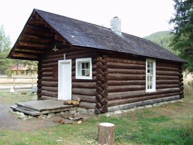
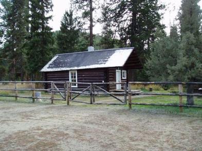
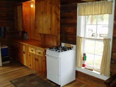
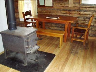
The small, one-room cabin can accommodate up to eight people. It is equipped with bunk beds and mattress pads, a table and chairs, counter and cupboard space and a propane cooking stove and oven. Propane is provided.
There are electric lights and one outlet for power. There is a wood stove for heat and firewood is provided. Pots, pans, plates and utensils are also available. Drinking water is available at the pump house and a vault toilet is located in an outhouse that is adjacent to the cabin. Toilet paper is provided.
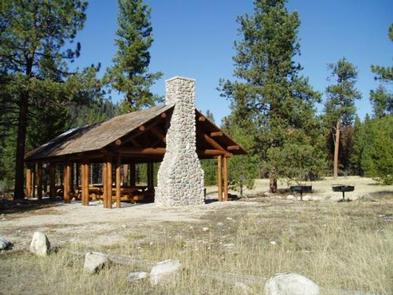
A large, log picnic shelter is also available at the site. It has a fireplace and two large charcoal grills. Even though there is a limit of eight people at the cabin, RV and tent camping is allowed in designated areas at the cabin. The site has a 35 person limit.
Guests will need to bring their own bedding, towels, soap and garbage bags. Guests are asked to replenish the supply of cut wood, as well as clean the cabin prior to their departure. Basic cleaning supplies are provided.
Natural Features
The rustic cabin was built before 1914 and was restored in 1987. It was originally a guard station, used by fire watchers in the forest. It is situated on the East Fork of Bitterroot River, at an elevation of about 5,200 feet. The river flows west from within the Anaconda-Pintler Wilderness, to just south of Conner, Montana, where it joins the West Fork of the Bitterroot River to form the Bitterroot River. During the spring the river becomes a dangerous combination of fast water and snags. The Anacondas are home to abundant wildlife, including mountain lions, elk, deer, moose and bears ( learn about outdoor safety ).