FALES FLAT CAMPGROUND, MT Campground Reservation, Info, Images, Map, Directions

FALES FLAT CAMPGROUND, Montana Campground Images, Info & Reservations

Directions

From Darby, travel south on Highway 93 for about four miles. Turn onto Highway 473 and continue southwest for 14 miles. Turn west onto Forest Road 468 and continue about 12 miles to the campground.

Phone

406-821-3269

Activities

BIKING, CAMPING, FISHING, HIKING, HUNTING, SCENIC DRIVE, HISTORIC SITES

Keywords

FFCG,Fales Flat,FALES FLAT CAMPGROUND,BITTERROOT NF -FS

Related Link(s)

Rec Area Info & Images

Montana State Road Conditions

Montana State Tourism

Overview

Fales Flat Campground is a group facility on Nez Perce Fork of the Bitterroot River. It is also well equipped for equestrian campers. The campground provides access to a variety of hiking and horseback riding trails in the area, as well as a variety of historic sites that denote the presence of the Nez Perce many years ago.

Recreation

Fly fishing and wading in the Nez Perce Fork, which runs alongside the campground, are also popular activities.

A variety of trails and unimproved roads are great for hiking and horseback riding. Three trails originate near the campground, including the Watchtower Trail and Sheephead Creek Trail which access the Selway-Bitterroot Wilderness and can be hiked as a loop. A steep, 2-mile trail leads to the historic Bare Cone Lookout.

Facilities

The campground offers one large group site for tent and RV camping. It can accommodate 15 to 100 people. Hookups are not available. Parking surfaces are gravel. The site is equipped with multiple tables and a large campfire circle. Vault toilets are provided. Drinking water and trash collection bins are not available. A few individual and equestrian sites are available at the campground on a first-come, first-served basis. Those sites have access to a horse staging area and hitching racks.

Natural Features

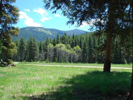
The campground is located in a large meadow at the base of Nez Perce Pass along the Nez Perce Fork of the Bitterroot River. The area is believed to have been used by the Nez Perce Nimi’ipuu tribe during its travels to the buffalo country in eastern Montana.

Nearby Attractions

The campground is about 23 miles from the town of Conner. A variety of services are offered there.

Reservation

More from CampingHiking.net:

SWEETWATER, California Campground Images, Info & Reservations

Directions From Fresno, California, take Highway 41 north. Turn northeast on Forest Road 200 and pass through North Fork. Take Minarets Road east and follow it 37 miles. Turn right on Mammoth Pool Road and follow it 2 miles to Sweetwater Campground. Phone 559-642-3212 Activities BOATING, CAMPING, FISHING, HIKING, SWIMMING

TABLE MOUNTAIN (ANGELES), California Campground Images, Info & Reservations

Directions From Wrightwood, California, take State Route 2 west for 2.4 miles to the Table Mountain Campground sign and continue to follow signs into the campground. Phone 760-249-3526 Activities BIKING, CAMPING, HIKING, WILDLIFE VIEWING, DAY USE AREA, SCENIC DRIVE Keywords TBLE,TABLE MOUNTAIN ANGELES NF,ANGELES NF – FS Related Link(s) Rec

HOOK POINT CABIN, Alaska Campground Images, Info & Reservations

Directions Access to the cabin is by wheeled plane on the beach at low tide only, 15 minutes from Cordova. The landing area is a half-mile from the cabin. Click here for local tide information. Inclement weather conditions may cause an extension of your trip during any time of the

GALLO CAMPGROUND, New Mexico Campground Images, Info & Reservations

Directions From the North: Driving from Albuquerque or Farmington, NM, drive on Highway 550, exit to County Road (CR)7900 at mile marker 112; drive CR 7900 then turn westbound to CR 7950 which will turn into a dirt road after three miles. Drive 13 miles of dirt road to reach

FORT SPOKANE, Washington Campground Images, Info & Reservations

Directions Take State Highway 2 west of Spokane for 32 miles. Turn north on State Highway 25 at the town of Davenport and travel 24 miles. Follow the signs to the campground. Phone 509-754-7889 Activities BIKING, BOATING, HISTORIC & CULTURAL SITE, CAMPING, INTERPRETIVE PROGRAMS, FISHING, HIKING, PICNICKING, VISITOR CENTER, WATER

CLARKS FERRY, Iowa Campground Images, Info & Reservations

Directions From Davenport, Iowa, drive west on Hwy 22 about 15 miles and turn at Clark’s Ferry Sign (in Montpelier) Phone 563-419-7594 Activities BOATING, CAMPING, FISHING, DAY USE AREA, BIRDING Keywords CLAR,MISSISSIPPI RV. RI Related Link(s) Rec Area Info & Images Iowa State Road Conditions Iowa State Tourism Overview Clarks