

Directions
From Bozeman, MT: Drive west towards Four Corners, then south towards Big Sky/West Yellowstone on US Highway 191 for about 40 miles to the Big Sky turnoff. From here there are three different travel options depending on the season and mode of travel. 1. (June 16 – December 1, weather and snow conditions permitting) Drive south on US Hwy 191 3.75 miles. Turn right (west) onto Buck Creek Ridge Road FS 2599. Drive for 7.7 miles to the Buck Creek Ridge Trailhead. All highway vehicles must park here. Travel for 9.5 miles on Buck Creek Ridge Trail 10. At the junction of Trail 467 to Yellow Mule Cabin, take a right (north) and switchback down about 1/3 mile to the cabin. Winter Route, December 2 to June 16: Park in the lot across from the entrance to Buck Creek Ridge Road on the east side of US Hwy 191. The cabin is approximately 17.5 miles from the parking area. 2.Drive south on US Hwy 191 for about 5.2 miles from the Big Sky turnoff. Turn right (west) into the Lower Buck Creek Trailhead just past the Corral Bar and Steak House. All cars and trucks must park there. Take Trail 610 which leaves the Trailhead parking area to the north. Travel for 4 miles. This route travels through private land, please stay on the trail. Trail 610 then joins FS Road 2599. Turn left (south) on FS Road 2599 and travel for 5.1 more miles to the Buck Creek Ridge Trailhead. From here travel for 9.5 miles on Buck Creek Ridge Trail 10. At the junction of Trail 467 to Yellow Mule Cabin, take a right (north) and switchback down about 1/3 mile to the cabin. The cabin is approximately 18.6 miles from the trailhead. This route can be used in the summer or winter. In the winter follow the orange diamonds. 3. Non-Motorized: From the Big Sky turnoff and junction with US Hwy 191, turn right (west) onto Lone Mountain Trail/State Highway 64 for 2.9 miles. Turn left (south) onto Ousel Falls Rd. and travel for 1.8 miles to the Ousel Falls Trailhead which is on the south side of the road (left). Take FS Trail 162 southwest for 8.3 miles to the junction with FS Trail 10. Travel right (west) on Trail 10 for approximately 1.5 miles. At the junction of Trail 467 to Yellow Mule Cabin, turn right (north) and switchback down about 1/3 mile to the Cabin. ROAD CLOSURE INFORMATION: (Please refer to the Motor Vehicle Use Map ) December 1 to June 16 Buck Creek Ridge Road 2599 and the Buck Creek Ridge Trail 10 are closed to all wheeled motorized vehicles. This is a groomed multi-use winter trail. Please obey traffic rules. Ride on the right side of the trail and ride with caution. Snowmobiles and bicycles must purchase a winter trail grooming pass to travel on groomed snowmobile routes. Contact Montana, Fish Wildlife and Parks for details. ALL WINTER USERS: Please read the Gallatin National Forest avalanche advisory: www.mtavalanche.com , or call (406) 587-6981.
Phone
406-522-2520
Activities
HISTORIC & CULTURAL SITE, CAMPING, HIKING, HUNTING, WILDLIFE VIEWING, MOUNTAIN BIKING, OFF ROAD VEHICLE TRAILS, SNOWMOBILE TRAILS
Keywords
YELM,YELLOW,MULE,GALLATIN NF – FS
Related Link(s)
Overview
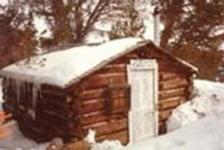
Yellow Mule Cabin was built in 1920 and was once used as a ranger station. This cabin is unique because it was constructed according to the builder’s preference instead of being built with a standard Forest Service design. It is eligible for nomination to the National Register of Historic Places. The cabin provides a rustic, backcountry retreat year-round. A few basic amenities are provided, so guests should be prepared to bring most of the supplies and gear they need for an enjoyable experience. This remote cabin is not accessible by car. Summer access is via off-road vehicle, motorcycle or hiking for 8 miles. Winter access is by snowmobile for 14 miles.
Recreation
This cabin is popular with snowmobilers because of its proximity to the Buck Creek Ridge Trail, which offers a 1,000 foot elevation gain. Hikers, mountain bikers and off-road vehicle riders enjoy this trail in the summer. Snowmobilers and cross-country skiers can also access McAtee Basin. Hunting in designated areas is another popular pastime.
Facilities
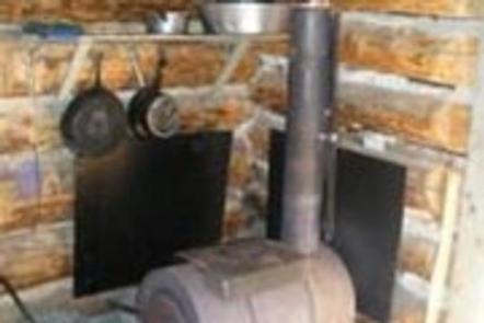
This 12 x 14 single-room cabin can sleep up to three people and comes with three cots. A wood stove is provided for heat. Basic cookware, utensils, a propane lantern and a dining table with chairs are available. An outhouse with a vault toilet is located just outside. Water, electricity, cooking facilities and firewood are not provided. Guests must bring their own water supply and trash bags to pack out trash, as well as bedding, matches, first aid supplies, extra toilet paper and battery-operated lanterns or flashlights.
Natural Features
The cabin sits between a meadow and a stand of mixed evergreens at an elevation of approximately 8,650 feet. Wildflowers bloom across the meadow in the summer and a thick layer of pristine snow blankets the area in winter. The jagged, glaciated peaks of the Madison Mountain Range stretch out into the distance. Wildlife in this area includes grizzly bear, gray wolf, mountain lion, deer, elk, moose, bighorn sheep and the Canada lynx. Birders may see a wide variety of bird species.