
Directions
There is no motorized access to this cabin. There are two travel options to Fox Creek Cabin: 1. South Cottonwood Trailhead. From Bozeman, MT: Drive south on S. Cottonwood Road for about 7 1/2 miles. Turn left onto Cottonwood Canyon Road and drive about 2.1 miles to the end of the road and the South Cottonwood Trailhead. Travel approximately 6 miles on S. Cottonwood Trail 422 to the junction with the History Rock Trail 424. Travel about 1/4 mile more on History Rock Trail 424. Look for a side trail on your right. Travel this trail and follow the signs about 1/4 mile more to the cabin. This is the recommended winter route (December 2 through June 15). The cabin is small and nestled in trees and may be difficult to find when snow covered. 3. Langohr. From Bozeman, MT: Drive south on S. 19th Ave. for about 7 miles. Turn left onto Hyalite Canyon Road FS 62. Drive 6.3 miles on Hyalite Road 62 to the intersection with Langohr Road FS 6230 (closed December 2 – June 15). Drive about 5 miles up FS Rd 6230 to the end of the road (stay on FS Road 6230). Take the path to the south to join with Trail 424 and travel west (right). Hike, bicycle or horseback ride for a total of about 2.5 miles to the junction with the cabin access trail, which is about a 1/4 mile before you reach the South Cottonwood Trail 422. ROAD CLOSURE INFORMATION: (Please refer to the Motor Vehicle Use Map ) Hyalite Canyon Road, FS 62, closes to all motorized vehicles the evening of March 31 through May 15. Hyalite Canyon Road FS 62 is intermittently plowed during the winter.
Phone
406-522-2520
Activities
BIKING, CAMPING, FISHING, HIKING, HUNTING, WINTER SPORTS, WILDLIFE VIEWING
Keywords
FOXR,FOX,CREEK,GALLATIN NF – FS
Related Link(s)
Overview
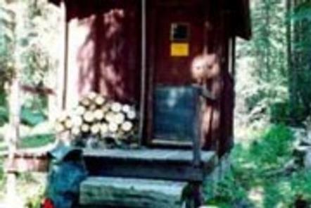
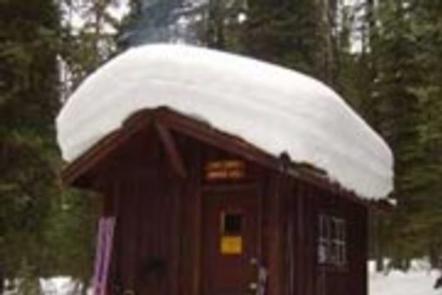
Fox Creek Cabin is a former ranger station located in a remote area. It is very small and offers only basic amenities. Guests will need to bring most of the gear and supplies they need to have a comfortable and enjoyable stay. The cabin is located in a non-motorized area and can only be accessed by a 2.5-mile hike during the summer months, from the end of Langohr Road. A four-wheel drive vehicle is recommended for driving on Langohr Road. Winter access to the cabin requires hiking, skiing or snowshoeing about six miles from the South Cottonwood Trailhead.
Recreation
The South Cottonwood and History Rock Trails are used to access the cabin and are available for hiking, mountain biking, snowshoeing and cross-country skiing, depending on the conditions. Both trails connect to the Mount Blackmore Loop Trail, which offers views of the Hyalite Canyon at the summit of Mount Blackmore before descending to Blackmore Lake. Fishing is possible in the area, as well as hunting in the fall.
Facilities
The cabin has bunk beds with mattresses to accommodate up to two people. A small wood stove can be used for heating and cooking. A table with chairs, basic cookware, dishes, utensils and cleaning equipment are provided. An outhouse is equipped with a vault toilet. Electricity and water are not provided. Guests must bring their own water supply and flashlights or lanterns. Guests should also bring their own bedding, dish soap, toilet paper, garbage bags and other supplies. The cabin will need to be cleaned and all trash carried out prior to departure.
Natural Features
The cabin sits at an elevation of approximately 6,700 feet, next to South Cottonwood Creek in the midst of the Gallatin Mountain Range. It is situated in a small clearing surrounded by thick evergreen forest, so it is well hidden from the trails used to reach the cabin. The access trails offer scenic views of wildflower meadows and 10,154-foot Mount Blackmore. Wildlife in this area includes grizzly and black bears, gray wolves, mountain lions, deer, elk, moose, bighorn sheep and Canada lynx. Birders may see a wide variety of bird species.