


Directions
Travel west on Highway 43 from Wisdom, Montana for approximately 20 miles. Turn north on the Trail Creek Road #106, travel for approximately 6 miles to the cabin. It will be located on the left (west) side of the road. Access 1 This route takes off from the Chief Joseph Pass cross country ski parking area. Travel north on the Broadway Trail for about one mile until the trail intersects with FS road #1260. The first mile is for skiers only. The remaining road is shared by both skiers and snowmobiles. The route is marked with blue and orange diamonds. This route is recommended for the novice or inexperienced skier. The total distance is 6 miles. Access 2 Shoofly Trail #3117 is the shortest route into Hogan Cabin and also the most difficult. This trail takes off from the parking area along Highway 43 by the Cabinet Creek sign. There are a few sections with steep pitches and most of the difficult sections are tree-lined. If you choose the Shoofly Trail, consideration should be given to snow conditions and skier experience. This trail is marked with blue diamonds. Access 3 Shoofly Alternate: This trail leaves the Shoofly trail from the north end of the meadow and it rejoins Shoofly at the top of the hill. The Shoofly Alternate offers skiers going to Hogan Cabin a more gentle ascent of the hill. If snow conditions are poor when you are returning from the cabin or you are not comfortable with the faster downhill that Shoofly offers, this route may be advisable. It is marked by blue diamonds. Access 4 Trail Creek Road #106 is the main snowmobile route into the area and is marked with orange diamonds. It is also the flattest route into Hogan Cabin. Skiers should expect encounters with snowmobiles if they use this route. It is 6 miles to Hogan Cabin on this road. A map of the area may be necessary to reach the cabin and can be purchased by calling the Wisdom Ranger District.
Phone
406-689-3243
Activities
HISTORIC & CULTURAL SITE, CAMPING, HIKING, WINTER SPORTS, WILDLIFE VIEWING
Keywords
HOGA,HOGAN,BEAVERHEAD-DEERLODGE NF -FS
Related Link(s)
Overview
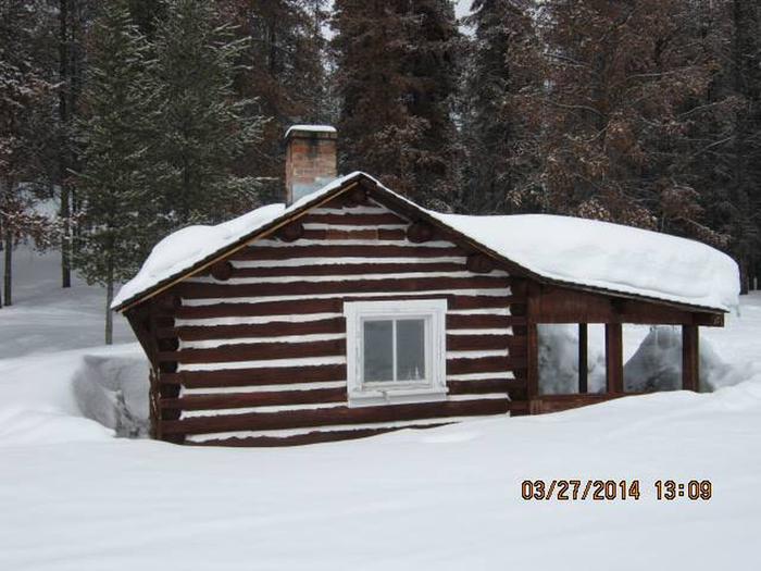
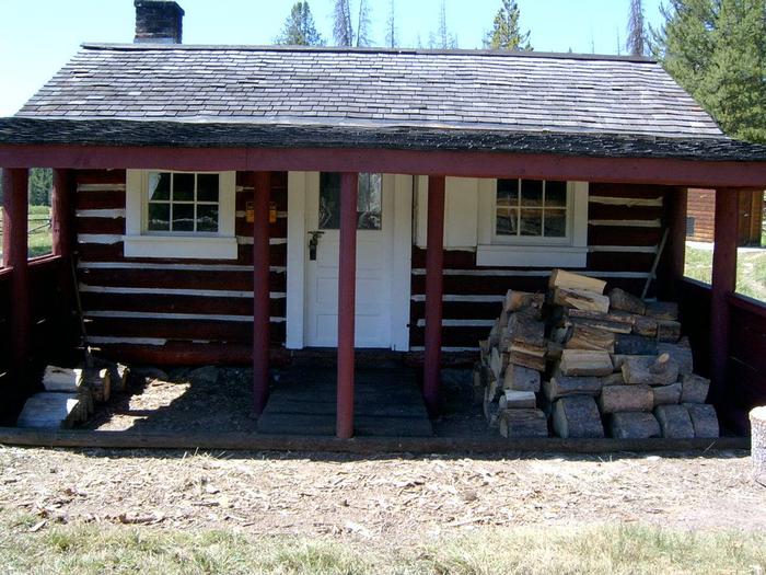
Hogan Cabin is a small cabin located on the Lewis and Clark National Historic Trail in western Montana. The cabin was built in the 1920s to provide field quarters for trail crews, smoke chasers, timber cruisers and grazing inspectors that worked in the area. It is a great retreat for snow lovers in the winter, as the cabin provides access to a variety of snowmobiling, cross-country skiing and snowshoeing trails. Summer and fall months give guests plenty of daylight and moderate temperatures to explore the surrounding meadows, peaks and valleys, as well as fish in plentiful mountain streams. The cabin is only accessible by motorized vehicle during the summer months and until snow closes the road. Guests may have to snowmobile, hike or ski up to six miles, depending on conditions. Guests are responsible for their own travel arrangements and safety, and must bring several of their own amenities.
Recreation
The surrounding hills and valleys are popular for hiking and backpacking in the summer and fall, and for cross-country skiing, snowshoeing and snowmobiling in the winter. The cabin sits along the famous Lewis and Clark Trail, which led frontier explorers through the area in the early 1800s. The entire length of the trail covers 4,600 miles, showcasing some of the most beautiful and rugged areas of America. Hunting and fishing are also popular in the area. Mountain creeks and streams run near the cabin, and wildlife is abundant in the surrounding forest. It is also a popular place to watch for various bird species.
Facilities
The one-room log cabin has bunk beds and mattresses to sleep up to four people. It has a table and chairs, a propane stove, propane lantern, and a variety of cooking, eating and cleaning equipment. A wood stove is available for heat, and firewood and an axe are provided from September 16-June 15. Firewood is not provided from June 16-September 15. An outhouse with vault toilet and a campfire ring with grill are located nearby. The cabin has no electricity or running water. Guests will need to bring water for drinking, cooking and cleaning purposes, as well as small propane canisters for the stove and lantern. Guests also need to bring their own bedding, food, towels, soap, matches and flashlights, toilet paper, garbage bags and other necessities. There is no cell phone service available at the cabin. Guests are required to pack out all trash and food and clean the cabin prior to leaving.
Natural Features
The cabin is situated on the Lewis and Clark National Historic Trail at an elevation of about 7,300 feet. It is at the southwestern end of the Anaconda Mountains, near the Sapphire Range, in the Beaverhead-Deerlodge National Forest.
The Anacondas are home to abundant wildlife, including mountain lions, elk, deer, moose and bears (learn more about bear safety).