
Directions
Deer Creek Cabin is located approximately 30 miles south of Big Timber, Montana. It can be accessed by 3 different routes. It is recommended that renters carry topographic maps, GPS and compasses for navigation since the route may be difficult to find. One route to follow is the Placer Gulch Trailhead access by foot, horse, or OHV (50 inches or less): From Exit 370 on Interstate 90 just east of Big Timber, take Frontage Road (south side of the interstate) 8 miles east. Turn right (south) onto Lower Deer Creek Road (Forest Service Road #482) and proceed 16.2 miles to the Placer Gulch Trailhead sign located on the left side of the road. Park at the trailhead and travel Placer Gulch Trail 256 by foot, horse or off-road vehicles a distance of 5.2 miles, to the Deer Creek Cabin. Jim’s Gulch Trailhead access by foot or horse: From Big Timber, travel 14 miles east on Interstate Highway 90 to Exit 384, Bridger Creek. At the stop sign, turn right and travel south for 8.2 miles to the junction of Main Bridger with West Bridger Creek Road. Turn right and continue on West Bridger Road for 4 miles, to the parking area. Park near the sign for Jim’s Gulch Trail 129, Lower Deer Creek. From this point, the cabin is 4 miles by foot or horse. Follow trail 129 up Jim’s Gulch for about a mile, where the trail turns sharply to the right (north) and climbs up to the ridge. Follow the trail to the divide where it descends steeply to Lower Deer Creek. At this point, the trail junctions with Lower Deer Creek Trail 5. Turn left (south) on Trail 5 and follow the trail upstream for approximately 1.5 miles to the cabin. Tie Cutter Trail Head 370 access by ATV: Go one quarter mile past Jim’s Gulch Trailhead to Tie Cutter Trailhead. This ATV trail climbs up to a ridge, then drops into Lower Deer Creek , accessing Deer Creek Cabin and other motorized trails. During winter months, the road to the trailhead may not be plowed and could be impassable to both passenger cars and four-wheel drive vehicles. Please call the Livingston Office of the Yellowstone Ranger District at (406) 222-1892 for road conditions.
Phone
406-222-1892
Activities
CAMPING, HIKING, WINTER SPORTS
Keywords
DECC,DEER,CREEK,GALLATIN NF – FS
Related Link(s)
Overview
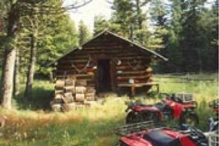
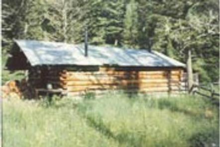
The Todd Family began building Deer Creek Cabin in 1953 and finished it in 1960. They used it as a retreat while they grazed cattle on federal lands in the summer and hunted in the fall. The cabin has survived two forest fires. Gallatin National Forest assumed ownership of the cabin in 1993.
The cabin is open year-round, but access is challenging. There are three routes to the cabin that can be used by equestrians, hikers and ATVs in the summer. During the winter, by snowshoes, skis and snowmobiles. Snowmobilers will need to park their trailers down low on the Iron Mountain Road, keeping the road passable for others. These trails will be marked as to uses. These 4- to 5-mile routes ford creeks many times, with creek depths varying from 6 inches to several feet, in the spring.
Some basic conveniences are provided, but guests will need to bring most of their own amenities to ensure a comfortable stay.
Recreation
There are numerous trails around the cabin that provide opportunities for exploration. Experienced cross-country skiers and snowshoers will find a challenging winter landscape.
Anglers can fish for trout in the nearby creek. The area offers good big game and bird hunting opportunities in the fall.
Facilities
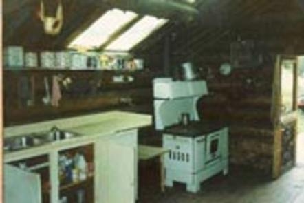
The single-room cabin has a wood cook stove and a wood heating stove. It can sleep up to four people on a provided double bed and set of bunk beds with mattresses. Other amenities include basic cooking supplies, a table with chairs, some cleaning gear, propane-fueled lantern,propane-fueled cookstove, axe, maul, bucket and shovel. Bring propane canisters for the lantern and stove. A campfire ring and outhouse with pit toilet are located outside the cabin. Livestock may be kept at the available adjacent corral and in partially fenced pasture. No water or electricity is provided. Guests must bring their own drinking water or treat water taken from the creek. Items such as battery-powered flashlights or lanterns, bedding, matches, extra toilet paper and dish soap are not provided.
Natural Features
This remote location provides habitat for a variety of wildlife, including bear, moose, antelope, elk and deer. Many species of birds also inhabit the area.
Blackened trees from a 2006 forest fire still line the nearby hillsides.