TIMBERLANE CAMPGROUND, MT Campground Reservation, Info, Images, Map, Directions

TIMBERLANE CAMPGROUND, Montana Campground Images, Info & Reservations

Directions

From Libby, Montana, cross the Kootenai River Bridge on Highway 37, go approximatley 1 mile and turn north onto Pipe Creek Road 68, which leads to the town of Yaak and Turner Mountain Ski Area. Travel 8 miles to the gate, which is approximately 1 mile past the community of Pipe Creek.

Phone

406-293-7773

Activities

BIKING, CAMPING, FISHING, HIKING, WILDLIFE VIEWING

Keywords

TICA,TIMBERLANE,CAMPGROUND,TIMBER,LANE,KOOTENAI NF – FS

Related Link(s)

Rec Area Info & Images

Montana State Tourism

Montana State Road Conditions

Overview

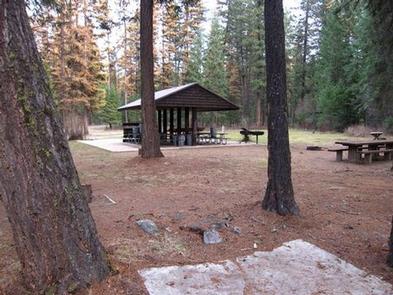
Timberlane Campground group site is located along a forest creek and in an area thick with towering trees. Several hiking trails exist in the area. The group pavilion accommodates up to 100 people and is set up for reunions and receptions. Its a great place to enjoy the Kootenai National Forest.

Recreation

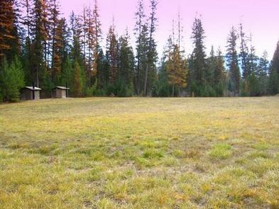
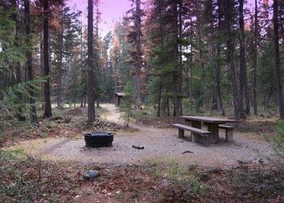
Horseshoe pits, a volleyball court and a large, grassy play field are available at the campground. Pipe Creek allows visitors to enjoy fishing and swimming in the clear mountain water. The campground and picnic area are surrounded by a 1-mile hiking trail.

Visitors also enjoy scenic drives, biking and watching for wildlife along any of the roadways in the area. Pipe Creek Road heads deep into the surrounding forest.

Facilities

The Timberlane group stie has a 20′ x 20′ shelter, with picnic tables, a grill, and one 15 amp electric plug in. If you need to power anything in excess of 15 amps, you will need to bring a generator. The site provides vault toilets.  

Natural Features

The Timberlane campground and group site is located along Pipe Creek in the Kootenai National Forest of northwestern Montana. It lies in a mixed conifer forest at an elevation of about 2,600 feet. A variety of wildlife make its home in the area.

The area is historically significant, once a former habitat and hunting ground for the Kootenai Tribe. Certain parts of the forest remain sacred to the tribe, including a location on Pipe Creek that contains soft, multicolored stone, which was used to carve bowls for tobacco pipes used in ceremonies. Pipe Creek used to produce stones of several different colors.

Nearby Attractions

Timberlane Campground is near the David Thompson Historic Route, the 67-mile Lake Koocanusa Scenic Byway and the Scenic Tour of the Kootenai River bike route.

The town of Libby is nearby, making the campground a perfect location for overnight stays during the wildly popular Logger Days, various car club events and Nordicfest.

Reservation

More from CampingHiking.net:

INDIAN FLATS CABIN, Montana Campground Images, Info & Reservations

Directions Indian Flats Cabin is located 40 miles northeast of Helena. Take Highway 280 east from Helena. Several miles after crossing the Missouri River, you will come to the small community of York. Turn left at the York Bar and proceed 5 miles to the smaller community of Nelson, where

BREVOORT LAKE CAMPGROUND, Michigan Campground Images, Info & Reservations

Directions N4149 Brevort Camp Road Moran Michigan 49760 From St. Ignace, Michigan, take Highway 2 west for about 20 miles. Turn north on Brevort Camp Road/Forest Service Road 3108, then right at Forest Service Road 3473 and continue to the campground entrance. Phone 906-203-9872 Activities BIKING, BOATING, CAMPING, FISHING, HIKING,

LITTLE MILL, Utah Campground Images, Info & Reservations

Directions From Salt Lake City or Provo, take I-15 to the Alpine-Highland exit 284. Travel 8 miles east on Utah Highway 92 to the mouth of American Fork Canyon. Stay on 92 for 4 miles to the campground. Phone PLEASANT GROVE RANGER DISTRICT 801-785-3563 OR UTAH RECREATION COMPANY 385-273-1100 Activities

PAT MAYSE WEST, Texas Campground Images, Info & Reservations

Directions From Paris, TX, take HWY 271 north for 12 miles to FM 906 W, then 4 miles to FM 197. Turn west for 3 miles to CR 35810, turn left 1 mile to CR 35800, then left into the park. Phone 903-732-4956 Activities CAMPING, FISHING, HUNTING, SWIMMING, WATER ACTIVITIES,

BIG SPRINGS – CARIBOU, Idaho Campground Images, Info & Reservations

Directions Just east of Lava Hot Springs, Idaho, look for "Pebble Area" sign and turn left onto Blaser Highway/Old Highway 30. Go north on the paved highway 9 miles to Pebble Creek Road, known locally as Mike’s Place or Whiskey Mike’s. Turn left across railroad tracks on gravel Forest Road

SUNGLOW CAMPGROUND, Utah Campground Images, Info & Reservations

Directions Travel a half-mile south of Bicknell, Utah, on Highway 24, then turn east on Forest Road 143 and travel 1.5 miles to the campground. Phone 435-836-2811 Activities CAMPING, HIKING Keywords SUNG,FISHLAKE NF – FS Related Link(s) Rec Area Info & Images Utah State Road Conditions Utah State Tourism Overview