WILD PLUM, CA Campground Reservation, Info, Images, Map, Directions

WILD PLUM, California Campground Images, Info & Reservations

Listen

Directions

From Sierra City travel north (east) on Highway 49 for about a half a mile, turn right onto Wild Plum Rd and continue for another 1.5 miles. You will arrive at Wild Plum Campground after crossing the Haypress Creek bridge.

Phone

(530)478-6253

Activities

BIKING, CAMPING, FISHING, HIKING, HORSEBACK RIDING, HUNTING, SWIMMING, MOUNTAIN BIKING, KAYAKING, WATER ACCESS, SCENIC DRIVE, BACKPACKING

Keywords

WIPL,WILDPLUMB,TAHOE NF – FS

Related Link(s)

Rec Area Info & Images

California State Tourism

California State Road Conditions

Overview

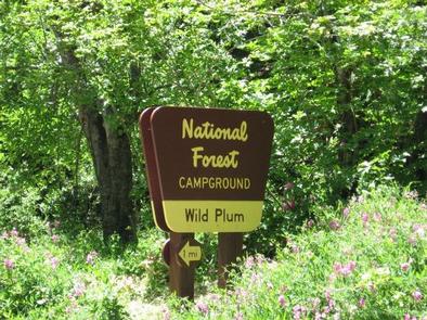
Wild Plum Campground is located on Haypress Creek in the North Yuba River area. Visitors enjoy a wide variety of recreational activities in the area, including hiking, biking, hunting, fishing, and gold panning. this facility is operated and maintained by the Tahoe National Forest.

Recreation

Wild Plum Loop Trail can be accessed from the campground. The 2.5-mile trail is open to hiking and horseback riding and provides access to the Pacific Crest Trail and Haypress Trail. The scenic and historic town of Sierra City is just two miles from the campground. A variety of lodging and dining options are available.

Facilities

The campground offers several single-family sites, many of which are designated for tent camping only. Each site has a picnic table and campfire ring. Vault toilets and drinking water are provided. The campground’s two smaller loops have paved roads and parking spurs; the larger upper loop has a gravel road and spurs.

Natural Features

The campground is situated on the banks of Haypress Creek. A forest of hardwood and pine trees covers the area, offering pleasant shade. Many rocks, from early gold dredging activity, cover the forest floor. Several sites overlook the creek.

Nearby Attractions

Wild Plum Campground is located about 1 mile east of historic Sierra City which is on the Yuba Donner Scenic Byway (Highway 49) near many gold rush era historical sites and scenic mountain vistas. Gold Lakes Basin offers boating, fishing, biking, and hiking. Boating, fishing, and swimming are available at nearby Sardine Lakes, about 7 miles north of the campground. Sardine Lakes Resort offers boat rentals. Anglers will find rainbow and brook trout in many of the lakes, streams, and rivers throughout the basin. Over 30 miles of maintained trails for hiking, mountain biking, and motorcycle singletrack branch out across the area and the Pacific Crest Trail can be accessed from with in the campground as well as at a few spots in the Lakes Basin area. The historic town of Sierra City offers historic and cultural attractions, restaurants, shops, churches, and vistor information.

Reservation

More from CampingHiking.net:

SHORELINE, Idaho Campground Images, Info & Reservations

Listen Directions From Boise, Idaho, travel 85 miles north on Highway 55 to Cascade. Turn east on Warm Lake Highway and go 25 miles to Forest Road 489. Turn south and continue a half-mile to the campground. Phone 208-382-7400 Activities BIKING, BOATING, CAMPING, FISHING, HIKING, HUNTING, WILDLIFE VIEWING, SWIMMING SITE

Trapper Creek Campground, Oregon Campground Images, Info & Reservations

Listen Directions From I-5 take exit 188A, heading west on Highway 58 for 62.4 miles, then continue 1.9 miles south on Road 5810 to the campground. Phone 541-323-1746 Activities BIKING, BOATING, CAMPING, FISHING, HIKING, WATER SPORTS, SWIMMING SITE Keywords TRPC,Trapper,Trap,Shelter Cove,Odell,Trapper Creek,Trapper Creek Campground Related Link(s) Rec Area Info &

EAST FORK CAMPGROUND, Colorado Campground Images, Info & Reservations

Listen Directions From downtown Pagosa Springs, travel 11 miles east on Highway 160 to the junction with East Fork Road (Forest Road 667). Turn right and continue less than a mile to the campground on the right. Phone 970-264-5255 Activities BIKING, CAMPING, FISHING, HIKING Keywords None Related Link(s) Rec Area

The Dalles Campground, Washington Campground Images, Info & Reservations

Listen Directions From Enumclaw, Washington, go southeast on Highway 410 towards Mt. Rainier park for approximately 26 miles to campground. Phone 360-804-1103 Activities CAMPING Keywords DALS,MT. BAKER-SNOQU NF – FS Related Link(s) Rec Area Info & Images Washington State Road Conditions Washington State Tourism Forest Service Concessionaire Overview Situated on

Gold Bar Group Sites, Utah Campground Images, Info & Reservations

Listen Directions From Moab, drive five miles north on Hwy 191 to the intersection with Hwy 279. Turn left/west on Hwy 279 and drive ten miles to the campground entrance road. Phone 435-259-2100 Activities BIKING, BOATING, CLIMBING, CAMPING, HIKING, OFF HIGHWAY VEHICLE, RECREATIONAL VEHICLES, PHOTOGRAPHY, PADDLING, MOUNTAIN BIKING, OFF ROAD

TUOLUMNE MEADOWS, California Campground Images, Info & Reservations

Listen Directions Take Highway 41 north from Fresno, Highway 140 east from Merced, Highway 120 east from Manteca or west from Lee Vining (State Route 395) into Yosemite National Park. Tuolumne Meadows Campground is located 5 miles from the Tioga Pass Entrance station (Hwy 120 from the east), and is