

Directions
All mileage is approximate from the highway.
From Helena, take Highway 287 for 26 miles southeast towards Townsend, Montana. Turn right on Indian Creek Road just before crossing the Missouri River. Travel for 3 miles, then turn left onto Forest Road #4031 (purple sign). Travel 5 miles to an intersection and stay to the right. This road will lead down a hill, into a narrow canyon and under a conveyor belt for the current mining operations in that area. Stay to the left, but continue on Forest Road #4031 for another 2.5 miles. Turn right and travel 0.5 miles to the cabin.
From December 2 through May 15, the last 4 miles are not open to motorized vehicles. Access to the cabin is by foot, ski, or horseback.
Phone
406-266-3425
Activities
BIKING, HISTORIC & CULTURAL SITE, CAMPING, FISHING, HIKING, HORSEBACK RIDING, HUNTING, WINTER SPORTS, WILDLIFE VIEWING
Keywords
EGLE,HELENA NF – FS
Related Link(s)
Overview
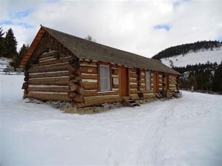
Eagle Guard Station is located in high grasslands and surrounded by a scattered forest in the Elkhorn Mountains in west-central Montana.
The former Eagle Creek Ranger Station was built by miner Richard Owen in 1895. While his family lived there, the area was in a booming gold rush. In 1908, the cabin was taken over by the Forest Service for administrative use. It is the oldest administrative log structure on the Helena National Forest, predating the establishment of the Forest.
Today the cabin is a rustic retreat for guests seeking relaxation and recreation. The cabin is accessible by car, but the last 4 miles are only open to foot, horseback and cross-country ski traffic from December 2nd through May 15th. Several amenities are provided, but guests should be prepared to pack in some of their own supplies and gear.
Recreation
Eagle Guard Station provides guests with outstanding opportunities for photography, fishing, hunting, and hiking.
The area offers centralized access to the Elkhorn Mountains with numerous hiking trails and roads leading to the Elkhorn’s historical resources. Popular hikes include those to Crow Creek Falls and Poe Park. An interpretive trail is accessible just beyond the cabin.
When snow allows, skiing gives visitors an up-close look at concentrations of wintering elk.
Facilities
The entire site consists of the cabin, a woodshed, vault toilet, barn, horse corrals and a fire ring. The cabin can accommodate up to six people on three sets of bunk beds with mattresses. A wood stove provides heat and a propane camp stove can be used for cooking. The kitchen is equipped with a table and chairs, dishes, propane lantern, utensils and cookware.
An axe and snow shovel are provided. Firewood may be available, but it is not guaranteed.
There is no available potable water or electricity at this facility. Guests must bring a sufficient amount of water for drinking, cooking and washing, as well as one or two small propane canisters to use with the propane stove and lantern.
Guests need to provide their own sleeping bags, flashlights, linens, towels, dish soap, matches, first aid kit, toilet paper and garbage bags. All trash and food should be packed out, and guests should clean the cabin before leaving.
No firewood provided from June 1st – August 31.
Natural Features
Eagle Guard Station is situated on the southeast flanks of the Elkhorn Mountains in a beautiful open grassland setting, an outstanding location for viewing elk.
Crow Creek Falls, the largest waterfall in Helena National Forest, is located within hiking distance of the cabin and is a sanctuary for many wildlife species, including the threatened Canada lynx, the sensitive goshawk and westslope cutthroat trout.
The area offers unique opportunities for viewing wildlife in their natural habitat. Bighorn sheep, mule and white-tailed deer, black bear, moose and a variety of birds are commonly seen. The more elusive badger, wolverine and mountain lion find habitat here as well.
Nearby Attractions
Historic town sites and mining areas such as Elkhorn, Hassel, Ruddville and Diamond Hill mines are nearby for guests interested in the mining history of the Elkhorns.