
Directions
From Kemmerer, WY, follow U.S. Highway 189 north to the junction of Wyoming Highway 233 and Ham’s Fork Road. Turn left on Ham’s Fork Road and drive about 38 miles (the first 19 miles of this road is paved) to Ham’s Fork Campground. Just past the campground, take the left fork in the road and cross Ham’s Fork River. Drive about 2.5 miles to Green Knoll/Forest Road 10198 junction and turn left. Then drive 3.8 miles to Nugent Park/Forest Road 10069 junction and turn right. Drive 0.8 miles to Kelley Guard Station Road and turn right. The guard station is about 1/2-mile from the junction.
Winter access is by snowmobile only on a 10-mile trail.
Phone
307-877-4415
Activities
BIKING, CAMPING, FISHING, HIKING, HORSEBACK RIDING, HUNTING, WINTER SPORTS, WILDLIFE VIEWING
Keywords
KELC,KELLEY CABIN,BRIDGER-TETON NF – FS
Related Link(s)
Overview
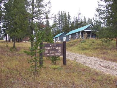
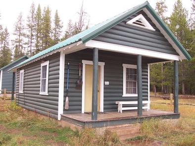
Kelley Guard Station is a historic Forest Service guard station built by the Civilian Conservation Corps in 1933. Located about 45 miles north of Kemmerer, Wyoming, along the Big Springs Scenic Backway, the cabin attracts overnight guests year-round and provides convenient access to hiking, mountain biking, cross country skiing and snowshoeing.
Big Springs Scenic Backway is a 68-mile road that boasts magnificent mountain views, wildflowers covered meadows and river valleys where grazing sheep may be spotted.
Recreation
Hiking, mountain biking, horseback riding, fishing and off-road vehicle riding are popular summer activities in the surrounding area. Snowmobiling and cross country skiing can be done right out the front door in winter.
Facilities
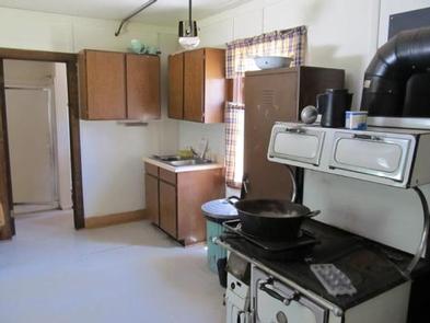
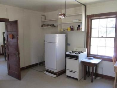
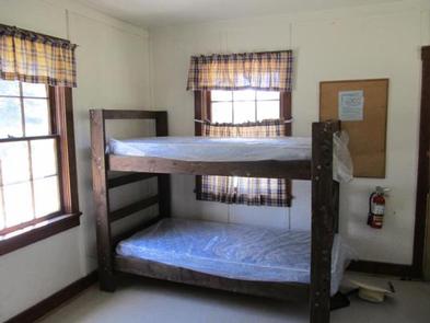
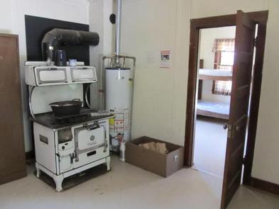
This rustic two-room cabin sleeps four people on two bunkbeds with mattresses. The kitchen is equipped with a propane stove, refrigerator that is shut off when not in use, propane lights and a small wood stove for heat. A picnic table and campfire ring are located outside the cabin.
Water is not available at this time. Guests should bring water for drinking and cooking. Outside vault toilet avalible year round with seasonal water faucet located outside. Some dishes, pots, pans and utensils are provided, however the presence of these items is not guaranteed.
No linens or bedding are provided. Recommended items to bring include food, bedding, dish soap, dish rags, toilet paper, garbage bags and a flashlight. If firewood is on site, this is a courtesy but is not guarenteed. If wood is available, please only use what you need. Always be prepared to collect locally or bring to site from local resources.
Natural Features
The cabin is perched on a grassy space surrounded by a stand of mixed conifers at 8,200 feet in elevation. Kelley Creek flows beside the guard station, offering a serene soundtrack of flowing water.
Moose, elk, eagles and sandhill cranes are among the wildlife likely to be seen. An abundance of wildflowers color the landscape in summer.
The Bridger-Teton National Forest offers more than 3.4 million acres of public land for outdoor recreation. With its pristine watersheds, abundant wildlife and immense wildlands, the forest comprises a large part of the Greater Yellowstone Ecosystem, the largest intact ecosystem in the lower 48 states.