BAY VIEW, MI Campground Reservation, Info, Images, Map, Directions

BAY VIEW, Michigan Campground Images, Info & Reservations

Directions

19456 W Lakeshore Drive, Brimley MI 49715

From Brimley, Michigan, travel west on County Road 42/Whitefish Bay Scenic Byway for approximately 8 miles. Bay View is on the north side of the road.

Phone

906-203-9872

Activities

HISTORIC & CULTURAL SITE, CAMPING, HIKING, SWIMMING SITE

Keywords

BYVW,Superior Lake Campground,Lake Superior Campground,Bay Campground,Byway Campground,HIAWATHA NF – FS

Related Link(s)

Rec Area Info & Images

Michigan State Tourism

Michigan State Road Conditions

Overview

Located just off the Whitefish Bay Scenic Byway in Michigan’s Upper Peninsula, Bay View Campground provides a rustic opportunity to camp along the shores of Lake Superior. The campground is a perfect stop amidst many recreational opportunities available in the Sault Ste. Marie area. Visitors also enjoy exploring the Whitefish Bay National Scenic Byway all the way to the beautiful Tahquamenon Falls.

Recreation

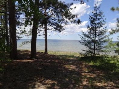
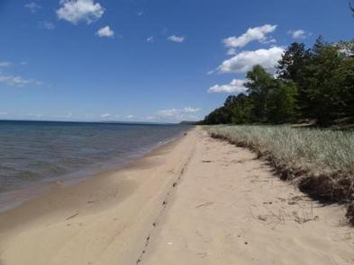
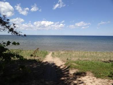
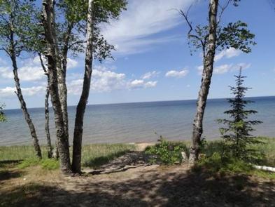
Miles of sandy beaches and beautiful sunsets stretch across Lake Superior, the greatest single body of fresh water in the world. Birding and sightseeing are popular pastimes, and visitors enjoy long walks along Superior’s beaches.

Facilities

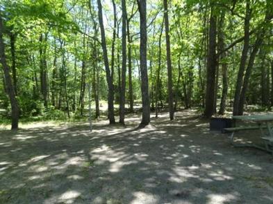
The rustic campground offers multiple single-family campsites for tent and RV camping. Each site is equipped with a picnic table and campfire rings with grills.

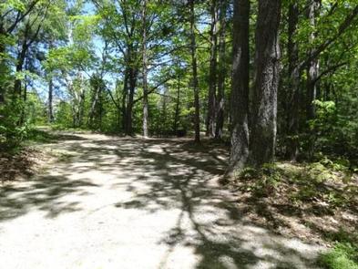
Vault toilets and hand-pumped drinking water are available at several locations within the campground. Most of the sites are heavily shaded. A campground host lives at the campground and can be available to answer any questions.

Natural Features

The campground is located in Lake Superior’s famous Whitefish Bay, the site of numerous historically preserved shipwrecks and lighthouse stations. The area is also a natural corridor for migratory birds.

Nearby Attractions

Tahquamenon Falls, a series of beautifully brown-colored waterfalls on the Tahquamenon River, are located just 30 miles away. The Great Lakes Shipwreck Museum and Whitefish Point Lighthouse are 39 miles to the north and west while the Point Iroquois Lighthouse lies about 8 miles east.

Charges & Cancellations

Please cancel 7 days in advance if you need to cancel your reservation. Reserve sites cannot be transferred to walk up sites.

Reservation

More from CampingHiking.net:

GRAHAM CORRAL HORSE CAMPGROUND, Oregon Campground Images, Info & Reservations

Directions From Sisters, OR: Travel 4.2 miles west on Highway 242 (McKenzie Pass Highway), then 2.0 miles north on Forest Road 1012, and then 0.8 miles northwest on Forest Road 1012 300. Phone 541-323-1746 Activities CAMPING, HORSEBACK RIDING, HORSE CAMPING Keywords Related Link(s) Rec Area Info & Images Oregon State

OSAGE BLUFF, Missouri Campground Images, Info & Reservations

Directions From Highway 83, travel about a mile on Osage Bluff Road. Follow signs into park. Phone 660-438-3873 Activities BOATING, CAMPING, FISHING, FISH HATCHERY Keywords UBAG,TRUMAN LAKE,HARRY S TRUMAN Related Link(s) Rec Area Info & Images Missouri State Road Conditions Missouri State Tourism Overview Osage Bluff Park sits on the

OHANAPECOSH GROUP CAMPGROUND, Washington Campground Images, Info & Reservations

Directions Located on State Route 123, four miles north of State Route 12. Phone 360-569-2211 x6627 Activities CAMPING, HIKING, PICNICKING, DAY USE AREA Keywords CG81,Ohana,Mount Rainier National Park Related Link(s) Rec Area Info & Images Washington State Road Conditions Washington State Tourism Overview This facility is the group site at

CULTUS LAKE CAMPGROUND, Oregon Campground Images, Info & Reservations

Directions From Bend, OR: Travel 46 miles southwest on Cascade Lakes Hwy (46), then west on Forest Road 4635 for 2 miles. Phone 541-323-1746 Activities BIKING, BOATING, CAMPING, FISHING, HIKING, MOTOR BOAT, MOUNTAIN BIKING, JET SKIING, AMPHITHEATER Keywords Related Link(s) Rec Area Info & Images Oregon State Road Conditions Oregon

LAKE FORK CAMPGROUND, Colorado Campground Images, Info & Reservations

Directions Lake Fork campground is located off of Hwy 50 between Gunnison and Montrose, along Blue Mesa reservoir. Phone 970-641-2337 Activities BIKING, BOATING, CAMPING, FISHING, HIKING, HUNTING, WATER SPORTS, WILDLIFE VIEWING, SWIMMING SITE Keywords LAFO,CURECANTI NATIONAL RECREATION,CURECANTI Related Link(s) Rec Area Info & Images Colorado State Road Conditions Colorado State